Yopal elevation
Yopal (Casanare), Colombia elevation is 338 meters and Yopal elevation in feet is 1109 ft above sea level [src 1]. Yopal is a seat of a first-order administrative division (feature code) with elevation that is 811 meters (2661 ft) smaller than average city elevation in Colombia.
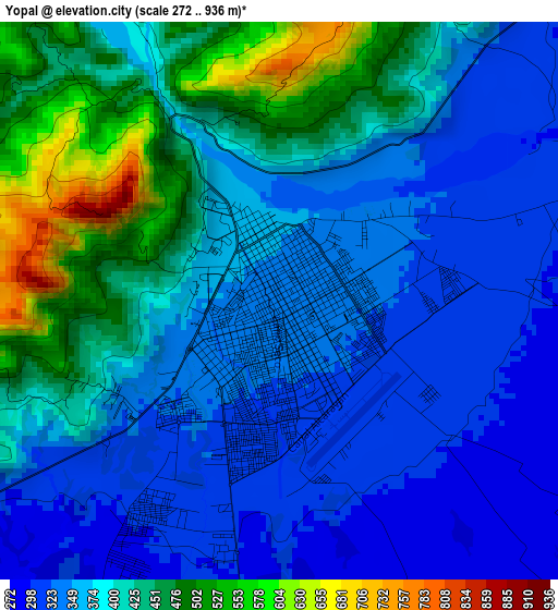
Below is the Elevation map of Yopal, which displays elevation range with different colors. Scale of the first map is from 272 to 936 m (892 to 3071 ft) with average elevation of 389 meters (=1276 ft) [note 1]
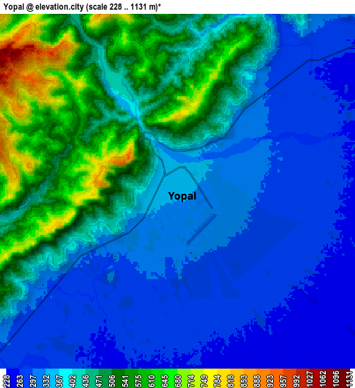
These maps also provides idea of topography and contour of this city, they are displayed at different zoom levels. More info about maps, scale and edge coordinates you can find below images.
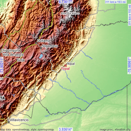
| \ | Map #1 | Map #2 | Topo.Map |
| Scale [m] | 272..936 m | 228..1131 m | × |
| Scale [ft] | 892..3071 ft | 748..3711 ft | × |
| Average | 389 m = 1276 ft | 401.4 m = 1317 ft | × |
| Width | 9.73 km = 6 mi | 19.46 km = 12.1 mi | 311.3 km = 193.4 mi |
| Height | 9.73 km = 6 mi | 19.46 km = 12.1 mi | 311.4 km = 193.5 mi |
| ↑Max Latitude | 5.381503° | 5.425253° | 6.73617° |
| Latitude at center | 5.33775° | 5.33775° | 5.33775° |
| ↓Min Latitude | 5.293994° | 5.250234° | 3.93614° |
| ← Min Longitude | -72.439805° | -72.483751° | -73.80211° |
| Longitude center | -72.39586° | -72.39586° | -72.39586° |
| →Max Longitude | -72.351915° | -72.307969° | -70.98961° |
Nearby cities:
Cities around Yopal sort by population:
• Villanueva elevation 185 m
47.9 km,  97°
97°
• Aguazul 276 m
24.8 km,  222°
222°
• Maní 164 m
59.4 km,  167°
167°
• Aquitania 3104 m
57.6 km,  290°
290°
• Tauramena 427 m
52.7 km,  227°
227°
• Nunchía 396 m
39.9 km,  33°
33°
• Pajarito 793 m
34.3 km,  261°
261°
• Chámeza 1126 m
54.2 km, 255°
• Labranzagrande 1128 m
31.9 km,  321°
321°
• Paya 984 m
32.1 km,  354°
354°
• Pisba 1461 m
44.1 km, 346°
• Recetor 972 m
42.2 km,  253°
253°
Multilingual:
 En español:
Yopal elevación 338 m.
 En France:
Yopal élévation 338 m.


Sources and notes:
- [note 1] Map square and city borders are not equal. Map elevation data is calculated only from area inside that square.
- [src 1] Elevation data from geonames database provided with same terms of usage.
- [src 2] The elevation map of Yopal is generated using elevation data from NASA's 3 arcsec (90m) resolution SRTM data.
- [src 3] Base (background) map © OpenStreetMap contributors tiles are generated by Geofabrik and OpenTopoMap.
Copyright & License:
This Yopal Elevation Map is licensed under CC BY-SA. You may reuse any part from this page, if you give a proper credit by linking to this URL:
 More info on terms of use page.