Bamenda elevation
Bamenda (North-West), Cameroon elevation is 1258 meters and Bamenda elevation in feet is 4127 ft above sea level [src 1]. Bamenda is a seat of a first-order administrative division (feature code) with elevation that is 583 meters (1913 ft) bigger than average city elevation in Cameroon.
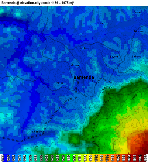
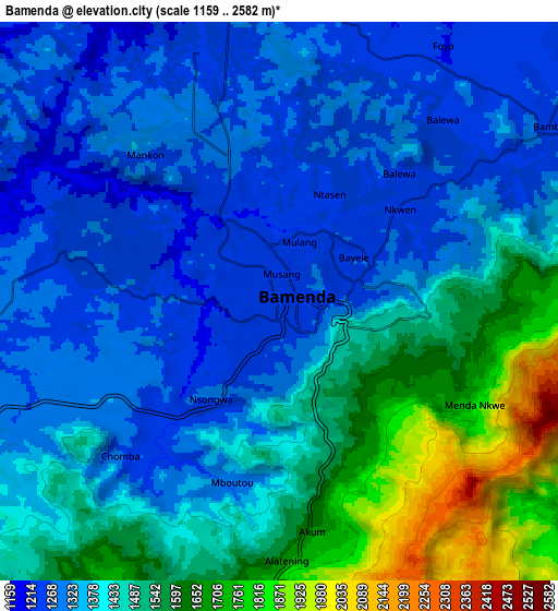
Below is the Elevation map of Bamenda, which displays elevation range with different colors. Scale of the first map is from 1186 to 1975 m (3891 to 6480 ft) with average elevation of 1309.8 meters (=4297 ft) [note 1]
These maps also provides idea of topography and contour of this city, they are displayed at different zoom levels. More info about maps, scale and edge coordinates you can find below images.
| \ | Map #1 | Map #2 | Topo.Map |
| Scale [m] | 1186..1975 m | 1159..2582 m | × |
| Scale [ft] | 3891..6480 ft | 3802..8471 ft | × |
| Average | 1309.8 m = 4297 ft | 1421.8 m = 4665 ft | × |
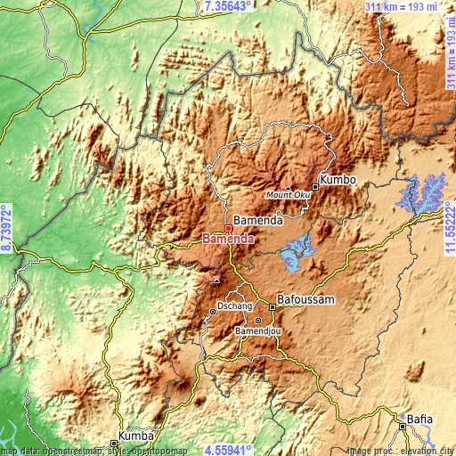
| Width | 9.72 km = 6 mi | 19.44 km = 12.1 mi | 311 km = 193.2 mi |
| Height | 9.72 km = 6 mi | 19.44 km = 12.1 mi | 311 km = 193.2 mi |
| ↑Max Latitude | 6.003406° | 6.047109° | 7.35643° |
| Latitude at center | 5.9597° | 5.9597° | 5.9597° |
| ↓Min Latitude | 5.91599° | 5.872277° | 4.55941° |
| ← Min Longitude | 10.102025° | 10.058079° | 8.73972° |
| Longitude center | 10.14597° | 10.14597° | 10.14597° |
| →Max Longitude | 10.189915° | 10.233861° | 11.55222° |
Nearby cities:
Cities around Bamenda sort by population:
• Mbouda elevation 1416 m
39 km,  162°
162°
• Dschang 1345 m
58.3 km,  190°
190°
• Bali 1355 m
16.9 km,  241°
241°
• Wum 1055 m
47.9 km,  349°
349°
• Fundong 1610 m
34.9 km,  22°
22°
• Babanki 1156 m
20.9 km,  33°
33°
• Mbengwi 1222 m
17.3 km,  291°
291°
• Batibo 1090 m
35 km,  246°
246°
• Belo 1138 m
22.5 km, 30°
• Njinikom 1315 m
34 km, 26°
• Mme-Bafumen 1403 m
42.7 km,  13°
13°
• Jakiri 1609 m
57.9 km,  74°
74°
Multilingual:
 En español:
Bamenda elevación 1258 m.
 En France:
Bamenda élévation 1258 m.
 Auf Deutsch:
Bamenda höhe über dem Meeresspiegel ist 1258 m.

Sources and notes:
- [note 1] Map square and city borders are not equal. Map elevation data is calculated only from area inside that square.
- [src 1] Elevation data from geonames database provided with same terms of usage.
- [src 2] The elevation map of Bamenda is generated using elevation data from NASA's 3 arcsec (90m) resolution SRTM data.
- [src 3] Base (background) map © OpenStreetMap contributors tiles are generated by Geofabrik and OpenTopoMap.
Copyright & License:
This Bamenda Elevation Map is licensed under CC BY-SA. You may reuse any part from this page, if you give a proper credit by linking to this URL:
 More info on terms of use page.