Ngambé elevation
Ngambé (Littoral, Département de la Sanaga-Maritime), Cameroon elevation is 575 meters and Ngambé elevation in feet is 1886 ft above sea level [src 1]. Ngambé is a populated place (feature code) with elevation that is 100 meters (328 ft) smaller than average city elevation in Cameroon.
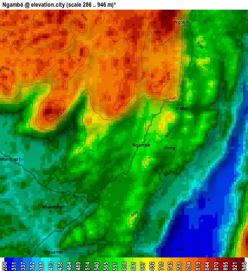
Below is the Elevation map of Ngambé, which displays elevation range with different colors. Scale of the first map is from 286 to 946 m (938 to 3104 ft) with average elevation of 582.3 meters (=1910 ft) [note 1]
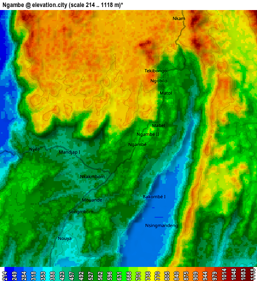
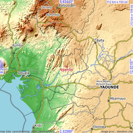
These maps also provides idea of topography and contour of this city, they are displayed at different zoom levels. More info about maps, scale and edge coordinates you can find below images.
| \ | Map #1 | Map #2 | Topo.Map |
| Scale [m] | 286..946 m | 214..1118 m | × |
| Scale [ft] | 938..3104 ft | 702..3668 ft | × |
| Average | 582.3 m = 1910 ft | 615.1 m = 2018 ft | × |
| Width | 9.75 km = 6.1 mi | 19.49 km = 12.1 mi | 311.8 km = 193.7 mi |
| Height | 9.75 km = 6.1 mi | 19.49 km = 12.1 mi | 311.9 km = 193.8 mi |
| ↑Max Latitude | 4.277254° | 4.321076° | 5.63443° |
| Latitude at center | 4.23343° | 4.23343° | 4.23343° |
| ↓Min Latitude | 4.189603° | 4.145774° | 2.82989° |
| ← Min Longitude | 10.571375° | 10.527429° | 9.20907° |
| Longitude center | 10.61532° | 10.61532° | 10.61532° |
| →Max Longitude | 10.659265° | 10.703211° | 12.02157° |
Nearby cities:
Cities around Ngambé sort by population:
• Edéa elevation 27 m
72 km,  227°
227°
• Bafia 480 m
89.4 km,  50°
50°
• Eséka 247 m
67 km,  165°
165°
• Dizangué 61 m
87.2 km, 233°
• Tonga 809 m
82.1 km,  6°
6°
• Bazou 1206 m
93.4 km,  349°
349°
• Ndikiniméki 803 m
64 km,  22°
22°
• Yabassi 49 m
75.9 km,  289°
289°
• Okola 652 m
88.5 km,  105°
105°
• Diang 56 m
66.4 km,  271°
271°
• Ombésa 459 m
81.3 km,  59°
59°
• Évodoula 562 m
67 km,  104°
104°
Multilingual:
 En español:
Ngambé elevación 575 m.
 En France:
Ngambé élévation 575 m.


Sources and notes:
- [note 1] Map square and city borders are not equal. Map elevation data is calculated only from area inside that square.
- [src 1] Elevation data from geonames database provided with same terms of usage.
- [src 2] The elevation map of Ngambé is generated using elevation data from NASA's 3 arcsec (90m) resolution SRTM data.
- [src 3] Base (background) map © OpenStreetMap contributors tiles are generated by Geofabrik and OpenTopoMap.
Copyright & License:
This Ngambé Elevation Map is licensed under CC BY-SA. You may reuse any part from this page, if you give a proper credit by linking to this URL:
 More info on terms of use page.