Ntui elevation
Ntui (Centre), Cameroon elevation is 526 meters and Ntui elevation in feet is 1726 ft above sea level [src 1]. Ntui is a populated place (feature code) with elevation that is 149 meters (489 ft) smaller than average city elevation in Cameroon.
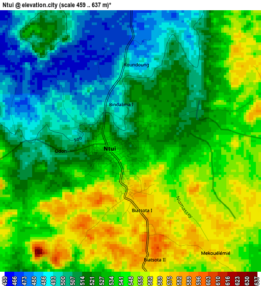
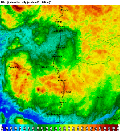
Below is the Elevation map of Ntui, which displays elevation range with different colors. Scale of the first map is from 459 to 637 m (1506 to 2090 ft) with average elevation of 528.4 meters (=1734 ft) [note 1]
These maps also provides idea of topography and contour of this city, they are displayed at different zoom levels. More info about maps, scale and edge coordinates you can find below images.
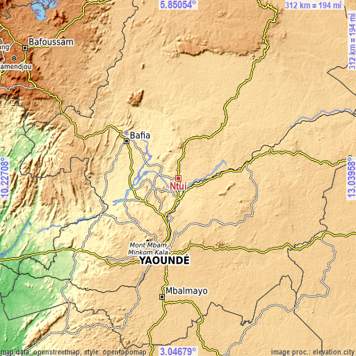
| \ | Map #1 | Map #2 | Topo.Map |
| Scale [m] | 459..637 m | 419..644 m | × |
| Scale [ft] | 1506..2090 ft | 1375..2113 ft | × |
| Average | 528.4 m = 1734 ft | 524.6 m = 1721 ft | × |
| Width | 9.74 km = 6.1 mi | 19.49 km = 12.1 mi | 311.7 km = 193.7 mi |
| Height | 9.74 km = 6.1 mi | 19.49 km = 12.1 mi | 311.8 km = 193.7 mi |
| ↑Max Latitude | 4.493812° | 4.53762° | 5.85054° |
| Latitude at center | 4.45° | 4.45° | 4.45° |
| ↓Min Latitude | 4.406186° | 4.362369° | 3.04679° |
| ← Min Longitude | 11.589385° | 11.545439° | 10.22708° |
| Longitude center | 11.63333° | 11.63333° | 11.63333° |
| →Max Longitude | 11.677275° | 11.721221° | 13.03958° |
Nearby cities:
Cities around Ntui sort by population:
• Yaoundé elevation 726 m
66.1 km,  191°
191°
• Bafia 480 m
55.5 km,  306°
306°
• Nkoteng 583 m
45 km,  80°
80°
• Obala 542 m
33.4 km,  199°
199°
• Mbandjok 548 m
29.6 km,  90°
90°
• Saa 512 m
22.3 km,  245°
245°
• Okola 652 m
55.6 km,  209°
209°
• Essé 640 m
48.9 km,  142°
142°
• Okoa 656 m
52 km,  184°
184°
• Ngoro 501 m
62.1 km,  333°
333°
• Ombésa 459 m
45.6 km,  291°
291°
• Évodoula 562 m
63 km,  229°
229°
Multilingual:
 En español:
Ntui elevación 526 m.
 En France:
Ntui élévation 526 m.


Sources and notes:
- [note 1] Map square and city borders are not equal. Map elevation data is calculated only from area inside that square.
- [src 1] Elevation data from geonames database provided with same terms of usage.
- [src 2] The elevation map of Ntui is generated using elevation data from NASA's 3 arcsec (90m) resolution SRTM data.
- [src 3] Base (background) map © OpenStreetMap contributors tiles are generated by Geofabrik and OpenTopoMap.
Copyright & License:
This Ntui Elevation Map is licensed under CC BY-SA. You may reuse any part from this page, if you give a proper credit by linking to this URL:
 More info on terms of use page.