Sangmélima elevation
Sangmélima (South), Cameroon elevation is 675 meters and Sangmélima elevation in feet is 2215 ft above sea level [src 1]. Sangmélima is a populated place (feature code) with elevation that is 0 meters (0 ft) bigger than average city elevation in Cameroon.
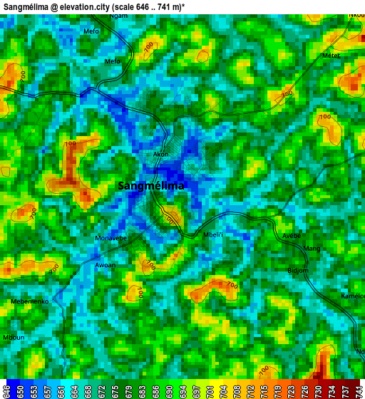
Below is the Elevation map of Sangmélima, which displays elevation range with different colors. Scale of the first map is from 646 to 741 m (2119 to 2431 ft) with average elevation of 678.4 meters (=2226 ft) [note 1]
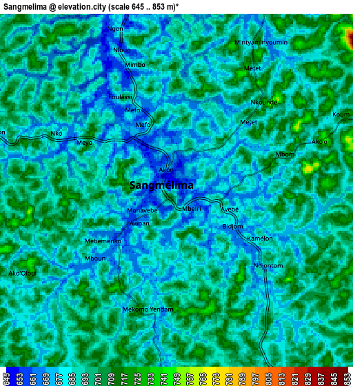
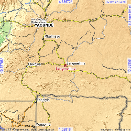
These maps also provides idea of topography and contour of this city, they are displayed at different zoom levels. More info about maps, scale and edge coordinates you can find below images.
| \ | Map #1 | Map #2 | Topo.Map |
| Scale [m] | 646..741 m | 645..853 m | × |
| Scale [ft] | 2119..2431 ft | 2116..2799 ft | × |
| Average | 678.4 m = 2226 ft | 689 m = 2260 ft | × |
| Width | 9.76 km = 6.1 mi | 19.52 km = 12.1 mi | 312.3 km = 194.1 mi |
| Height | 9.76 km = 6.1 mi | 19.52 km = 12.1 mi | 312.3 km = 194.1 mi |
| ↑Max Latitude | 2.977217° | 3.021102° | 4.33672° |
| Latitude at center | 2.93333° | 2.93333° | 2.93333° |
| ↓Min Latitude | 2.889441° | 2.845551° | 1.52818° |
| ← Min Longitude | 11.939385° | 11.895439° | 10.57708° |
| Longitude center | 11.98333° | 11.98333° | 11.98333° |
| →Max Longitude | 12.027275° | 12.071221° | 13.38958° |
Nearby cities:
Cities around Sangmélima sort by population:
• Yaoundé elevation 726 m
116 km,  333°
333°
• Ébolowa 583 m
92.6 km,  267°
267°
• Mbalmayo 663 m
84.2 km,  320°
320°
• Akonolinga 643 m
97.3 km,  17°
17°
• Ambam 570 m
98.9 km,  231°
231°
• Okola 652 m
137.6 km, 331°
• Ngomedzap 701 m
93.8 km,  292°
292°
• Akono 678 m
95.8 km,  311°
311°
• Essé 640 m
130.1 km,  355°
355°
• Okoa 656 m
124.3 km,  339°
339°
• Mbankomo 732 m
115.6 km, 324°
• Mvangué 697 m
52 km, 274°
Multilingual:
 En español:
Sangmélima elevación 675 m.
 En France:
Sangmélima élévation 675 m.
 Auf Deutsch:
Sangmélima höhe über dem Meeresspiegel ist 675 m.

Sources and notes:
- [note 1] Map square and city borders are not equal. Map elevation data is calculated only from area inside that square.
- [src 1] Elevation data from geonames database provided with same terms of usage.
- [src 2] The elevation map of Sangmélima is generated using elevation data from NASA's 3 arcsec (90m) resolution SRTM data.
- [src 3] Base (background) map © OpenStreetMap contributors tiles are generated by Geofabrik and OpenTopoMap.
Copyright & License:
This Sangmélima Elevation Map is licensed under CC BY-SA. You may reuse any part from this page, if you give a proper credit by linking to this URL:
 More info on terms of use page.