Angol elevation
Angol (Araucanía, Provincia de Malleco), Chile elevation is 101 meters and Angol elevation in feet is 331 ft above sea level [src 1]. Angol is a seat of a second-order administrative division (feature code) with elevation that is 174 meters (571 ft) smaller than average city elevation in Chile.
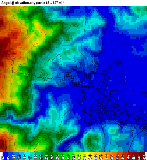
Below is the Elevation map of Angol, which displays elevation range with different colors. Scale of the first map is from 63 to 627 m (207 to 2057 ft) with average elevation of 185 meters (=607 ft) [note 1]
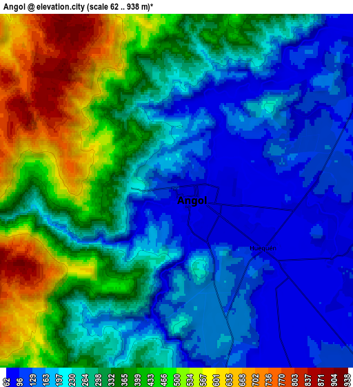
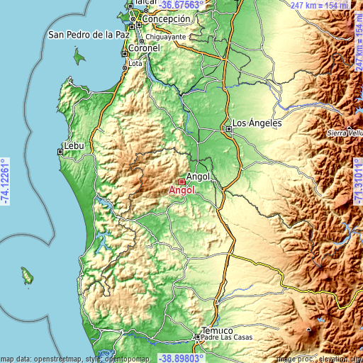
These maps also provides idea of topography and contour of this city, they are displayed at different zoom levels. More info about maps, scale and edge coordinates you can find below images.
| \ | Map #1 | Map #2 | Topo.Map |
| Scale [m] | 63..627 m | 62..938 m | × |
| Scale [ft] | 207..2057 ft | 203..3077 ft | × |
| Average | 185 m = 607 ft | 294.2 m = 965 ft | × |
| Width | 7.72 km = 4.8 mi | 15.44 km = 9.6 mi | 247.1 km = 153.5 mi |
| Height | 7.72 km = 4.8 mi | 15.44 km = 9.6 mi | 247.1 km = 153.5 mi |
| ↑Max Latitude | -37.760456° | -37.725706° | -36.67563° |
| Latitude at center | -37.79519° | -37.79519° | -37.79519° |
| ↓Min Latitude | -37.829908° | -37.864609° | -38.89803° |
| ← Min Longitude | -72.760305° | -72.804251° | -74.12261° |
| Longitude center | -72.71636° | -72.71636° | -72.71636° |
| →Max Longitude | -72.672415° | -72.628469° | -71.31011° |
Nearby cities:
Cities around Angol sort by population:
• Los Ángeles elevation 141 m
48.3 km,  41°
41°
• Curanilahue 141 m
65.6 km,  302°
302°
• Arauco 13 m
80.8 km,  319°
319°
• Victoria 355 m
59.1 km,  145°
145°
• Lebu 12 m
85 km,  284°
284°
• Mulchén 139 m
42.6 km,  78°
78°
• Nacimiento 95 m
32.8 km,  6°
6°
• Cañete 69 m
59.7 km,  269°
269°
• Laja 60 m
56.8 km,  0°
0°
• Collipulli 257 m
30.4 km,  125°
125°
• Traiguén 180 m
50.7 km,  175°
175°
• Yumbel 105 m
78.7 km, 10°
Multilingual:
 En español:
Angol elevación 101 m.
 En France:
Angol élévation 101 m.


Sources and notes:
- [note 1] Map square and city borders are not equal. Map elevation data is calculated only from area inside that square.
- [src 1] Elevation data from geonames database provided with same terms of usage.
- [src 2] The elevation map of Angol is generated using elevation data from NASA's 3 arcsec (90m) resolution SRTM data.
- [src 3] Base (background) map © OpenStreetMap contributors tiles are generated by Geofabrik and OpenTopoMap.
Copyright & License:
This Angol Elevation Map is licensed under CC BY-SA. You may reuse any part from this page, if you give a proper credit by linking to this URL:
 More info on terms of use page.