Coihueco elevation
Coihueco (Ñuble, Provincia de Punilla), Chile elevation is 257 meters and Coihueco elevation in feet is 843 ft above sea level [src 1]. Coihueco is a populated place (feature code) with elevation that is 18 meters (59 ft) smaller than average city elevation in Chile.
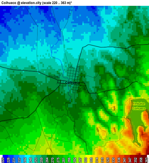
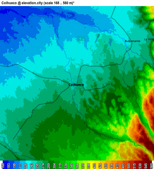
Below is the Elevation map of Coihueco, which displays elevation range with different colors. Scale of the first map is from 220 to 363 m (722 to 1191 ft) with average elevation of 265.9 meters (=872 ft) [note 1]
These maps also provides idea of topography and contour of this city, they are displayed at different zoom levels. More info about maps, scale and edge coordinates you can find below images.
| \ | Map #1 | Map #2 | Topo.Map |
| Scale [m] | 220..363 m | 168..560 m | × |
| Scale [ft] | 722..1191 ft | 551..1837 ft | × |
| Average | 265.9 m = 872 ft | 277.5 m = 910 ft | × |
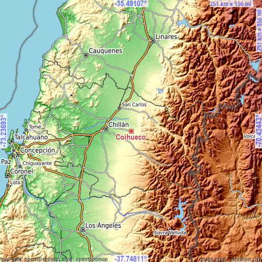
| Width | 7.84 km = 4.9 mi | 15.69 km = 9.7 mi | 251 km = 156 mi |
| Height | 7.84 km = 4.9 mi | 15.69 km = 9.7 mi | 251 km = 156 mi |
| ↑Max Latitude | -36.592575° | -36.557283° | -35.49107° |
| Latitude at center | -36.62785° | -36.62785° | -36.62785° |
| ↓Min Latitude | -36.663109° | -36.698352° | -37.74811° |
| ← Min Longitude | -71.874625° | -71.918571° | -73.23693° |
| Longitude center | -71.83068° | -71.83068° | -71.83068° |
| →Max Longitude | -71.786735° | -71.742789° | -70.42443° |
Nearby cities:
Cities around Coihueco sort by population:
• Chillán elevation 132 m
24.5 km,  275°
275°
• Los Ángeles 141 m
104.5 km,  206°
206°
• Linares 165 m
89.4 km,  13°
13°
• Tomé 16 m
100.4 km,  270°
270°
• San Carlos 186 m
25.3 km,  333°
333°
• Cauquenes 172 m
85.7 km, 329°
• Parral 178 m
53.9 km,  0°
0°
• Cabrero 129 m
68.2 km,  228°
228°
• Bulnes 96 m
43.6 km,  253°
253°
• Yumbel 105 m
83.4 km, 231°
• Quirihue 262 m
74.4 km,  301°
301°
• Longaví 153 m
74.9 km, 10°
Multilingual:
 En español:
Coihueco elevación 257 m.
 En France:
Coihueco élévation 257 m.
 Auf Deutsch:
Coihueco höhe über dem Meeresspiegel ist 257 m.

Sources and notes:
- [note 1] Map square and city borders are not equal. Map elevation data is calculated only from area inside that square.
- [src 1] Elevation data from geonames database provided with same terms of usage.
- [src 2] The elevation map of Coihueco is generated using elevation data from NASA's 3 arcsec (90m) resolution SRTM data.
- [src 3] Base (background) map © OpenStreetMap contributors tiles are generated by Geofabrik and OpenTopoMap.
Copyright & License:
This Coihueco Elevation Map is licensed under CC BY-SA. You may reuse any part from this page, if you give a proper credit by linking to this URL:
 More info on terms of use page.