Los Andes elevation
Los Andes (Valparaíso, Provincia de Los Andes), Chile elevation is 833 meters and Los Andes elevation in feet is 2733 ft above sea level [src 1]. Los Andes is a populated place (feature code) with elevation that is 558 meters (1831 ft) bigger than average city elevation in Chile.
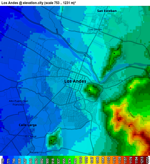
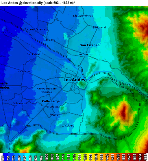
Below is the Elevation map of Los Andes, which displays elevation range with different colors. Scale of the first map is from 753 to 1231 m (2470 to 4039 ft) with average elevation of 844.3 meters (=2770 ft) [note 1]
These maps also provides idea of topography and contour of this city, they are displayed at different zoom levels. More info about maps, scale and edge coordinates you can find below images.
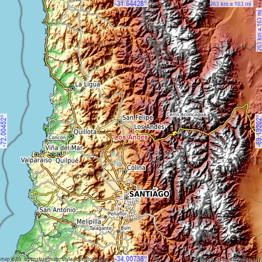
| \ | Map #1 | Map #2 | Topo.Map |
| Scale [m] | 753..1231 m | 693..1692 m | × |
| Scale [ft] | 2470..4039 ft | 2274..5551 ft | × |
| Average | 844.3 m = 2770 ft | 900.5 m = 2954 ft | × |
| Width | 8.21 km = 5.1 mi | 16.42 km = 10.2 mi | 262.8 km = 163.3 mi |
| Height | 8.21 km = 5.1 mi | 16.42 km = 10.2 mi | 262.8 km = 163.3 mi |
| ↑Max Latitude | -32.796757° | -32.759809° | -31.64428° |
| Latitude at center | -32.83369° | -32.83369° | -32.83369° |
| ↓Min Latitude | -32.870607° | -32.907509° | -34.00738° |
| ← Min Longitude | -70.642215° | -70.686161° | -72.00452° |
| Longitude center | -70.59827° | -70.59827° | -70.59827° |
| →Max Longitude | -70.554325° | -70.510379° | -69.19202° |
Nearby cities:
Cities around Los Andes sort by population:
• Santiago elevation 556 m
69.5 km,  183°
183°
• Lo Prado 509 m
68.9 km,  189°
189°
• Quillota 128 m
61 km,  264°
264°
• San Felipe 654 m
15.1 km,  308°
308°
• Hacienda La Calera 203 m
58.1 km,  275°
275°
• Limache 107 m
65.6 km,  251°
251°
• Lampa 498 m
56.6 km,  207°
207°
• Chicureo Abajo 563 m
50.3 km, 185°
• Llaillay 395 m
33.5 km,  268°
268°
• Villa Presidente Frei, Ñuñoa, Santiago, Chile 606 m
69.7 km, 178°
• Providencia 615 m
66.4 km, 180°
• Colina 599 m
41.8 km, 189°
Multilingual:
 En español:
Los Andes elevación 833 m.
 En France:
Los Andes élévation 833 m.
 Auf Deutsch:
Los Andes höhe über dem Meeresspiegel ist 833 m.
 На русском:
Лос-Анд, Лос-Андес высота над уровнем моря 833 м
Sources and notes:
- [note 1] Map square and city borders are not equal. Map elevation data is calculated only from area inside that square.
- [src 1] Elevation data from geonames database provided with same terms of usage.
- [src 2] The elevation map of Los Andes is generated using elevation data from NASA's 3 arcsec (90m) resolution SRTM data.
- [src 3] Base (background) map © OpenStreetMap contributors tiles are generated by Geofabrik and OpenTopoMap.
Copyright & License:
This Los Andes Elevation Map is licensed under CC BY-SA. You may reuse any part from this page, if you give a proper credit by linking to this URL:
 More info on terms of use page.