Talagante elevation
Talagante (Santiago Metropolitan, Provincia de Talagante), Chile elevation is 344 meters and Talagante elevation in feet is 1129 ft above sea level [src 1]. Talagante is a seat of a second-order administrative division (feature code) with elevation that is 69 meters (226 ft) bigger than average city elevation in Chile.
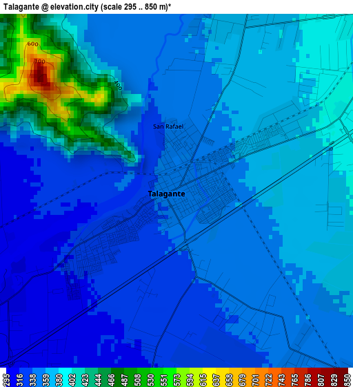
Below is the Elevation map of Talagante, which displays elevation range with different colors. Scale of the first map is from 295 to 850 m (968 to 2789 ft) with average elevation of 363.6 meters (=1193 ft) [note 1]
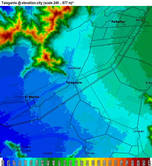
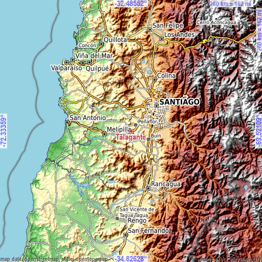
These maps also provides idea of topography and contour of this city, they are displayed at different zoom levels. More info about maps, scale and edge coordinates you can find below images.
| \ | Map #1 | Map #2 | Topo.Map |
| Scale [m] | 295..850 m | 249..877 m | × |
| Scale [ft] | 968..2789 ft | 817..2877 ft | × |
| Average | 363.6 m = 1193 ft | 373.1 m = 1224 ft | × |
| Width | 8.13 km = 5.1 mi | 16.27 km = 10.1 mi | 260.3 km = 161.7 mi |
| Height | 8.13 km = 5.1 mi | 16.27 km = 10.1 mi | 260.3 km = 161.7 mi |
| ↑Max Latitude | -33.627276° | -33.590677° | -32.48552° |
| Latitude at center | -33.66386° | -33.66386° | -33.66386° |
| ↓Min Latitude | -33.700428° | -33.736981° | -34.82628° |
| ← Min Longitude | -70.971285° | -71.015231° | -72.33359° |
| Longitude center | -70.92734° | -70.92734° | -70.92734° |
| →Max Longitude | -70.883395° | -70.839449° | -69.52109° |
Nearby cities:
Cities around Talagante sort by population:
• Santiago elevation 556 m
34.6 km,  48°
48°
• Puente Alto 700 m
33.1 km,  79°
79°
• San Bernardo 571 m
22.5 km,  69°
69°
• La Pintana 630 m
28.6 km, 71°
• Lo Prado 509 m
30.8 km,  37°
37°
• Peñaflor 395 m
7.9 km, 36°
• Melipilla 175 m
26.8 km,  263°
263°
• Buin 483 m
18.7 km,  114°
114°
• Paine 407 m
23.5 km,  132°
132°
• El Monte 300 m
5.6 km,  251°
251°
• Villa Presidente Frei, Ñuñoa, Santiago, Chile 606 m
39.3 km, 54°
• Providencia 615 m
39.6 km, 49°
Multilingual:
 En español:
Talagante elevación 344 m.
 En France:
Talagante élévation 344 m.
 Auf Deutsch:
Talagante höhe über dem Meeresspiegel ist 344 m.

Sources and notes:
- [note 1] Map square and city borders are not equal. Map elevation data is calculated only from area inside that square.
- [src 1] Elevation data from geonames database provided with same terms of usage.
- [src 2] The elevation map of Talagante is generated using elevation data from NASA's 3 arcsec (90m) resolution SRTM data.
- [src 3] Base (background) map © OpenStreetMap contributors tiles are generated by Geofabrik and OpenTopoMap.
Copyright & License:
This Talagante Elevation Map is licensed under CC BY-SA. You may reuse any part from this page, if you give a proper credit by linking to this URL:
 More info on terms of use page.