Orny elevation
Orny (Vaud, Morges District), Switzerland elevation is 466 meters and Orny elevation in feet is 1529 ft above sea level [src 1]. Orny is a seat of a third-order administrative division (feature code) with elevation that is 82 meters (269 ft) smaller than average city elevation in Switzerland.
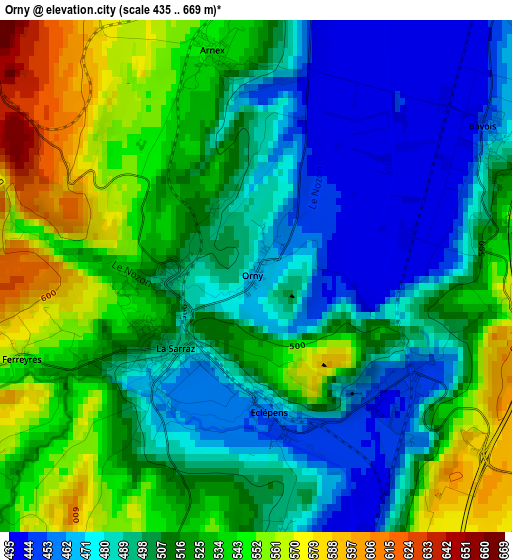
Below is the Elevation map of Orny, which displays elevation range with different colors. Scale of the first map is from 435 to 669 m (1427 to 2195 ft) with average elevation of 510.5 meters (=1675 ft) [note 1]
These maps also provides idea of topography and contour of this city, they are displayed at different zoom levels. More info about maps, scale and edge coordinates you can find below images.
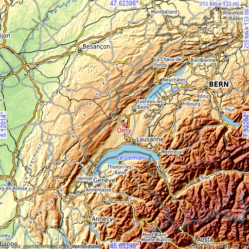
| \ | Map #1 | Topo.Map |
| Scale [m] | 435..669 m | × |
| Scale [ft] | 1427..2195 ft | × |
| Average | 510.5 m = 1675 ft | × |
| Width | 6.71 km = 4.2 mi | 214.6 km = 133.3 mi |
| Height | 6.71 km = 4.2 mi | 214.6 km = 133.3 mi |
| ↑Max Latitude | 46.697728° | 47.62398° |
| Latitude at center | 46.66758° | 46.66758° |
| ↓Min Latitude | 46.637415° | 45.69395° |
| ← Min Longitude | 6.482445° | 5.12014° |
| Longitude center | 6.52639° | 6.52639° |
| →Max Longitude | 6.570335° | 7.93264° |
Nearby cities:
Cities around Orny sort by population:
• Orbe elevation 477 m
6.4 km,  2°
2°
• Chavornay 455 m
5.1 km,  40°
40°
• Cossonay 565 m
6.1 km,  194°
194°
• Penthalaz 455 m
6.3 km,  180°
180°
• La Sarraz 490 m
1.6 km,  230°
230°
• Bavois 462 m
3.6 km,  59°
59°
• La Chaux 557 m
7 km,  216°
216°
• Penthéréaz 623 m
6.1 km,  75°
75°
• Moiry 625 m
5.9 km,  249°
249°
• Chevilly 578 m
4.7 km, 233°
• Ferreyres 562 m
3.3 km, 251°
• Pompaples 491 m
1.3 km,  267°
267°
Multilingual:
 En español:
Orny elevación 466 m.
 En France:
Orny élévation 466 m.


Sources and notes:
- [note 1] Map square and city borders are not equal. Map elevation data is calculated only from area inside that square.
- [src 1] Elevation data from geonames database provided with same terms of usage.
- [src 2] The elevation map of Orny is generated using elevation data from NASA's 3 arcsec (90m) resolution SRTM data.
- [src 3] Base (background) map © OpenStreetMap contributors tiles are generated by Geofabrik and OpenTopoMap.
Copyright & License:
This Orny Elevation Map is licensed under CC BY-SA. You may reuse any part from this page, if you give a proper credit by linking to this URL:
 More info on terms of use page.