Zürich (Kreis 3) elevation
Zürich (Kreis 3) (Zurich, Bezirk Zürich), Switzerland elevation is 507 meters and Zürich (Kreis 3) elevation in feet is 1663 ft above sea level [src 1]. Zürich (Kreis 3) is a section of populated place (feature code) with elevation that is 41 meters (135 ft) smaller than average city elevation in Switzerland.
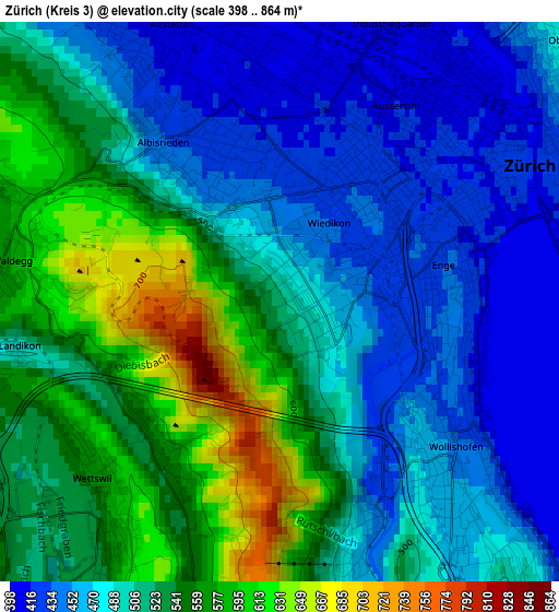
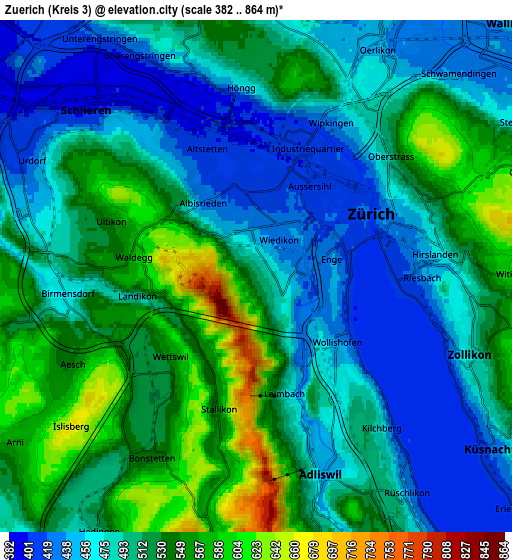
Below is the Elevation map of Zürich (Kreis 3), which displays elevation range with different colors. Scale of the first map is from 398 to 864 m (1306 to 2835 ft) with average elevation of 506.4 meters (=1661 ft) [note 1]
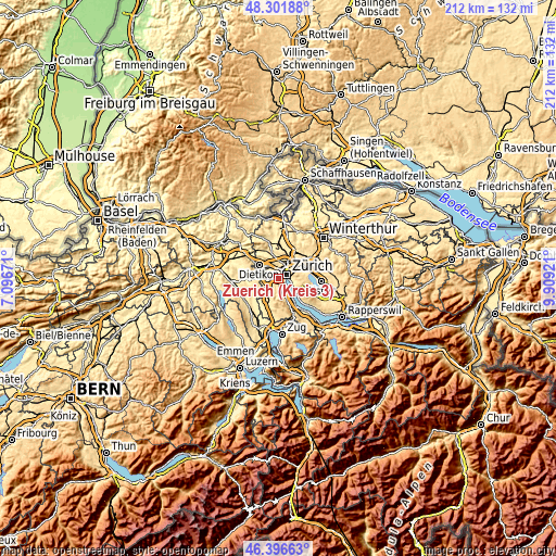
These maps also provides idea of topography and contour of this city, they are displayed at different zoom levels. More info about maps, scale and edge coordinates you can find below images.
| \ | Map #1 | Map #2 | Topo.Map |
| Scale [m] | 398..864 m | 382..864 m | × |
| Scale [ft] | 1306..2835 ft | 1253..2835 ft | × |
| Average | 506.4 m = 1661 ft | 503 m = 1650 ft | × |
| Width | 6.62 km = 4.1 mi | 13.24 km = 8.2 mi | 211.8 km = 131.6 mi |
| Height | 6.62 km = 4.1 mi | 13.24 km = 8.2 mi | 211.8 km = 131.6 mi |
| ↑Max Latitude | 47.387611° | 47.417355° | 48.30188° |
| Latitude at center | 47.35785° | 47.35785° | 47.35785° |
| ↓Min Latitude | 47.328072° | 47.298278° | 46.39663° |
| ← Min Longitude | 8.459015° | 8.415069° | 7.09671° |
| Longitude center | 8.50296° | 8.50296° | 8.50296° |
| →Max Longitude | 8.546905° | 8.590851° | 9.90921° |
Nearby cities:
Cities around Zürich (Kreis 3) sort by population:
• Zürich (Kreis 2) elevation 439 m
2.6 km,  148°
148°
• Zürich (Kreis 4) / Aussersihl 416 m
2.6 km,  32°
32°
• Zürich (Kreis 3) / Sihlfeld 416 m
1.9 km,  20°
20°
• Zürich (Kreis 9) / Albisrieden 428 m
2 km,  331°
331°
• Zürich (Kreis 3) / Alt-Wiedikon 431 m
1 km,  62°
62°
• Zürich (Kreis 4) / Hard 410 m
2.9 km,  9°
9°
• Zürich (Kreis 4) / Langstrasse 412 m
2.9 km,  41°
41°
• Zürich (Kreis 3) / Friesenberg 465 m
0.7 km, 7°
• Zürich (Kreis 2) / Enge 421 m
2.2 km,  82°
82°
• Zürich (Kreis 4) / Werd 418 m
2.3 km,  48°
48°
• Zürich (Kreis 2) / Unter-Leimbach 477 m
2.8 km,  162°
162°
• Sellenbüren 561 m
2.2 km,  223°
223°
Multilingual:
 En español:
Zürich (Kreis 3) elevación 507 m.
 En France:
Zürich (Kreis 3) élévation 507 m.
 Auf Deutsch:
Zürich (Kreis 3) höhe über dem Meeresspiegel ist 507 m.

Sources and notes:
- [note 1] Map square and city borders are not equal. Map elevation data is calculated only from area inside that square.
- [src 1] Elevation data from geonames database provided with same terms of usage.
- [src 2] The elevation map of Zürich (Kreis 3) is generated using elevation data from NASA's 3 arcsec (90m) resolution SRTM data.
- [src 3] Base (background) map © OpenStreetMap contributors tiles are generated by Geofabrik and OpenTopoMap.
Copyright & License:
This Zürich (Kreis 3) Elevation Map is licensed under CC BY-SA. You may reuse any part from this page, if you give a proper credit by linking to this URL:
 More info on terms of use page.