Mattenbach (Kreis 7) / Deutweg elevation
Mattenbach (Kreis 7) / Deutweg (Zurich, Bezirk Winterthur), Switzerland elevation is 447 meters and Mattenbach (Kreis 7) / Deutweg elevation in feet is 1467 ft above sea level [src 1]. Mattenbach (Kreis 7) / Deutweg is a section of populated place (feature code) with elevation that is 101 meters (331 ft) smaller than average city elevation in Switzerland.
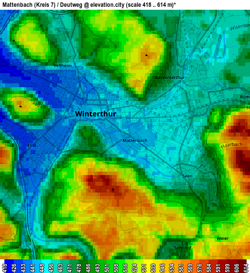
Below is the Elevation map of Mattenbach (Kreis 7) / Deutweg, which displays elevation range with different colors. Scale of the first map is from 418 to 614 m (1371 to 2014 ft) with average elevation of 488.3 meters (=1602 ft) [note 1]
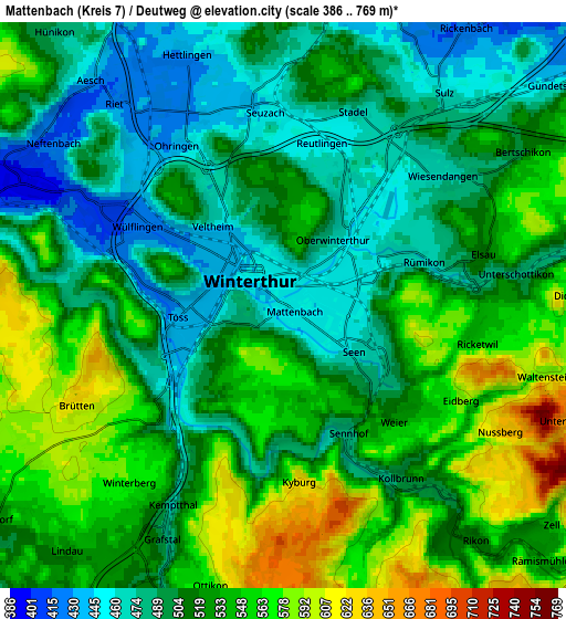
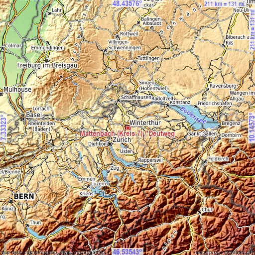
These maps also provides idea of topography and contour of this city, they are displayed at different zoom levels. More info about maps, scale and edge coordinates you can find below images.
| \ | Map #1 | Map #2 | Topo.Map |
| Scale [m] | 418..614 m | 386..769 m | × |
| Scale [ft] | 1371..2014 ft | 1266..2523 ft | × |
| Average | 488.3 m = 1602 ft | 518.7 m = 1702 ft | × |
| Width | 6.6 km = 4.1 mi | 13.21 km = 8.2 mi | 211.3 km = 131.3 mi |
| Height | 6.6 km = 4.1 mi | 13.21 km = 8.2 mi | 211.3 km = 131.3 mi |
| ↑Max Latitude | 47.523874° | 47.553541° | 48.43576° |
| Latitude at center | 47.49419° | 47.49419° | 47.49419° |
| ↓Min Latitude | 47.464489° | 47.434772° | 46.53543° |
| ← Min Longitude | 8.695535° | 8.651589° | 7.33323° |
| Longitude center | 8.73948° | 8.73948° | 8.73948° |
| →Max Longitude | 8.783425° | 8.827371° | 10.14573° |
Nearby cities:
Cities around Mattenbach (Kreis 7) / Deutweg sort by population:
• Winterthur elevation 441 m
1.7 km,  317°
317°
• Stadt Winterthur (Kreis 1) 439 m
1.5 km,  273°
273°
• Mattenbach (Kreis 7) 446 m
1 km,  145°
145°
• Oberwinterthur (Kreis 2) / Talacker 475 m
1.6 km,  34°
34°
• Stadt Winterthur (Kreis 1) / Lind 452 m
1.4 km,  341°
341°
• Seen (Kreis 3) / Waser 457 m
1.7 km,  109°
109°
• Stadt Winterthur (Kreis 1) / Heiligberg 474 m
1.2 km, 269°
• Mattenbach (Kreis 7) / Gutschick 453 m
1 km, 109°
• Stadt Winterthur (Kreis 1) / Tössfeld 438 m
1.8 km, 267°
• Mattenbach (Kreis 7) / Endliker 456 m
1 km,  131°
131°
• Stadt Winterthur (Kreis 1) / Altstadt 451 m
1 km,  306°
306°
• Seen (Kreis 3) / Waldegg 456 m
1.7 km, 132°
Multilingual:
 En español:
Mattenbach (Kreis 7) / Deutweg elevación 447 m.
 En France:
Mattenbach (Kreis 7) / Deutweg élévation 447 m.
 Auf Deutsch:
Mattenbach (Kreis 7) / Deutweg höhe über dem Meeresspiegel ist 447 m.
 На русском:
Mattenbach (Kreis 7) / Deutweg высота над уровнем моря 447 м
Sources and notes:
- [note 1] Map square and city borders are not equal. Map elevation data is calculated only from area inside that square.
- [src 1] Elevation data from geonames database provided with same terms of usage.
- [src 2] The elevation map of Mattenbach (Kreis 7) / Deutweg is generated using elevation data from NASA's 3 arcsec (90m) resolution SRTM data.
- [src 3] Base (background) map © OpenStreetMap contributors tiles are generated by Geofabrik and OpenTopoMap.
Copyright & License:
This Mattenbach (Kreis 7) / Deutweg Elevation Map is licensed under CC BY-SA. You may reuse any part from this page, if you give a proper credit by linking to this URL:
 More info on terms of use page.