Aesch elevation
Aesch (Zurich, Bezirk Uster), Switzerland elevation is 636 meters and Aesch elevation in feet is 2087 ft above sea level [src 1]. Aesch is a populated place (feature code) with elevation that is 88 meters (289 ft) bigger than average city elevation in Switzerland.
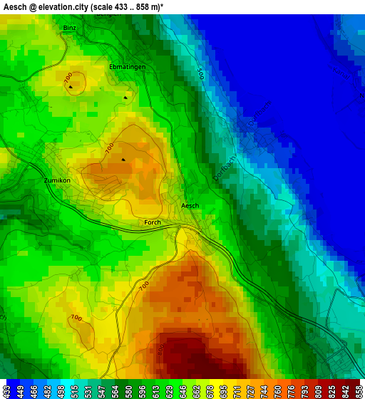
Below is the Elevation map of Aesch, which displays elevation range with different colors. Scale of the first map is from 433 to 858 m (1421 to 2815 ft) with average elevation of 598.5 meters (=1964 ft) [note 1]
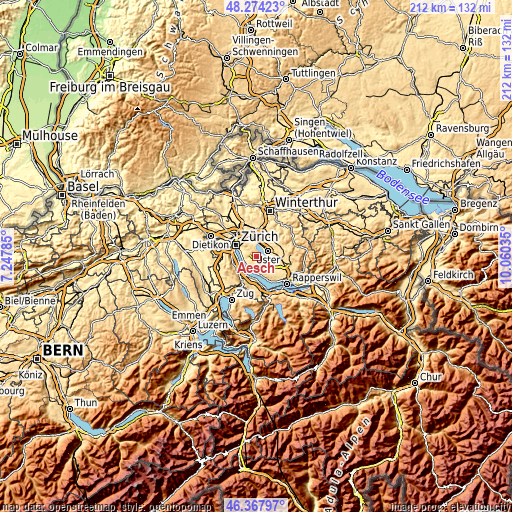
These maps also provides idea of topography and contour of this city, they are displayed at different zoom levels. More info about maps, scale and edge coordinates you can find below images.
| \ | Map #1 | Topo.Map |
| Scale [m] | 433..858 m | × |
| Scale [ft] | 1421..2815 ft | × |
| Average | 598.5 m = 1964 ft | × |
| Width | 6.62 km = 4.1 mi | 212 km = 131.7 mi |
| Height | 6.62 km = 4.1 mi | 211.9 km = 131.7 mi |
| ↑Max Latitude | 47.359477° | 48.27423° |
| Latitude at center | 47.3297° | 47.3297° |
| ↓Min Latitude | 47.299906° | 46.36797° |
| ← Min Longitude | 8.610155° | 7.24785° |
| Longitude center | 8.6541° | 8.6541° |
| →Max Longitude | 8.698045° | 10.06035° |
Nearby cities:
Cities around Aesch sort by population:
• Greifensee elevation 444 m
4.6 km,  26°
26°
• Zumikon 649 m
2.4 km,  275°
275°
• Zollikerberg 614 m
4.4 km,  293°
293°
• Uster / Nieder-Uster 459 m
4 km,  60°
60°
• Egg 548 m
4.3 km,  140°
140°
• Küsnacht / Itschnach 584 m
4 km,  265°
265°
• Ebmatingen 630 m
2.5 km,  334°
334°
• Benglen 572 m
3.7 km,  339°
339°
• Pfaffhausen 597 m
4.5 km, 329°
• Binz 633 m
3.6 km, 325°
• Erlenbach / rechts des Dorfbachs oberhalb Bahnlinie 533 m
4.6 km,  236°
236°
• Hinteregg 563 m
3.3 km, 138°
Multilingual:
 En español:
Aesch elevación 636 m.
 En France:
Aesch élévation 636 m.


Sources and notes:
- [note 1] Map square and city borders are not equal. Map elevation data is calculated only from area inside that square.
- [src 1] Elevation data from geonames database provided with same terms of usage.
- [src 2] The elevation map of Aesch is generated using elevation data from NASA's 3 arcsec (90m) resolution SRTM data.
- [src 3] Base (background) map © OpenStreetMap contributors tiles are generated by Geofabrik and OpenTopoMap.
Copyright & License:
This Aesch Elevation Map is licensed under CC BY-SA. You may reuse any part from this page, if you give a proper credit by linking to this URL:
 More info on terms of use page.