Büsserach elevation
Büsserach (Solothurn, Bezirk Thierstein), Switzerland elevation is 416 meters and Büsserach elevation in feet is 1365 ft above sea level [src 1]. Büsserach is a populated place (feature code) with elevation that is 132 meters (433 ft) smaller than average city elevation in Switzerland.
Below is the Elevation map of Büsserach, which displays elevation range with different colors. Scale of the first map is from 346 to 919 m (1135 to 3015 ft) with average elevation of 537.5 meters (=1763 ft) [note 1]
These maps also provides idea of topography and contour of this city, they are displayed at different zoom levels. More info about maps, scale and edge coordinates you can find below images.
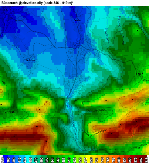
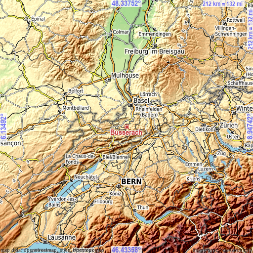
| \ | Map #1 | Topo.Map |
| Scale [m] | 346..919 m | × |
| Scale [ft] | 1135..3015 ft | × |
| Average | 537.5 m = 1763 ft | × |
| Width | 6.62 km = 4.1 mi | 211.7 km = 131.5 mi |
| Height | 6.62 km = 4.1 mi | 211.7 km = 131.5 mi |
| ↑Max Latitude | 47.42389° | 48.33752° |
| Latitude at center | 47.39415° | 47.39415° |
| ↓Min Latitude | 47.364393° | 46.43358° |
| ← Min Longitude | 7.497225° | 6.13492° |
| Longitude center | 7.54117° | 7.54117° |
| →Max Longitude | 7.585115° | 8.94742° |
Nearby cities:
Cities around Büsserach sort by population:
• Aesch elevation 307 m
9.5 km,  26°
26°
• Laufen 354 m
4.4 km,  314°
314°
• Breitenbach 394 m
1.4 km,  13°
13°
• Pfeffingen 383 m
8.2 km, 26°
• Zwingen 342 m
5 km,  350°
350°
• Nunningen 625 m
5.9 km,  90°
90°
• Grellingen 334 m
6.5 km, 33°
• Röschenz 437 m
5.6 km, 305°
• Brislach 376 m
2.6 km,  3°
3°
• Wahlen 404 m
2.2 km,  294°
294°
• Liesberg 534 m
8.6 km,  277°
277°
• Himmelried 668 m
5.4 km,  55°
55°
Multilingual:
 En español:
Büsserach elevación 416 m.
 En France:
Büsserach élévation 416 m.
 Auf Deutsch:
Büsserach höhe über dem Meeresspiegel ist 416 m.

Sources and notes:
- [note 1] Map square and city borders are not equal. Map elevation data is calculated only from area inside that square.
- [src 1] Elevation data from geonames database provided with same terms of usage.
- [src 2] The elevation map of Büsserach is generated using elevation data from NASA's 3 arcsec (90m) resolution SRTM data.
- [src 3] Base (background) map © OpenStreetMap contributors tiles are generated by Geofabrik and OpenTopoMap.
Copyright & License:
This Büsserach Elevation Map is licensed under CC BY-SA. You may reuse any part from this page, if you give a proper credit by linking to this URL:
 More info on terms of use page.