Châtel-Saint-Denis elevation
Châtel-Saint-Denis (Fribourg, Veveyse District), Switzerland elevation is 809 meters and Châtel-Saint-Denis elevation in feet is 2654 ft above sea level [src 1]. Châtel-Saint-Denis is a populated place (feature code) with elevation that is 261 meters (856 ft) bigger than average city elevation in Switzerland.
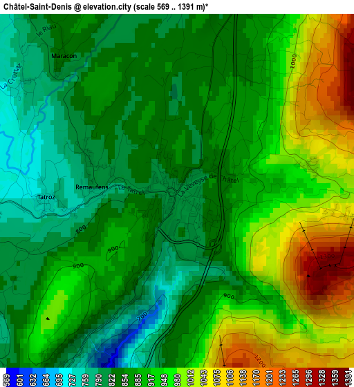
Below is the Elevation map of Châtel-Saint-Denis, which displays elevation range with different colors. Scale of the first map is from 569 to 1391 m (1867 to 4564 ft) with average elevation of 900.4 meters (=2954 ft) [note 1]
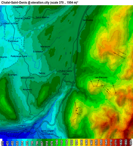
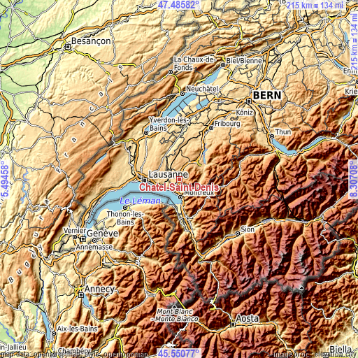
These maps also provides idea of topography and contour of this city, they are displayed at different zoom levels. More info about maps, scale and edge coordinates you can find below images.
| \ | Map #1 | Map #2 | Topo.Map |
| Scale [m] | 569..1391 m | 370..1954 m | × |
| Scale [ft] | 1867..4564 ft | 1214..6411 ft | × |
| Average | 900.4 m = 2954 ft | 958.5 m = 3145 ft | × |
| Width | 6.72 km = 4.2 mi | 13.45 km = 8.4 mi | 215.2 km = 133.7 mi |
| Height | 6.72 km = 4.2 mi | 13.45 km = 8.4 mi | 215.1 km = 133.7 mi |
| ↑Max Latitude | 46.557137° | 46.587346° | 47.48582° |
| Latitude at center | 46.52691° | 46.52691° | 46.52691° |
| ↓Min Latitude | 46.496667° | 46.466406° | 45.55077° |
| ← Min Longitude | 6.856885° | 6.812939° | 5.49458° |
| Longitude center | 6.90083° | 6.90083° | 6.90083° |
| →Max Longitude | 6.944775° | 6.988721° | 8.30708° |
Nearby cities:
Cities around Châtel-Saint-Denis sort by population:
• Montreux elevation 403 m
10.5 km,  175°
175°
• Vevey 388 m
8.4 km,  211°
211°
• La Tour-de-Peilz 387 m
8.8 km,  201°
201°
• Blonay 629 m
6.6 km, 183°
• Chardonne 592 m
7.9 km,  225°
225°
• Puidoux 660 m
9.5 km,  252°
252°
• Attalens 766 m
4.5 km,  238°
238°
• Jongny 625 m
7 km,  220°
220°
• Palézieux 684 m
5 km,  289°
289°
• Oron-la-Ville 629 m
7.6 km,  310°
310°
• Saint Saphorin 403 m
10 km, 233°
• St-Légier-La Chiésaz 569 m
6.4 km, 198°
Multilingual:
 En español:
Châtel-Saint-Denis elevación 809 m.
 En France:
Châtel-Saint-Denis élévation 809 m.
 Auf Deutsch:
Châtel-Saint-Denis höhe über dem Meeresspiegel ist 809 m.
 На русском:
Châtel-Saint-Denis высота над уровнем моря 809 м
Sources and notes:
- [note 1] Map square and city borders are not equal. Map elevation data is calculated only from area inside that square.
- [src 1] Elevation data from geonames database provided with same terms of usage.
- [src 2] The elevation map of Châtel-Saint-Denis is generated using elevation data from NASA's 3 arcsec (90m) resolution SRTM data.
- [src 3] Base (background) map © OpenStreetMap contributors tiles are generated by Geofabrik and OpenTopoMap.
Copyright & License:
This Châtel-Saint-Denis Elevation Map is licensed under CC BY-SA. You may reuse any part from this page, if you give a proper credit by linking to this URL:
 More info on terms of use page.