Cully elevation
Cully (Vaud, Lavaux-Oron District), Switzerland elevation is 392 meters and Cully elevation in feet is 1286 ft above sea level [src 1]. Cully is a seat of a second-order administrative division (feature code) with elevation that is 156 meters (512 ft) smaller than average city elevation in Switzerland.
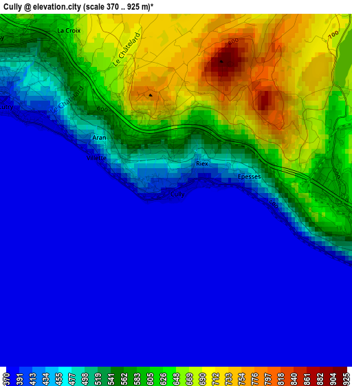
Below is the Elevation map of Cully, which displays elevation range with different colors. Scale of the first map is from 370 to 925 m (1214 to 3035 ft) with average elevation of 495.9 meters (=1627 ft) [note 1]
These maps also provides idea of topography and contour of this city, they are displayed at different zoom levels. More info about maps, scale and edge coordinates you can find below images.
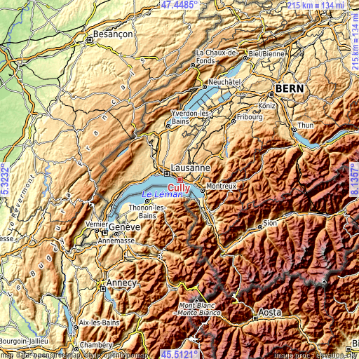
| \ | Map #1 | Topo.Map |
| Scale [m] | 370..925 m | × |
| Scale [ft] | 1214..3035 ft | × |
| Average | 495.9 m = 1627 ft | × |
| Width | 6.73 km = 4.2 mi | 215.3 km = 133.8 mi |
| Height | 6.73 km = 4.2 mi | 215.3 km = 133.8 mi |
| ↑Max Latitude | 46.519168° | 47.4485° |
| Latitude at center | 46.48892° | 46.48892° |
| ↓Min Latitude | 46.458655° | 45.5121° |
| ← Min Longitude | 6.685505° | 5.3232° |
| Longitude center | 6.72945° | 6.72945° |
| →Max Longitude | 6.773395° | 8.1357° |
Nearby cities:
Cities around Cully sort by population:
• Lausanne elevation 453 m
8 km,  292°
292°
• Pully 428 m
5.7 km, 294°
• Lutry 386 m
3.6 km, 294°
• Epalinges 782 m
8.2 km,  324°
324°
• Savigny 799 m
5.5 km,  2°
2°
• Belmont-sur-Lausanne 593 m
5.3 km,  309°
309°
• Chardonne 592 m
7.6 km,  100°
100°
• Puidoux 660 m
4.3 km,  71°
71°
• Chexbres 570 m
3.8 km, 101°
• Jongny 625 m
8.6 km, 97°
• Paudex 383 m
5 km, 291°
• Saint Saphorin 403 m
5.4 km,  108°
108°
Multilingual:
 En español:
Cully elevación 392 m.
 En France:
Cully élévation 392 m.
 Auf Deutsch:
Cully VD, Cully (VD) höhe über dem Meeresspiegel ist 392 m.

Sources and notes:
- [note 1] Map square and city borders are not equal. Map elevation data is calculated only from area inside that square.
- [src 1] Elevation data from geonames database provided with same terms of usage.
- [src 2] The elevation map of Cully is generated using elevation data from NASA's 3 arcsec (90m) resolution SRTM data.
- [src 3] Base (background) map © OpenStreetMap contributors tiles are generated by Geofabrik and OpenTopoMap.
Copyright & License:
This Cully Elevation Map is licensed under CC BY-SA. You may reuse any part from this page, if you give a proper credit by linking to this URL:
 More info on terms of use page.