Gebenstorf elevation
Gebenstorf (Aargau, Bezirk Baden), Switzerland elevation is 341 meters and Gebenstorf elevation in feet is 1119 ft above sea level [src 1]. Gebenstorf is a populated place (feature code) with elevation that is 207 meters (679 ft) smaller than average city elevation in Switzerland.
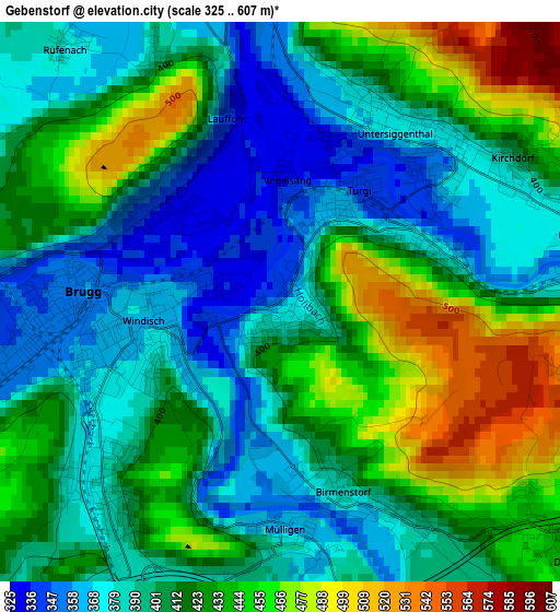
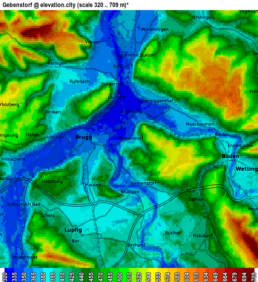
Below is the Elevation map of Gebenstorf, which displays elevation range with different colors. Scale of the first map is from 325 to 607 m (1066 to 1991 ft) with average elevation of 412.1 meters (=1352 ft) [note 1]
These maps also provides idea of topography and contour of this city, they are displayed at different zoom levels. More info about maps, scale and edge coordinates you can find below images.
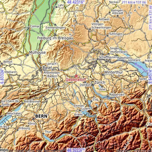
| \ | Map #1 | Map #2 | Topo.Map |
| Scale [m] | 325..607 m | 320..709 m | × |
| Scale [ft] | 1066..1991 ft | 1050..2326 ft | × |
| Average | 412.1 m = 1352 ft | 442.5 m = 1452 ft | × |
| Width | 6.6 km = 4.1 mi | 13.21 km = 8.2 mi | 211.3 km = 131.3 mi |
| Height | 6.6 km = 4.1 mi | 13.21 km = 8.2 mi | 211.3 km = 131.3 mi |
| ↑Max Latitude | 47.511051° | 47.540726° | 48.42316° |
| Latitude at center | 47.48136° | 47.48136° | 47.48136° |
| ↓Min Latitude | 47.451652° | 47.421927° | 46.52237° |
| ← Min Longitude | 8.195545° | 8.151599° | 6.83324° |
| Longitude center | 8.23949° | 8.23949° | 8.23949° |
| →Max Longitude | 8.283435° | 8.327381° | 9.64574° |
Nearby cities:
Cities around Gebenstorf sort by population:
• Baden elevation 418 m
5.1 km,  100°
100°
• Brugg 354 m
2.3 km,  268°
268°
• Obersiggenthal 392 m
4.3 km,  80°
80°
• Windisch 363 m
1.6 km,  260°
260°
• Untersiggenthal 385 m
2.6 km,  27°
27°
• Birr 395 m
5.7 km,  203°
203°
• Würenlingen 363 m
5.9 km,  12°
12°
• Turgi 341 m
1.6 km,  42°
42°
• Hausen 376 m
2.9 km,  228°
228°
• Birmenstorf 388 m
2.3 km,  163°
163°
• Lauffohr (Brugg) 336 m
2.3 km,  344°
344°
• Villigen 367 m
5.4 km, 339°
Multilingual:
 En español:
Gebenstorf elevación 341 m.
 En France:
Gebenstorf élévation 341 m.
 Auf Deutsch:
Gebenstorf höhe über dem Meeresspiegel ist 341 m.

Sources and notes:
- [note 1] Map square and city borders are not equal. Map elevation data is calculated only from area inside that square.
- [src 1] Elevation data from geonames database provided with same terms of usage.
- [src 2] The elevation map of Gebenstorf is generated using elevation data from NASA's 3 arcsec (90m) resolution SRTM data.
- [src 3] Base (background) map © OpenStreetMap contributors tiles are generated by Geofabrik and OpenTopoMap.
Copyright & License:
This Gebenstorf Elevation Map is licensed under CC BY-SA. You may reuse any part from this page, if you give a proper credit by linking to this URL:
 More info on terms of use page.