Ingenbohl elevation
Ingenbohl (Schwyz, Bezirk Schwyz), Switzerland elevation is 438 meters and Ingenbohl elevation in feet is 1437 ft above sea level [src 1]. Ingenbohl is a populated place (feature code) with elevation that is 110 meters (361 ft) smaller than average city elevation in Switzerland.
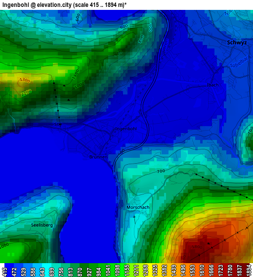
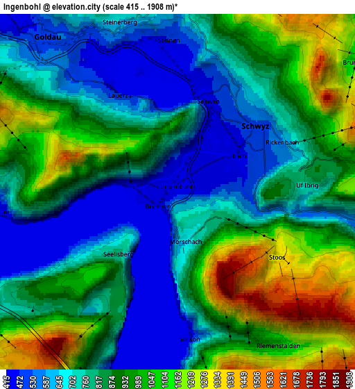
Below is the Elevation map of Ingenbohl, which displays elevation range with different colors. Scale of the first map is from 415 to 1894 m (1362 to 6214 ft) with average elevation of 690.8 meters (=2266 ft) [note 1]
These maps also provides idea of topography and contour of this city, they are displayed at different zoom levels. More info about maps, scale and edge coordinates you can find below images.
| \ | Map #1 | Map #2 | Topo.Map |
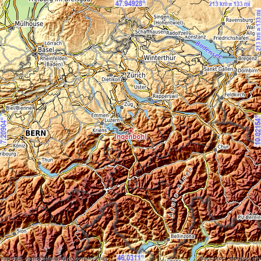
| Scale [m] | 415..1894 m | 415..1908 m | × |
| Scale [ft] | 1362..6214 ft | 1362..6260 ft | × |
| Average | 690.8 m = 2266 ft | 860.1 m = 2822 ft | × |
| Width | 6.66 km = 4.1 mi | 13.33 km = 8.3 mi | 213.3 km = 132.5 mi |
| Height | 6.67 km = 4.1 mi | 13.33 km = 8.3 mi | 213.3 km = 132.5 mi |
| ↑Max Latitude | 47.028763° | 47.058709° | 47.94928° |
| Latitude at center | 46.9988° | 46.9988° | 46.9988° |
| ↓Min Latitude | 46.96882° | 46.938824° | 46.0311° |
| ← Min Longitude | 8.571345° | 8.527399° | 7.20904° |
| Longitude center | 8.61529° | 8.61529° | 8.61529° |
| →Max Longitude | 8.659235° | 8.703181° | 10.02154° |
Nearby cities:
Cities around Ingenbohl sort by population:
• Schwyz elevation 521 m
3.8 km,  50°
50°
• Arth 425 m
10 km,  315°
315°
• Goldau 517 m
7.5 km, 316°
• Ibach 454 m
2.7 km,  59°
59°
• Beckenried 434 m
11.2 km,  251°
251°
• Steinen 477 m
5.7 km,  357°
357°
• Flüelen 431 m
10.5 km,  176°
176°
• Gersau 465 m
6.9 km,  265°
265°
• Sattel 811 m
9.4 km,  9°
9°
• Vitznau 448 m
10 km,  277°
277°
• Emmetten 761 m
9 km,  238°
238°
• Bauen 467 m
7.6 km,  201°
201°
Multilingual:
 En español:
Ingenbohl elevación 438 m.
 En France:
Ingenbohl élévation 438 m.
 Auf Deutsch:
Ingenbohl höhe über dem Meeresspiegel ist 438 m.

Sources and notes:
- [note 1] Map square and city borders are not equal. Map elevation data is calculated only from area inside that square.
- [src 1] Elevation data from geonames database provided with same terms of usage.
- [src 2] The elevation map of Ingenbohl is generated using elevation data from NASA's 3 arcsec (90m) resolution SRTM data.
- [src 3] Base (background) map © OpenStreetMap contributors tiles are generated by Geofabrik and OpenTopoMap.
Copyright & License:
This Ingenbohl Elevation Map is licensed under CC BY-SA. You may reuse any part from this page, if you give a proper credit by linking to this URL:
 More info on terms of use page.