Kirchberg elevation
Kirchberg (Bern, Emmental District), Switzerland elevation is 509 meters and Kirchberg elevation in feet is 1670 ft above sea level [src 1]. Kirchberg is a populated place (feature code) with elevation that is 39 meters (128 ft) smaller than average city elevation in Switzerland.
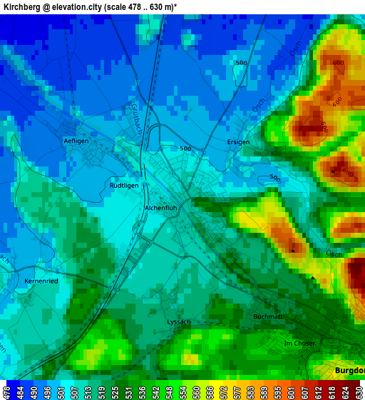
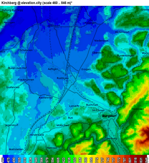
Below is the Elevation map of Kirchberg, which displays elevation range with different colors. Scale of the first map is from 478 to 630 m (1568 to 2067 ft) with average elevation of 518 meters (=1699 ft) [note 1]
These maps also provides idea of topography and contour of this city, they are displayed at different zoom levels. More info about maps, scale and edge coordinates you can find below images.
| \ | Map #1 | Map #2 | Topo.Map |
| Scale [m] | 478..630 m | 460..846 m | × |
| Scale [ft] | 1568..2067 ft | 1509..2776 ft | × |
| Average | 518 m = 1699 ft | 540 m = 1772 ft | × |
| Width | 6.65 km = 4.1 mi | 13.31 km = 8.3 mi | 212.9 km = 132.3 mi |
| Height | 6.65 km = 4.1 mi | 13.31 km = 8.3 mi | 212.9 km = 132.3 mi |
| ↑Max Latitude | 47.115294° | 47.145192° | 48.03431° |
| Latitude at center | 47.08538° | 47.08538° | 47.08538° |
| ↓Min Latitude | 47.055449° | 47.025501° | 46.11924° |
| ← Min Longitude | 7.538935° | 7.494989° | 6.17663° |
| Longitude center | 7.58288° | 7.58288° | 7.58288° |
| →Max Longitude | 7.626825° | 7.670771° | 8.98913° |
Nearby cities:
Cities around Kirchberg sort by population:
• Burgdorf elevation 535 m
4.5 km,  130°
130°
• Utzenstorf 473 m
5.7 km,  337°
337°
• Oberburg 551 m
6.4 km,  148°
148°
• Bätterkinden 474 m
6.2 km,  326°
326°
• Wynigen 532 m
6.7 km,  70°
70°
• Hindelbank 523 m
5.7 km,  213°
213°
• Koppigen 482 m
5.4 km,  18°
18°
• Fraubrunnen 495 m
4.2 km,  271°
271°
• Heimiswil 640 m
6.6 km,  107°
107°
• Ersigen 499 m
1.3 km,  44°
44°
• Lyssach 519 m
2.3 km,  181°
181°
• Rüti bei Lyssach 541 m
3.2 km,  188°
188°
Multilingual:
 En español:
Kirchberg elevación 509 m.
 En France:
Kirchberg élévation 509 m.
 Auf Deutsch:
Kirchberg BE höhe über dem Meeresspiegel ist 509 m.

Sources and notes:
- [note 1] Map square and city borders are not equal. Map elevation data is calculated only from area inside that square.
- [src 1] Elevation data from geonames database provided with same terms of usage.
- [src 2] The elevation map of Kirchberg is generated using elevation data from NASA's 3 arcsec (90m) resolution SRTM data.
- [src 3] Base (background) map © OpenStreetMap contributors tiles are generated by Geofabrik and OpenTopoMap.
Copyright & License:
This Kirchberg Elevation Map is licensed under CC BY-SA. You may reuse any part from this page, if you give a proper credit by linking to this URL:
 More info on terms of use page.