Zürich (Kreis 11) / Oerlikon elevation
Zürich (Kreis 11) / Oerlikon (Zurich, Bezirk Zürich), Switzerland elevation is 459 meters and Zürich (Kreis 11) / Oerlikon elevation in feet is 1506 ft above sea level [src 1]. Zürich (Kreis 11) / Oerlikon is a section of populated place (feature code) with elevation that is 89 meters (292 ft) smaller than average city elevation in Switzerland.
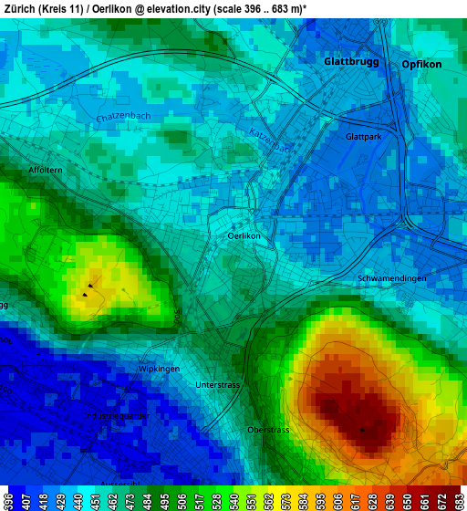
Below is the Elevation map of Zürich (Kreis 11) / Oerlikon, which displays elevation range with different colors. Scale of the first map is from 396 to 683 m (1299 to 2241 ft) with average elevation of 469.3 meters (=1540 ft) [note 1]
These maps also provides idea of topography and contour of this city, they are displayed at different zoom levels. More info about maps, scale and edge coordinates you can find below images.
| \ | Map #1 | Map #2 | Topo.Map |
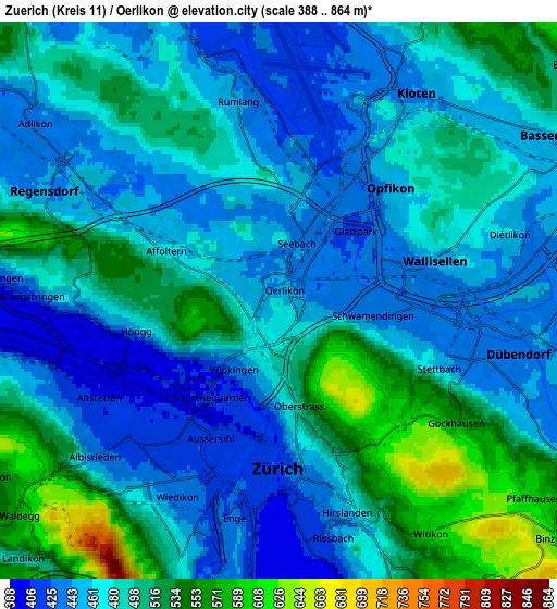
| Scale [m] | 396..683 m | 388..864 m | × |
| Scale [ft] | 1299..2241 ft | 1273..2835 ft | × |
| Average | 469.3 m = 1540 ft | 481.3 m = 1579 ft | × |
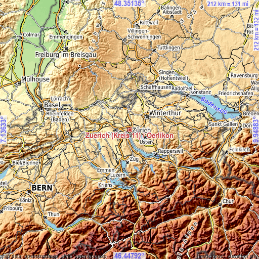
| Width | 6.61 km = 4.1 mi | 13.23 km = 8.2 mi | 211.6 km = 131.5 mi |
| Height | 6.61 km = 4.1 mi | 13.23 km = 8.2 mi | 211.6 km = 131.5 mi |
| ↑Max Latitude | 47.437962° | 47.467678° | 48.35135° |
| Latitude at center | 47.40823° | 47.40823° | 47.40823° |
| ↓Min Latitude | 47.378481° | 47.348715° | 46.44792° |
| ← Min Longitude | 8.498635° | 8.454689° | 7.13633° |
| Longitude center | 8.54258° | 8.54258° | 8.54258° |
| →Max Longitude | 8.586525° | 8.630471° | 9.94883° |
Nearby cities:
Cities around Zürich (Kreis 11) / Oerlikon sort by population:
• Zürich (Kreis 11) elevation 445 m
2.3 km,  316°
316°
• Zürich (Kreis 6) 487 m
1.8 km,  177°
177°
• Zürich (Kreis 12) 435 m
2.6 km,  101°
101°
• Zürich (Kreis 6) / Unterstrass 476 m
1.5 km,  195°
195°
• Zürich (Kreis 11) / Seebach 436 m
1.6 km,  14°
14°
• Zürich (Kreis 11) / Affoltern 466 m
2.5 km,  295°
295°
• Zürich (Kreis 10) / Wipkingen 434 m
2 km,  221°
221°
• Zürich (Kreis 12) / Schwamendingen-Mitte 431 m
2.3 km, 95°
• Zürich (Kreis 6) / Oberstrass 527 m
2.2 km,  164°
164°
• Zürich (Kreis 12) / Saatlen 430 m
1.7 km,  78°
78°
• Zürich (Kreis 11) / Schwandenholz 441 m
2.4 km, 318°
• Zürich (Kreis 12) / Auzelg 430 m
2.2 km,  69°
69°
Multilingual:
 En español:
Zürich (Kreis 11) / Oerlikon elevación 459 m.
 En France:
Zürich (Kreis 11) / Oerlikon élévation 459 m.
 Auf Deutsch:
Zürich (Kreis 11) / Oerlikon höhe über dem Meeresspiegel ist 459 m.
 На русском:
Zürich (Kreis 11) / Oerlikon высота над уровнем моря 459 м
Sources and notes:
- [note 1] Map square and city borders are not equal. Map elevation data is calculated only from area inside that square.
- [src 1] Elevation data from geonames database provided with same terms of usage.
- [src 2] The elevation map of Zürich (Kreis 11) / Oerlikon is generated using elevation data from NASA's 3 arcsec (90m) resolution SRTM data.
- [src 3] Base (background) map © OpenStreetMap contributors tiles are generated by Geofabrik and OpenTopoMap.
Copyright & License:
This Zürich (Kreis 11) / Oerlikon Elevation Map is licensed under CC BY-SA. You may reuse any part from this page, if you give a proper credit by linking to this URL:
 More info on terms of use page.