Richterswil elevation
Richterswil (Zurich, Bezirk Horgen), Switzerland elevation is 482 meters and Richterswil elevation in feet is 1581 ft above sea level [src 1]. Richterswil is a populated place (feature code) with elevation that is 66 meters (217 ft) smaller than average city elevation in Switzerland.
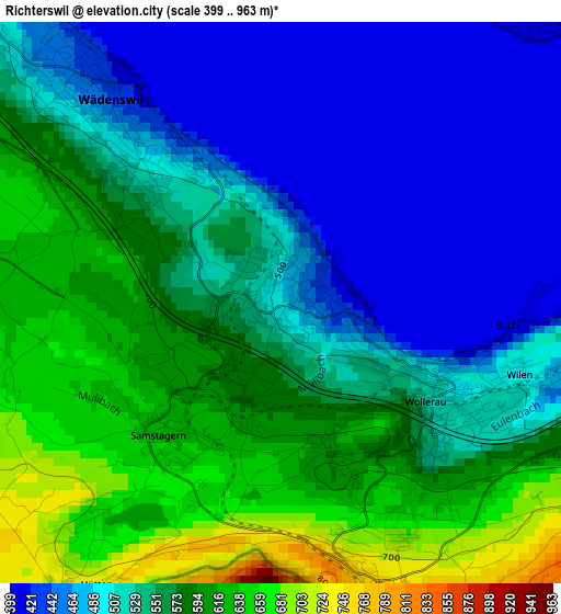
Below is the Elevation map of Richterswil, which displays elevation range with different colors. Scale of the first map is from 399 to 963 m (1309 to 3159 ft) with average elevation of 541 meters (=1775 ft) [note 1]
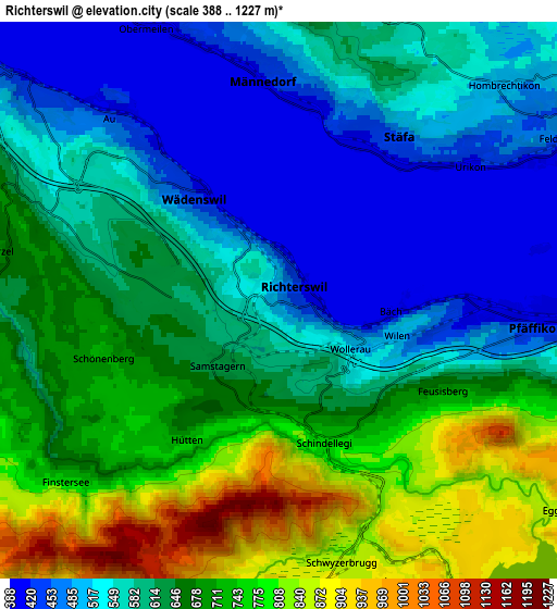
These maps also provides idea of topography and contour of this city, they are displayed at different zoom levels. More info about maps, scale and edge coordinates you can find below images.
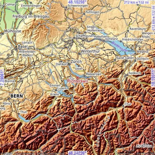
| \ | Map #1 | Map #2 | Topo.Map |
| Scale [m] | 399..963 m | 388..1227 m | × |
| Scale [ft] | 1309..3159 ft | 1273..4026 ft | × |
| Average | 541 m = 1775 ft | 625.8 m = 2053 ft | × |
| Width | 6.64 km = 4.1 mi | 13.28 km = 8.3 mi | 212.5 km = 132 mi |
| Height | 6.64 km = 4.1 mi | 13.28 km = 8.3 mi | 212.4 km = 132 mi |
| ↑Max Latitude | 47.236066° | 47.265896° | 48.15298° |
| Latitude at center | 47.20622° | 47.20622° | 47.20622° |
| ↓Min Latitude | 47.176357° | 47.146477° | 46.24226° |
| ← Min Longitude | 8.652915° | 8.608969° | 7.29061° |
| Longitude center | 8.69686° | 8.69686° | 8.69686° |
| →Max Longitude | 8.740805° | 8.784751° | 10.10311° |
Nearby cities:
Cities around Richterswil sort by population:
• Wädenswil elevation 450 m
3.1 km,  317°
317°
• Wollerau 520 m
2.1 km,  127°
127°
• Richterswil / Richterswil (Dorfkern) 441 m
0.7 km,  117°
117°
• Samstagern 628 m
2 km,  214°
214°
• Wädenswil / Dorf (Wädenswil) 417 m
3.2 km, 323°
• Wädenswil / Untermosen-Fuhr 476 m
3.5 km,  313°
313°
• Wädenswil / Leihof-Mühlebach 481 m
2.7 km, 315°
• Wädenswil / Boller-Giessen 453 m
1.9 km,  329°
329°
• Bäch 409 m
2.7 km,  95°
95°
• Wädenswil / Eichweid 526 m
2.2 km, 308°
• Richterswil / Dorfkern 414 m
0.7 km,  81°
81°
• Richterswil / Burghalde 542 m
0.6 km, 313°
Multilingual:
 En español:
Richterswil elevación 482 m.
 En France:
Richterswil élévation 482 m.
 Auf Deutsch:
Richterswil höhe über dem Meeresspiegel ist 482 m.

Sources and notes:
- [note 1] Map square and city borders are not equal. Map elevation data is calculated only from area inside that square.
- [src 1] Elevation data from geonames database provided with same terms of usage.
- [src 2] The elevation map of Richterswil is generated using elevation data from NASA's 3 arcsec (90m) resolution SRTM data.
- [src 3] Base (background) map © OpenStreetMap contributors tiles are generated by Geofabrik and OpenTopoMap.
Copyright & License:
This Richterswil Elevation Map is licensed under CC BY-SA. You may reuse any part from this page, if you give a proper credit by linking to this URL:
 More info on terms of use page.