Sierre elevation
Sierre (Valais, Sierre District), Switzerland elevation is 528 meters and Sierre elevation in feet is 1732 ft above sea level [src 1]. Sierre is a seat of a second-order administrative division (feature code) with elevation that is 20 meters (66 ft) smaller than average city elevation in Switzerland.
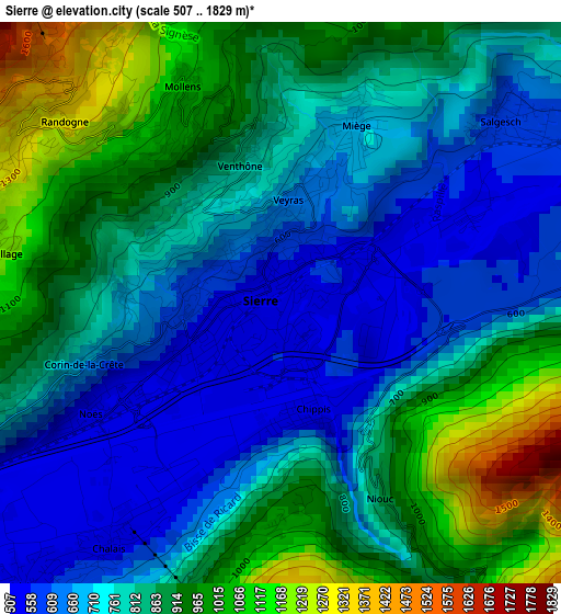
Below is the Elevation map of Sierre, which displays elevation range with different colors. Scale of the first map is from 507 to 1829 m (1663 to 6001 ft) with average elevation of 811.8 meters (=2663 ft) [note 1]
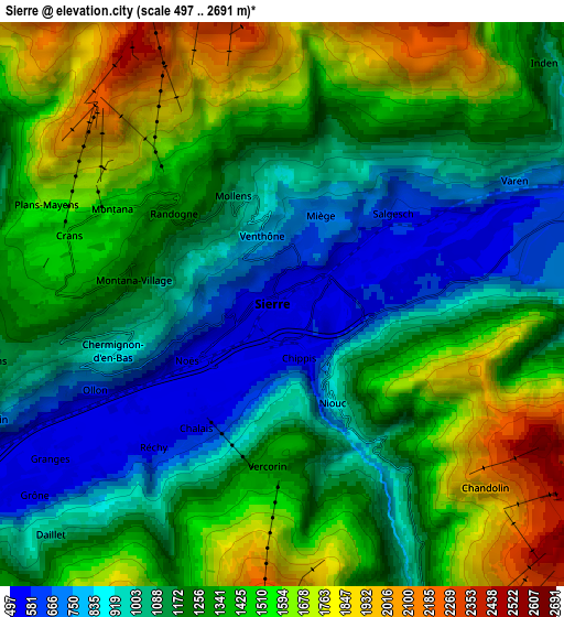
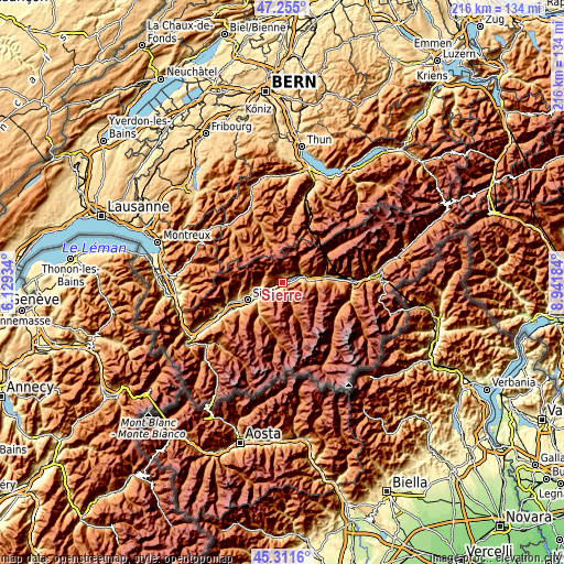
These maps also provides idea of topography and contour of this city, they are displayed at different zoom levels. More info about maps, scale and edge coordinates you can find below images.
| \ | Map #1 | Map #2 | Topo.Map |
| Scale [m] | 507..1829 m | 497..2691 m | × |
| Scale [ft] | 1663..6001 ft | 1631..8829 ft | × |
| Average | 811.8 m = 2663 ft | 1268.8 m = 4163 ft | × |
| Width | 6.75 km = 4.2 mi | 13.51 km = 8.4 mi | 216.1 km = 134.3 mi |
| Height | 6.75 km = 4.2 mi | 13.51 km = 8.4 mi | 216.1 km = 134.3 mi |
| ↑Max Latitude | 46.322277° | 46.352617° | 47.255° |
| Latitude at center | 46.29192° | 46.29192° | 46.29192° |
| ↓Min Latitude | 46.261546° | 46.231155° | 45.3116° |
| ← Min Longitude | 7.491645° | 7.447699° | 6.12934° |
| Longitude center | 7.53559° | 7.53559° | 7.53559° |
| →Max Longitude | 7.579535° | 7.623481° | 8.94184° |
Nearby cities:
Cities around Sierre sort by population:
• Lens elevation 1177 m
6.7 km,  261°
261°
• Leuk 744 m
8.1 km,  69°
69°
• Ayent 1057 m
9.7 km, 263°
• Randogne 1236 m
3.3 km,  306°
306°
• Chermignon-d’en Haut 1149 m
4.7 km,  265°
265°
• Chalais 512 m
3.3 km,  214°
214°
• Montana 1495 m
4.3 km,  303°
303°
• Grône 503 m
7.3 km,  233°
233°
• Chippis 531 m
1.3 km,  166°
166°
• Salgesch 583 m
3.5 km,  51°
51°
• Varen 759 m
6.3 km,  61°
61°
• Veyras 651 m
1.1 km,  2°
2°
Multilingual:
 En español:
Sierre elevación 528 m.
 En France:
Sierre élévation 528 m.


Sources and notes:
- [note 1] Map square and city borders are not equal. Map elevation data is calculated only from area inside that square.
- [src 1] Elevation data from geonames database provided with same terms of usage.
- [src 2] The elevation map of Sierre is generated using elevation data from NASA's 3 arcsec (90m) resolution SRTM data.
- [src 3] Base (background) map © OpenStreetMap contributors tiles are generated by Geofabrik and OpenTopoMap.
Copyright & License:
This Sierre Elevation Map is licensed under CC BY-SA. You may reuse any part from this page, if you give a proper credit by linking to this URL:
 More info on terms of use page.