Thalwil elevation
Thalwil (Zurich, Bezirk Horgen), Switzerland elevation is 468 meters and Thalwil elevation in feet is 1535 ft above sea level [src 1]. Thalwil is a populated place (feature code) with elevation that is 80 meters (262 ft) smaller than average city elevation in Switzerland.
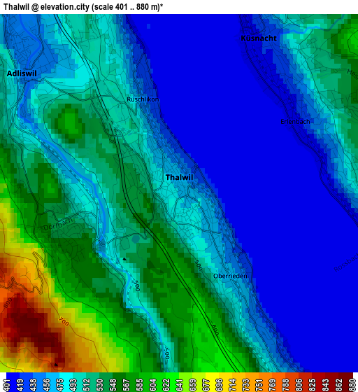
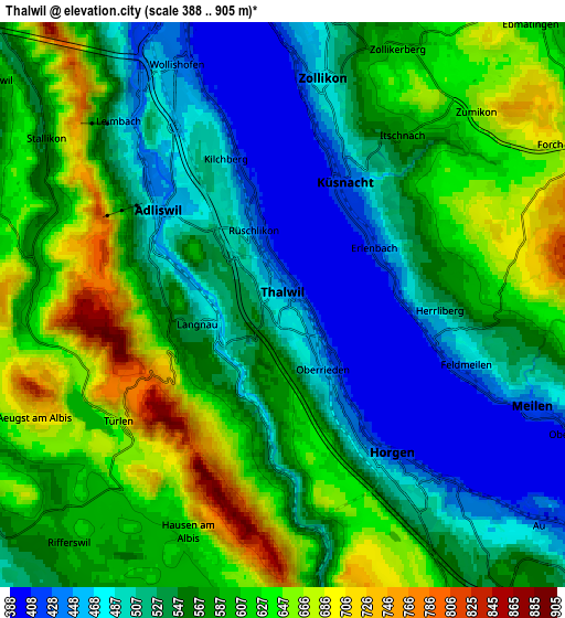
Below is the Elevation map of Thalwil, which displays elevation range with different colors. Scale of the first map is from 401 to 880 m (1316 to 2887 ft) with average elevation of 498 meters (=1634 ft) [note 1]
These maps also provides idea of topography and contour of this city, they are displayed at different zoom levels. More info about maps, scale and edge coordinates you can find below images.
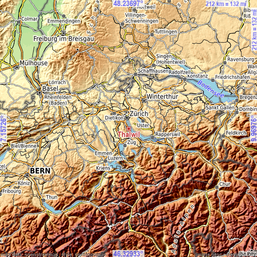
| \ | Map #1 | Map #2 | Topo.Map |
| Scale [m] | 401..880 m | 388..905 m | × |
| Scale [ft] | 1316..2887 ft | 1273..2969 ft | × |
| Average | 498 m = 1634 ft | 565.5 m = 1855 ft | × |
| Width | 6.63 km = 4.1 mi | 13.26 km = 8.2 mi | 212.1 km = 131.8 mi |
| Height | 6.63 km = 4.1 mi | 13.26 km = 8.2 mi | 212.1 km = 131.8 mi |
| ↑Max Latitude | 47.321548° | 47.35133° | 48.23697° |
| Latitude at center | 47.29175° | 47.29175° | 47.29175° |
| ↓Min Latitude | 47.261935° | 47.232103° | 46.32933° |
| ← Min Longitude | 8.519565° | 8.475619° | 7.15726° |
| Longitude center | 8.56351° | 8.56351° | 8.56351° |
| →Max Longitude | 8.607455° | 8.651401° | 9.96976° |
Nearby cities:
Cities around Thalwil sort by population:
• Langnau am Albis elevation 485 m
1.7 km,  259°
259°
• Thalwil / Dorfkern 470 m
0.3 km,  123°
123°
• Langnau / Langnau (Dorf) 530 m
2.1 km,  253°
253°
• Rüschlikon 478 m
1.9 km,  331°
331°
• Oberrieden 464 m
2.2 km,  149°
149°
• Gattikon 507 m
1.4 km,  234°
234°
• Oberrieden / Berg 479 m
1.9 km,  158°
158°
• Thalwil / See 423 m
0.5 km,  59°
59°
• Thalwil / Nord 470 m
0.8 km,  319°
319°
• Thalwil / Berg 521 m
0.6 km,  270°
270°
• Thalwil / Süd 470 m
0.9 km, 148°
• Langnau / Vitaquartier 474 m
2 km,  276°
276°
Multilingual:
 En español:
Thalwil elevación 468 m.
 En France:
Thalwil élévation 468 m.


Sources and notes:
- [note 1] Map square and city borders are not equal. Map elevation data is calculated only from area inside that square.
- [src 1] Elevation data from geonames database provided with same terms of usage.
- [src 2] The elevation map of Thalwil is generated using elevation data from NASA's 3 arcsec (90m) resolution SRTM data.
- [src 3] Base (background) map © OpenStreetMap contributors tiles are generated by Geofabrik and OpenTopoMap.
Copyright & License:
This Thalwil Elevation Map is licensed under CC BY-SA. You may reuse any part from this page, if you give a proper credit by linking to this URL:
 More info on terms of use page.