Uerikon elevation
Uerikon (Zurich, Bezirk Meilen), Switzerland elevation is 420 meters and Uerikon elevation in feet is 1378 ft above sea level [src 1]. Uerikon is a populated place (feature code) with elevation that is 128 meters (420 ft) smaller than average city elevation in Switzerland.
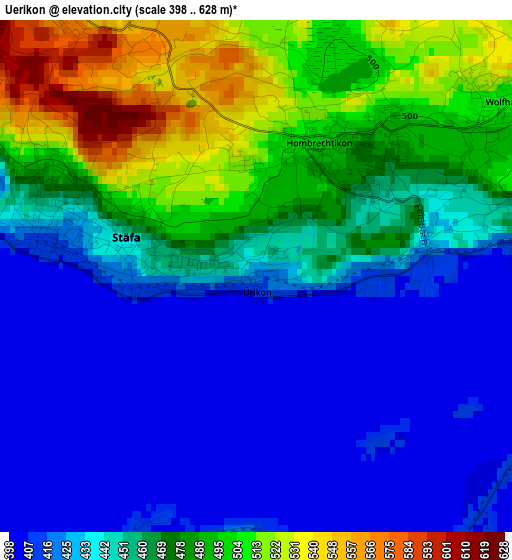
Below is the Elevation map of Uerikon, which displays elevation range with different colors. Scale of the first map is from 398 to 628 m (1306 to 2060 ft) with average elevation of 453.8 meters (=1489 ft) [note 1]
These maps also provides idea of topography and contour of this city, they are displayed at different zoom levels. More info about maps, scale and edge coordinates you can find below images.
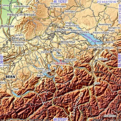
| \ | Map #1 | Topo.Map |
| Scale [m] | 398..628 m | × |
| Scale [ft] | 1306..2060 ft | × |
| Average | 453.8 m = 1489 ft | × |
| Width | 6.64 km = 4.1 mi | 212.3 km = 131.9 mi |
| Height | 6.64 km = 4.1 mi | 212.3 km = 131.9 mi |
| ↑Max Latitude | 47.266549° | 48.18293° |
| Latitude at center | 47.23672° | 47.23672° |
| ↓Min Latitude | 47.206874° | 46.27331° |
| ← Min Longitude | 8.713355° | 7.35105° |
| Longitude center | 8.7573° | 8.7573° |
| →Max Longitude | 8.801245° | 10.16355° |
Nearby cities:
Cities around Uerikon sort by population:
• Rapperswil elevation 408 m
5.1 km,  104°
104°
• Freienbach 410 m
3.5 km,  178°
178°
• Männedorf 460 m
4.9 km,  296°
296°
• Pfäffikon 420 m
4.3 km,  158°
158°
• Stäfa 425 m
2.6 km,  284°
284°
• Oetwil 539 m
4.7 km,  323°
323°
• Hombrechtikon 496 m
2.1 km,  31°
31°
• Wolfhausen 505 m
3.8 km,  55°
55°
• Binzikon 502 m
4.4 km,  1°
1°
• Bäch 409 m
4.1 km,  207°
207°
• Dorf 436 m
1.7 km, 278°
• Männedorf / Ausserfeld 409 m
4 km,  285°
285°
Multilingual:
 En español:
Uerikon elevación 420 m.
 En France:
Uerikon élévation 420 m.


Sources and notes:
- [note 1] Map square and city borders are not equal. Map elevation data is calculated only from area inside that square.
- [src 1] Elevation data from geonames database provided with same terms of usage.
- [src 2] The elevation map of Uerikon is generated using elevation data from NASA's 3 arcsec (90m) resolution SRTM data.
- [src 3] Base (background) map © OpenStreetMap contributors tiles are generated by Geofabrik and OpenTopoMap.
Copyright & License:
This Uerikon Elevation Map is licensed under CC BY-SA. You may reuse any part from this page, if you give a proper credit by linking to this URL:
 More info on terms of use page.