Viganello elevation
Viganello (Ticino, Lugano District), Switzerland elevation is 301 meters and Viganello elevation in feet is 988 ft above sea level [src 1]. Viganello is a populated place (feature code) with elevation that is 247 meters (810 ft) smaller than average city elevation in Switzerland.
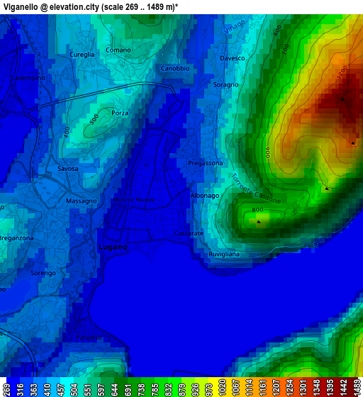
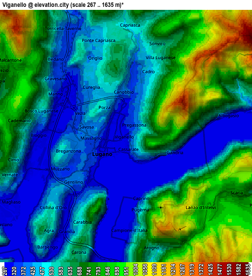
Below is the Elevation map of Viganello, which displays elevation range with different colors. Scale of the first map is from 269 to 1489 m (883 to 4885 ft) with average elevation of 474 meters (=1555 ft) [note 1]
These maps also provides idea of topography and contour of this city, they are displayed at different zoom levels. More info about maps, scale and edge coordinates you can find below images.
| \ | Map #1 | Map #2 | Topo.Map |
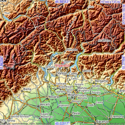
| Scale [m] | 269..1489 m | 267..1635 m | × |
| Scale [ft] | 883..4885 ft | 876..5364 ft | × |
| Average | 474 m = 1555 ft | 620.2 m = 2035 ft | × |
| Width | 6.79 km = 4.2 mi | 13.57 km = 8.4 mi | 217.2 km = 135 mi |
| Height | 6.79 km = 4.2 mi | 13.57 km = 8.4 mi | 217.2 km = 135 mi |
| ↑Max Latitude | 46.043931° | 46.074425° | 46.98143° |
| Latitude at center | 46.01342° | 46.01342° | 46.01342° |
| ↓Min Latitude | 45.982892° | 45.952347° | 45.02817° |
| ← Min Longitude | 8.924845° | 8.880899° | 7.56254° |
| Longitude center | 8.96879° | 8.96879° | 8.96879° |
| →Max Longitude | 9.012735° | 9.056681° | 10.37504° |
Nearby cities:
Cities around Viganello sort by population:
• Lugano elevation 284 m
0.8 km,  241°
241°
• Pregassona 373 m
0.9 km,  29°
29°
• Massagno 375 m
2 km,  267°
267°
• Montagnola 473 m
5.2 km,  229°
229°
• Canobbio 411 m
2.5 km,  355°
355°
• Bioggio 291 m
4.5 km, 270°
• Comano 505 m
2.8 km,  337°
337°
• Sorengo 375 m
3 km, 233°
• Cadro 485 m
3.9 km,  21°
21°
• Cadempino 319 m
3.7 km,  313°
313°
• Gravesano 368 m
5 km, 309°
• Savosa 387 m
2.1 km,  286°
286°
Multilingual:
 En español:
Viganello elevación 301 m.
 En France:
Viganello élévation 301 m.
 Auf Deutsch:
Viganello höhe über dem Meeresspiegel ist 301 m.

Sources and notes:
- [note 1] Map square and city borders are not equal. Map elevation data is calculated only from area inside that square.
- [src 1] Elevation data from geonames database provided with same terms of usage.
- [src 2] The elevation map of Viganello is generated using elevation data from NASA's 3 arcsec (90m) resolution SRTM data.
- [src 3] Base (background) map © OpenStreetMap contributors tiles are generated by Geofabrik and OpenTopoMap.
Copyright & License:
This Viganello Elevation Map is licensed under CC BY-SA. You may reuse any part from this page, if you give a proper credit by linking to this URL:
 More info on terms of use page.