Wetzikon elevation
Wetzikon (Zurich, Bezirk Hinwil), Switzerland elevation is 539 meters and Wetzikon elevation in feet is 1768 ft above sea level [src 1]. Wetzikon is a populated place (feature code) with elevation that is 9 meters (30 ft) smaller than average city elevation in Switzerland.
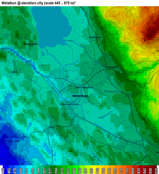
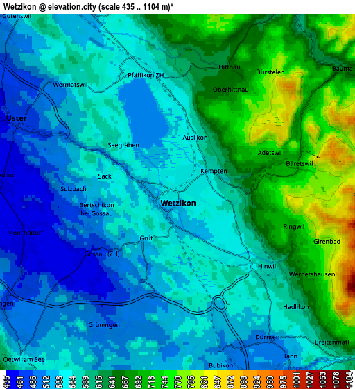
Below is the Elevation map of Wetzikon, which displays elevation range with different colors. Scale of the first map is from 445 to 875 m (1460 to 2871 ft) with average elevation of 569.7 meters (=1869 ft) [note 1]
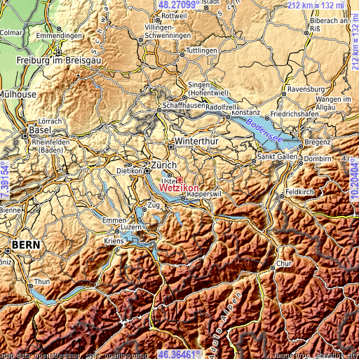
These maps also provides idea of topography and contour of this city, they are displayed at different zoom levels. More info about maps, scale and edge coordinates you can find below images.
| \ | Map #1 | Map #2 | Topo.Map |
| Scale [m] | 445..875 m | 435..1104 m | × |
| Scale [ft] | 1460..2871 ft | 1427..3622 ft | × |
| Average | 569.7 m = 1869 ft | 591.2 m = 1940 ft | × |
| Width | 6.62 km = 4.1 mi | 13.25 km = 8.2 mi | 212 km = 131.7 mi |
| Height | 6.62 km = 4.1 mi | 13.25 km = 8.2 mi | 212 km = 131.7 mi |
| ↑Max Latitude | 47.356179° | 47.385941° | 48.27099° |
| Latitude at center | 47.3264° | 47.3264° | 47.3264° |
| ↓Min Latitude | 47.296605° | 47.266792° | 46.36461° |
| ← Min Longitude | 8.753845° | 8.709899° | 7.39154° |
| Longitude center | 8.79779° | 8.79779° | 8.79779° |
| →Max Longitude | 8.841735° | 8.885681° | 10.20404° |
Nearby cities:
Cities around Wetzikon sort by population:
• Pfäffikon elevation 557 m
4.3 km,  354°
354°
• Pfäffikon / Pfäffikon (Dorfkern) 549 m
4.9 km, 346°
• Hinwil 573 m
5 km,  135°
135°
• Wetzikon / Kempten 561 m
1.2 km,  50°
50°
• Gossau 473 m
3.8 km,  231°
231°
• Wetzikon / Ober-Wetzikon 545 m
0.2 km,  129°
129°
• Wetzikon / Unter-Wetzikon 532 m
1.2 km,  195°
195°
• Wetzikon / Robenhausen 540 m
0.9 km,  303°
303°
• Pfäffikon / Irgenhausen 557 m
4 km, 354°
• Grüt 555 m
2 km,  213°
213°
• Hittnau / Hittnau (Dorf) 663 m
4.6 km,  25°
25°
• Bäretswil 702 m
4.6 km,  74°
74°
Multilingual:
 En español:
Wetzikon elevación 539 m.
 En France:
Wetzikon élévation 539 m.
 Auf Deutsch:
Wetzikon ZH höhe über dem Meeresspiegel ist 539 m.

Sources and notes:
- [note 1] Map square and city borders are not equal. Map elevation data is calculated only from area inside that square.
- [src 1] Elevation data from geonames database provided with same terms of usage.
- [src 2] The elevation map of Wetzikon is generated using elevation data from NASA's 3 arcsec (90m) resolution SRTM data.
- [src 3] Base (background) map © OpenStreetMap contributors tiles are generated by Geofabrik and OpenTopoMap.
Copyright & License:
This Wetzikon Elevation Map is licensed under CC BY-SA. You may reuse any part from this page, if you give a proper credit by linking to this URL:
 More info on terms of use page.