Zollikon elevation
Zollikon (Zurich, Bezirk Meilen), Switzerland elevation is 469 meters and Zollikon elevation in feet is 1539 ft above sea level [src 1]. Zollikon is a populated place (feature code) with elevation that is 79 meters (259 ft) smaller than average city elevation in Switzerland.
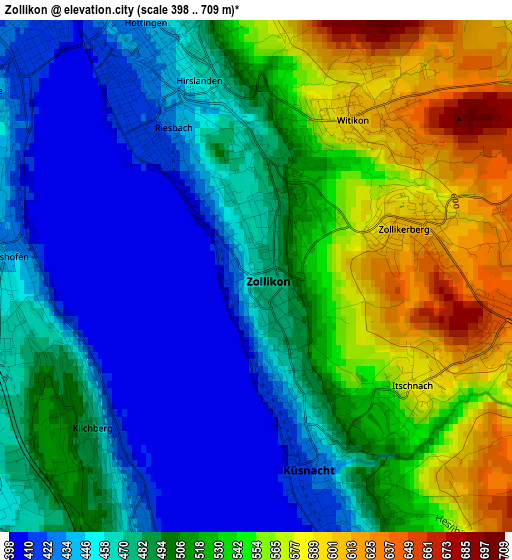
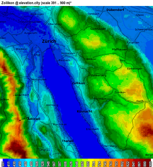
Below is the Elevation map of Zollikon, which displays elevation range with different colors. Scale of the first map is from 398 to 709 m (1306 to 2326 ft) with average elevation of 497.7 meters (=1633 ft) [note 1]
These maps also provides idea of topography and contour of this city, they are displayed at different zoom levels. More info about maps, scale and edge coordinates you can find below images.
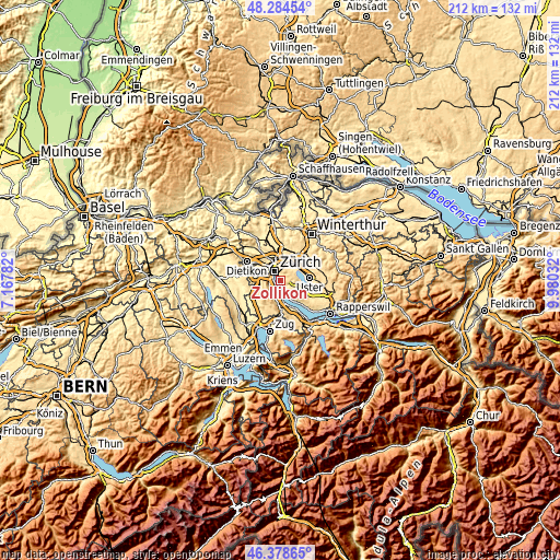
| \ | Map #1 | Map #2 | Topo.Map |
| Scale [m] | 398..709 m | 391..900 m | × |
| Scale [ft] | 1306..2326 ft | 1283..2953 ft | × |
| Average | 497.7 m = 1633 ft | 533.9 m = 1752 ft | × |
| Width | 6.62 km = 4.1 mi | 13.24 km = 8.2 mi | 211.9 km = 131.7 mi |
| Height | 6.62 km = 4.1 mi | 13.24 km = 8.2 mi | 211.9 km = 131.7 mi |
| ↑Max Latitude | 47.369961° | 47.399715° | 48.28454° |
| Latitude at center | 47.34019° | 47.34019° | 47.34019° |
| ↓Min Latitude | 47.310402° | 47.280598° | 46.37865° |
| ← Min Longitude | 8.530125° | 8.486179° | 7.16782° |
| Longitude center | 8.57407° | 8.57407° | 8.57407° |
| →Max Longitude | 8.618015° | 8.661961° | 9.98032° |
Nearby cities:
Cities around Zollikon sort by population:
• Zürich (Kreis 8) elevation 430 m
1.9 km,  328°
328°
• Küsnacht 427 m
2.6 km,  163°
163°
• Zürich (Kreis 7) / Witikon 599 m
2.3 km,  33°
33°
• Zürich (Kreis 7) / Hirslanden 469 m
2.5 km,  348°
348°
• Zürich (Kreis 8) / Mühlebach 425 m
2.3 km, 326°
• Zürich (Kreis 8) / Seefeld 415 m
2.1 km,  318°
318°
• Zürich (Kreis 8) / Weinegg 472 m
1.4 km, 347°
• Zollikerberg 614 m
2.1 km,  74°
74°
• Küsnacht / Goldbach 468 m
1.5 km, 160°
• Küsnacht / Itschnach 584 m
2.5 km,  125°
125°
• Küsnacht / Dorf 420 m
2.6 km, 164°
• Küsnacht / Schiedhalden 496 m
2.4 km,  152°
152°
Multilingual:
 En español:
Zollikon elevación 469 m.
 En France:
Zollikon élévation 469 m.
 Auf Deutsch:
Zollikon höhe über dem Meeresspiegel ist 469 m.

Sources and notes:
- [note 1] Map square and city borders are not equal. Map elevation data is calculated only from area inside that square.
- [src 1] Elevation data from geonames database provided with same terms of usage.
- [src 2] The elevation map of Zollikon is generated using elevation data from NASA's 3 arcsec (90m) resolution SRTM data.
- [src 3] Base (background) map © OpenStreetMap contributors tiles are generated by Geofabrik and OpenTopoMap.
Copyright & License:
This Zollikon Elevation Map is licensed under CC BY-SA. You may reuse any part from this page, if you give a proper credit by linking to this URL:
 More info on terms of use page.