Ouadda elevation
Ouadda (Haute-Kotto), Central African Republic elevation is 710 meters and Ouadda elevation in feet is 2329 ft above sea level [src 1]. Ouadda is a populated place (feature code) with elevation that is 205 meters (673 ft) bigger than average city elevation in Central African Republic.
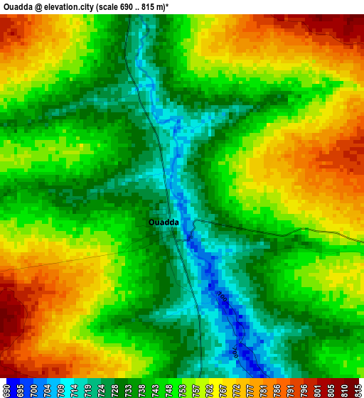
Below is the Elevation map of Ouadda, which displays elevation range with different colors. Scale of the first map is from 690 to 815 m (2264 to 2674 ft) with average elevation of 748.7 meters (=2456 ft) [note 1]
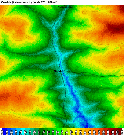
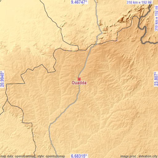
These maps also provides idea of topography and contour of this city, they are displayed at different zoom levels. More info about maps, scale and edge coordinates you can find below images.
| \ | Map #1 | Map #2 | Topo.Map |
| Scale [m] | 690..815 m | 678..870 m | × |
| Scale [ft] | 2264..2674 ft | 2224..2854 ft | × |
| Average | 748.7 m = 2456 ft | 772.2 m = 2533 ft | × |
| Width | 9.68 km = 6 mi | 19.35 km = 12 mi | 309.6 km = 192.4 mi |
| Height | 9.68 km = 6 mi | 19.35 km = 12 mi | 309.6 km = 192.4 mi |
| ↑Max Latitude | 8.121217° | 8.164719° | 9.46747° |
| Latitude at center | 8.07771° | 8.07771° | 8.07771° |
| ↓Min Latitude | 8.034198° | 7.990682° | 6.68315° |
| ← Min Longitude | 22.356805° | 22.312859° | 20.9945° |
| Longitude center | 22.40075° | 22.40075° | 22.40075° |
| →Max Longitude | 22.444695° | 22.488641° | 23.807° |
Nearby cities:
Cities around Ouadda sort by population:
• Kaga Bandoro elevation 416 m
374.3 km,  251°
251°
• Bambari 465 m
319.7 km,  216°
216°
• Bria 572 m
176.7 km,  194°
194°
• Bangassou 506 m
373.8 km,  172°
172°
• Ippy 596 m
239.4 km,  212°
212°
• Alindao 441 m
363.9 km,  201°
201°
• Kabo 418 m
417.5 km,  264°
264°
• Ndélé 514 m
196.5 km,  280°
280°
• Kembé 499 m
388.3 km, 188°
• Birao 468 m
249.1 km,  9°
9°
• Gambo 483 m
381.6 km,  182°
182°
• Ouango 409 m
418.9 km, 177°
Multilingual:
 En español:
Ouadda elevación 710 m.
 En France:
Ouadda, Uadda, Quadda élévation 710 m.


Sources and notes:
- [note 1] Map square and city borders are not equal. Map elevation data is calculated only from area inside that square.
- [src 1] Elevation data from geonames database provided with same terms of usage.
- [src 2] The elevation map of Ouadda is generated using elevation data from NASA's 3 arcsec (90m) resolution SRTM data.
- [src 3] Base (background) map © OpenStreetMap contributors tiles are generated by Geofabrik and OpenTopoMap.
Copyright & License:
This Ouadda Elevation Map is licensed under CC BY-SA. You may reuse any part from this page, if you give a proper credit by linking to this URL:
 More info on terms of use page.