Brest elevation
Brest, Belarus elevation is 142 meters and Brest elevation in feet is 466 ft above sea level [src 1]. Brest is a seat of a first-order administrative division (feature code) with elevation that is 25 meters (82 ft) smaller than average city elevation in Belarus.
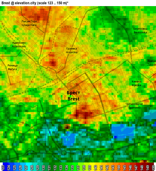
Below is the Elevation map of Brest, which displays elevation range with different colors. Scale of the first map is from 123 to 150 m (404 to 492 ft) with average elevation of 136.8 meters (=449 ft) [note 1]
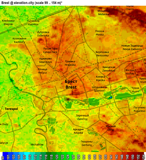
These maps also provides idea of topography and contour of this city, they are displayed at different zoom levels. More info about maps, scale and edge coordinates you can find below images.
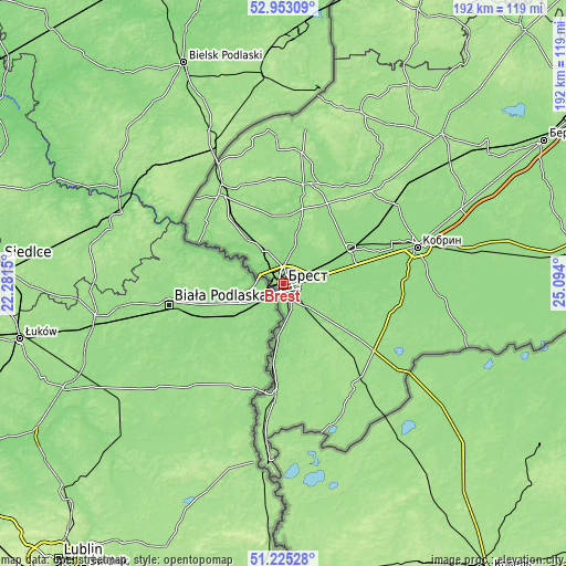
| \ | Map #1 | Map #2 | Topo.Map |
| Scale [m] | 123..150 m | 99..154 m | × |
| Scale [ft] | 404..492 ft | 325..505 ft | × |
| Average | 136.8 m = 449 ft | 135.1 m = 443 ft | × |
| Width | 6 km = 3.7 mi | 12.01 km = 7.5 mi | 192.1 km = 119.4 mi |
| Height | 6 km = 3.7 mi | 12.01 km = 7.5 mi | 192.1 km = 119.4 mi |
| ↑Max Latitude | 52.124538° | 52.15151° | 52.95309° |
| Latitude at center | 52.09755° | 52.09755° | 52.09755° |
| ↓Min Latitude | 52.070545° | 52.043524° | 51.22528° |
| ← Min Longitude | 23.643805° | 23.599859° | 22.2815° |
| Longitude center | 23.68775° | 23.68775° | 23.68775° |
| →Max Longitude | 23.731695° | 23.775641° | 25.094° |
Nearby cities:
Cities around Brest sort by population:
• Kobryn elevation 140 m
47.4 km,  74°
74°
• Pruzhany 161 m
73 km,  45°
45°
• Zhabinka 140 m
24.8 km,  63°
63°
• Malaryta 157 m
43.2 km,  142°
142°
• Kamyanyets 141 m
34.7 km,  13°
13°
• Vysokaye 151 m
37.3 km,  324°
324°
• Charnawchytsy 141 m
14 km, 14°
• Antopal’ 150 m
75.9 km,  81°
81°
• Znamenka 147 m
24.1 km,  185°
185°
• Kamyanyuki 146 m
51.8 km, 8°
• Damachava 150 m
39.1 km, 188°
• Horad Kobryn 139 m
48.1 km, 74°
Multilingual:
 En español:
Brest elevación 142 m.
 En France:
Brest élévation 142 m.
 Auf Deutsch:
Brest, Brest-Litowsk höhe über dem Meeresspiegel ist 142 m.

Sources and notes:
- [note 1] Map square and city borders are not equal. Map elevation data is calculated only from area inside that square.
- [src 1] Elevation data from geonames database provided with same terms of usage.
- [src 2] The elevation map of Brest is generated using elevation data from NASA's 3 arcsec (90m) resolution SRTM data.
- [src 3] Base (background) map © OpenStreetMap contributors tiles are generated by Geofabrik and OpenTopoMap.
Copyright & License:
This Brest Elevation Map is licensed under CC BY-SA. You may reuse any part from this page, if you give a proper credit by linking to this URL:
 More info on terms of use page.