Ivanava elevation
Ivanava (Brest), Belarus elevation is 148 meters and Ivanava elevation in feet is 486 ft above sea level [src 1]. Ivanava is a seat of a second-order administrative division (feature code) with elevation that is 19 meters (62 ft) smaller than average city elevation in Belarus.
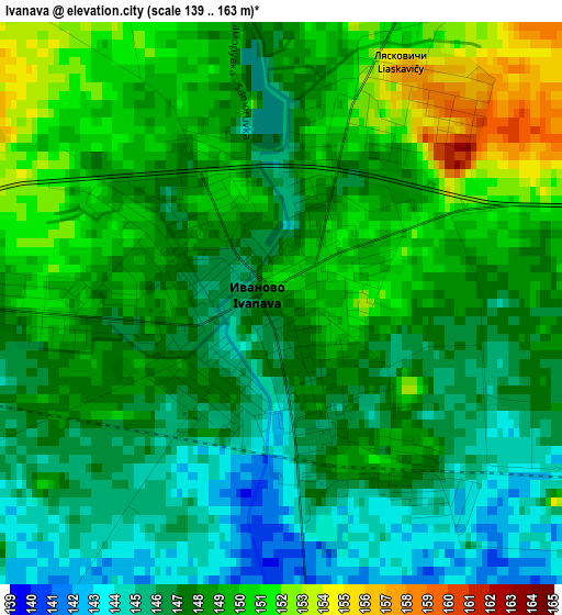
Below is the Elevation map of Ivanava, which displays elevation range with different colors. Scale of the first map is from 139 to 163 m (456 to 535 ft) with average elevation of 147.7 meters (=485 ft) [note 1]
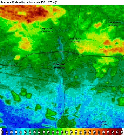
These maps also provides idea of topography and contour of this city, they are displayed at different zoom levels. More info about maps, scale and edge coordinates you can find below images.
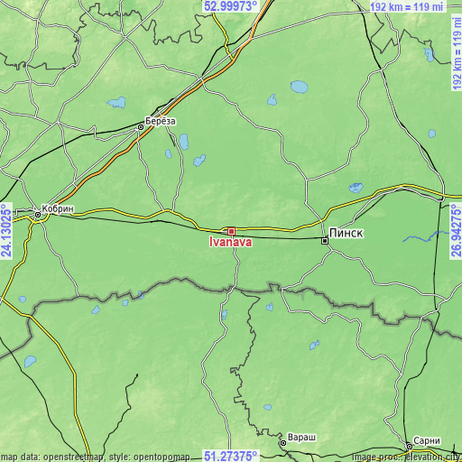
| \ | Map #1 | Map #2 | Topo.Map |
| Scale [m] | 139..163 m | 135..175 m | × |
| Scale [ft] | 456..535 ft | 443..574 ft | × |
| Average | 147.7 m = 485 ft | 148.7 m = 488 ft | × |
| Width | 6 km = 3.7 mi | 11.99 km = 7.5 mi | 191.9 km = 119.2 mi |
| Height | 6 km = 3.7 mi | 11.99 km = 7.5 mi | 191.9 km = 119.2 mi |
| ↑Max Latitude | 52.172059° | 52.199003° | 52.99973° |
| Latitude at center | 52.1451° | 52.1451° | 52.1451° |
| ↓Min Latitude | 52.118124° | 52.091132° | 51.27375° |
| ← Min Longitude | 25.492555° | 25.448609° | 24.13025° |
| Longitude center | 25.5365° | 25.5365° | 25.5365° |
| →Max Longitude | 25.580445° | 25.624391° | 26.94275° |
Nearby cities:
Cities around Ivanava sort by population:
• Pinsk elevation 139 m
38.2 km,  93°
93°
• Byaroza 150 m
57.3 km,  318°
318°
• Ivatsevichy 155 m
64.1 km,  348°
348°
• Drahichyn 151 m
26.1 km,  280°
280°
• Byelaazyorsk 148 m
43.8 km,  326°
326°
• Tsyelyakhany 152 m
46.3 km,  26°
26°
• Motal’ 140 m
19.4 km,  14°
14°
• Lahishyn 171 m
37.5 km,  54°
54°
• Antopal’ 150 m
51.6 km, 277°
• Nyakhachava 148 m
59.9 km,  337°
337°
• Asnyezhytsy 140 m
40.8 km,  83°
83°
• Horad Pinsk 138 m
36.7 km, 94°
Multilingual:
 En español:
Ivanava elevación 148 m.
 En France:
Ivanava élévation 148 m.


Sources and notes:
- [note 1] Map square and city borders are not equal. Map elevation data is calculated only from area inside that square.
- [src 1] Elevation data from geonames database provided with same terms of usage.
- [src 2] The elevation map of Ivanava is generated using elevation data from NASA's 3 arcsec (90m) resolution SRTM data.
- [src 3] Base (background) map © OpenStreetMap contributors tiles are generated by Geofabrik and OpenTopoMap.
Copyright & License:
This Ivanava Elevation Map is licensed under CC BY-SA. You may reuse any part from this page, if you give a proper credit by linking to this URL:
 More info on terms of use page.