Syanno elevation
Syanno (Vitebsk), Belarus elevation is 165 meters and Syanno elevation in feet is 541 ft above sea level [src 1]. Syanno is a populated place (feature code) with elevation that is 2 meters (7 ft) smaller than average city elevation in Belarus.
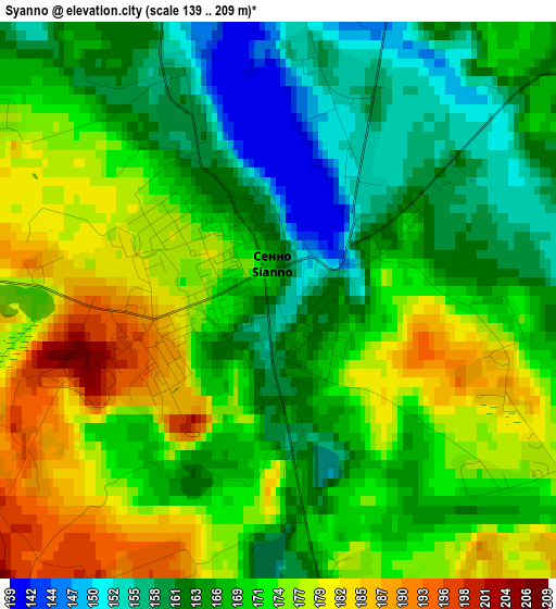
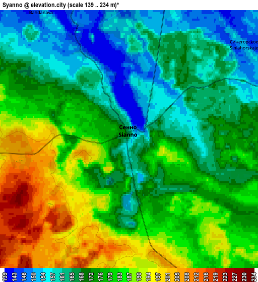
Below is the Elevation map of Syanno, which displays elevation range with different colors. Scale of the first map is from 139 to 209 m (456 to 686 ft) with average elevation of 169.6 meters (=556 ft) [note 1]
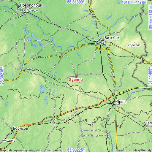
These maps also provides idea of topography and contour of this city, they are displayed at different zoom levels. More info about maps, scale and edge coordinates you can find below images.
| \ | Map #1 | Map #2 | Topo.Map |
| Scale [m] | 139..209 m | 139..234 m | × |
| Scale [ft] | 456..686 ft | 456..768 ft | × |
| Average | 169.6 m = 556 ft | 174.8 m = 573 ft | × |
| Width | 5.63 km = 3.5 mi | 11.26 km = 7 mi | 180.2 km = 112 mi |
| Height | 5.63 km = 3.5 mi | 11.26 km = 7 mi | 180.2 km = 112 mi |
| ↑Max Latitude | 54.836117° | 54.861418° | 55.61309° |
| Latitude at center | 54.8108° | 54.8108° | 54.8108° |
| ↓Min Latitude | 54.785467° | 54.760119° | 53.99225° |
| ← Min Longitude | 29.664655° | 29.620709° | 28.30235° |
| Longitude center | 29.7086° | 29.7086° | 29.7086° |
| →Max Longitude | 29.752545° | 29.796491° | 31.11485° |
Nearby cities:
Cities around Syanno sort by population:
• Vitebsk elevation 150 m
52.8 km,  36°
36°
• Orsha 159 m
56.7 km,  126°
126°
• Novolukoml’ 175 m
39.5 km,  245°
245°
• Baran’ 162 m
53.8 km, 133°
• Chashniki 136 m
35.5 km,  278°
278°
• Talachyn 199 m
44.7 km,  181°
181°
• Kokhanava 216 m
43.2 km,  154°
154°
• Konstantinovo 176 m
32.9 km,  239°
239°
• Balbasava 202 m
57.3 km,  139°
139°
• Kholopenichi 190 m
58.3 km, 236°
• Bobr 176 m
59.2 km,  208°
208°
• Horad Orsha 179 m
55.6 km, 126°
Multilingual:
 En español:
Syanno elevación 165 m.
 En France:
Syanno élévation 165 m.


Sources and notes:
- [note 1] Map square and city borders are not equal. Map elevation data is calculated only from area inside that square.
- [src 1] Elevation data from geonames database provided with same terms of usage.
- [src 2] The elevation map of Syanno is generated using elevation data from NASA's 3 arcsec (90m) resolution SRTM data.
- [src 3] Base (background) map © OpenStreetMap contributors tiles are generated by Geofabrik and OpenTopoMap.
Copyright & License:
This Syanno Elevation Map is licensed under CC BY-SA. You may reuse any part from this page, if you give a proper credit by linking to this URL:
 More info on terms of use page.