Zhirovichi elevation
Zhirovichi (Grodnenskaya), Belarus elevation is 149 meters and Zhirovichi elevation in feet is 489 ft above sea level [src 1]. Zhirovichi is a populated place (feature code) with elevation that is 18 meters (59 ft) smaller than average city elevation in Belarus.
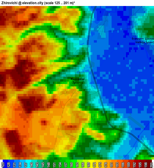
Below is the Elevation map of Zhirovichi, which displays elevation range with different colors. Scale of the first map is from 125 to 201 m (410 to 659 ft) with average elevation of 157.7 meters (=517 ft) [note 1]
These maps also provides idea of topography and contour of this city, they are displayed at different zoom levels. More info about maps, scale and edge coordinates you can find below images.
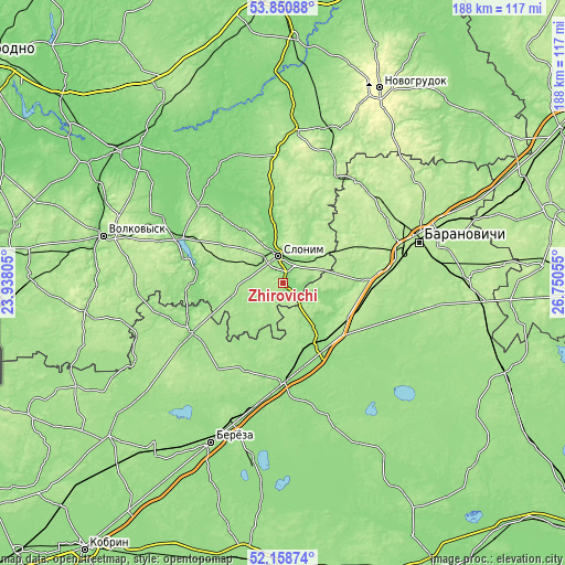
| \ | Map #1 | Topo.Map |
| Scale [m] | 125..201 m | × |
| Scale [ft] | 410..659 ft | × |
| Average | 157.7 m = 517 ft | × |
| Width | 5.88 km = 3.7 mi | 188.1 km = 116.9 mi |
| Height | 5.88 km = 3.7 mi | 188.1 km = 116.9 mi |
| ↑Max Latitude | 53.039531° | 53.85088° |
| Latitude at center | 53.0131° | 53.0131° |
| ↓Min Latitude | 52.986653° | 52.15874° |
| ← Min Longitude | 25.300355° | 23.93805° |
| Longitude center | 25.3443° | 25.3443° |
| →Max Longitude | 25.388245° | 26.75055° |
Nearby cities:
Cities around Zhirovichi sort by population:
• Baranovichi elevation 199 m
46.7 km,  73°
73°
• Slonim 149 m
8.4 km,  347°
347°
• Byaroza 150 m
58.9 km,  204°
204°
• Ivatsevichy 155 m
33.8 km,  180°
180°
• Lyakhavichy 181 m
61.7 km,  87°
87°
• Byelaazyorsk 148 m
61.1 km,  190°
190°
• Dyatlovo 163 m
50.2 km,  4°
4°
• Zel’va 138 m
38.5 km,  293°
293°
• Ruzhany 149 m
34.5 km,  241°
241°
• Kosava 164 m
31 km, 204°
• Haradzishcha 201 m
56.3 km,  52°
52°
• Nyakhachava 148 m
42.1 km, 193°
Multilingual:
 En español:
Zhirovichi elevación 149 m.
 En France:
Zhirovichi élévation 149 m.
 Auf Deutsch:
Zhirovichi höhe über dem Meeresspiegel ist 149 m.

Sources and notes:
- [note 1] Map square and city borders are not equal. Map elevation data is calculated only from area inside that square.
- [src 1] Elevation data from geonames database provided with same terms of usage.
- [src 2] The elevation map of Zhirovichi is generated using elevation data from NASA's 3 arcsec (90m) resolution SRTM data.
- [src 3] Base (background) map © OpenStreetMap contributors tiles are generated by Geofabrik and OpenTopoMap.
Copyright & License:
This Zhirovichi Elevation Map is licensed under CC BY-SA. You may reuse any part from this page, if you give a proper credit by linking to this URL:
 More info on terms of use page.