Lobatse elevation
Lobatse, Botswana elevation is 1191 meters and Lobatse elevation in feet is 3907 ft above sea level [src 1]. Lobatse is a populated place (feature code) with elevation that is 179 meters (587 ft) bigger than average city elevation in Botswana.
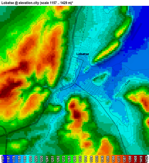
Below is the Elevation map of Lobatse, which displays elevation range with different colors. Scale of the first map is from 1157 to 1429 m (3796 to 4688 ft) with average elevation of 1256.5 meters (=4122 ft) [note 1]
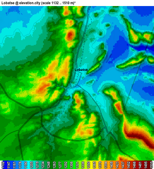
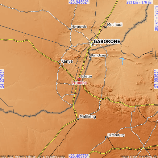
These maps also provides idea of topography and contour of this city, they are displayed at different zoom levels. More info about maps, scale and edge coordinates you can find below images.
| \ | Map #1 | Map #2 | Topo.Map |
| Scale [m] | 1157..1429 m | 1132..1510 m | × |
| Scale [ft] | 3796..4688 ft | 3714..4954 ft | × |
| Average | 1256.5 m = 4122 ft | 1253.3 m = 4112 ft | × |
| Width | 8.84 km = 5.5 mi | 17.68 km = 11 mi | 282.9 km = 175.8 mi |
| Height | 8.84 km = 5.5 mi | 17.68 km = 11 mi | 282.9 km = 175.8 mi |
| ↑Max Latitude | -25.184589° | -25.144814° | -23.94562° |
| Latitude at center | -25.22435° | -25.22435° | -25.22435° |
| ↓Min Latitude | -25.264098° | -25.303834° | -26.48978° |
| ← Min Longitude | 25.633335° | 25.589389° | 24.27103° |
| Longitude center | 25.67728° | 25.67728° | 25.67728° |
| →Max Longitude | 25.721225° | 25.765171° | 27.08353° |
Nearby cities:
Cities around Lobatse sort by population:
• Gaborone elevation 1011 m
67.5 km,  20°
20°
• Kanye 1406 m
45 km,  309°
309°
• Mogoditshane 1026 m
69.1 km, 15°
• Ramotswa 1039 m
43.8 km,  26°
26°
• Thamaga 1073 m
63.2 km,  347°
347°
• Mosopa 1136 m
56.5 km,  332°
332°
• Janeng 1311 m
24.9 km,  210°
210°
• Gabane 1090 m
62.9 km,  9°
9°
• Otse 1361 m
23.8 km, 13°
• Mmopone 1009 m
75.7 km, 15°
• Gaphatshwe 1010 m
74 km, 12°
• Nkoyaphiri 1053 m
67.6 km, 13°
Multilingual:
 En español:
Lobatse elevación 1191 m.
 En France:
Lobatse élévation 1191 m.
 Auf Deutsch:
Lobatse höhe über dem Meeresspiegel ist 1191 m.

Sources and notes:
- [note 1] Map square and city borders are not equal. Map elevation data is calculated only from area inside that square.
- [src 1] Elevation data from geonames database provided with same terms of usage.
- [src 2] The elevation map of Lobatse is generated using elevation data from NASA's 3 arcsec (90m) resolution SRTM data.
- [src 3] Base (background) map © OpenStreetMap contributors tiles are generated by Geofabrik and OpenTopoMap.
Copyright & License:
This Lobatse Elevation Map is licensed under CC BY-SA. You may reuse any part from this page, if you give a proper credit by linking to this URL:
 More info on terms of use page.