Chiprovtsi elevation
Chiprovtsi (Montana, Obshtina Chiprovtsi), Bulgaria elevation is 487 meters and Chiprovtsi elevation in feet is 1598 ft above sea level [src 1]. Chiprovtsi is a populated place (feature code) with elevation that is 168 meters (551 ft) bigger than average city elevation in Bulgaria.
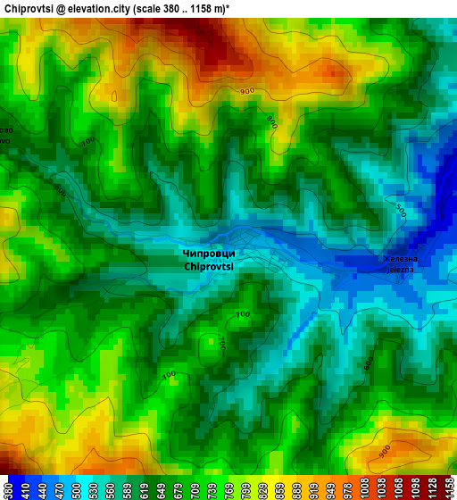
Below is the Elevation map of Chiprovtsi, which displays elevation range with different colors. Scale of the first map is from 380 to 1158 m (1247 to 3799 ft) with average elevation of 686.3 meters (=2252 ft) [note 1]
These maps also provides idea of topography and contour of this city, they are displayed at different zoom levels. More info about maps, scale and edge coordinates you can find below images.
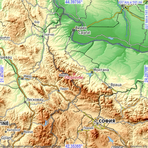
| \ | Map #1 | Topo.Map |
| Scale [m] | 380..1158 m | × |
| Scale [ft] | 1247..3799 ft | × |
| Average | 686.3 m = 2252 ft | × |
| Width | 7.1 km = 4.4 mi | 227.3 km = 141.2 mi |
| Height | 7.1 km = 4.4 mi | 227.3 km = 141.2 mi |
| ↑Max Latitude | 43.416099° | 44.39756° |
| Latitude at center | 43.38417° | 43.38417° |
| ↓Min Latitude | 43.352224° | 42.35355° |
| ← Min Longitude | 22.836885° | 21.47458° |
| Longitude center | 22.88083° | 22.88083° |
| →Max Longitude | 22.924775° | 24.28708° |
Nearby cities:
Cities around Chiprovtsi sort by population:
• Montana elevation 148 m
28 km,  83°
83°
• Berkovitsa 369 m
25.9 km,  129°
129°
• Varshets 408 m
39.1 km,  122°
122°
• Belogradchik 498 m
31.4 km,  329°
329°
• Godech 699 m
43 km,  161°
161°
• Medkovets 172 m
35.4 km,  41°
41°
• Boychinovtsi 105 m
38 km, 75°
• Brusartsi 99 m
34.2 km,  26°
26°
• Dimovo 128 m
41.6 km,  342°
342°
• Ruzhintsi 188 m
26.7 km,  351°
351°
• Chuprene 423 m
22.8 km,  310°
310°
• Drenovets 123 m
35 km,  12°
12°
Multilingual:
 En español:
Chiprovtsi elevación 487 m.
 En France:
Tchiprovtsi élévation 487 m.
 Auf Deutsch:
Tschiprowzi höhe über dem Meeresspiegel ist 487 m.

Sources and notes:
- [note 1] Map square and city borders are not equal. Map elevation data is calculated only from area inside that square.
- [src 1] Elevation data from geonames database provided with same terms of usage.
- [src 2] The elevation map of Chiprovtsi is generated using elevation data from NASA's 3 arcsec (90m) resolution SRTM data.
- [src 3] Base (background) map © OpenStreetMap contributors tiles are generated by Geofabrik and OpenTopoMap.
Copyright & License:
This Chiprovtsi Elevation Map is licensed under CC BY-SA. You may reuse any part from this page, if you give a proper credit by linking to this URL:
 More info on terms of use page.