Kula elevation
Kula (Vidin, Obshtina Kula), Bulgaria elevation is 281 meters and Kula elevation in feet is 922 ft above sea level [src 1]. Kula is a seat of a second-order administrative division (feature code) with elevation that is 38 meters (125 ft) smaller than average city elevation in Bulgaria.
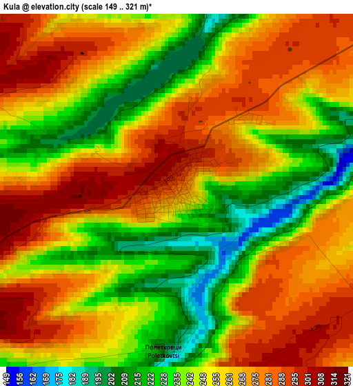
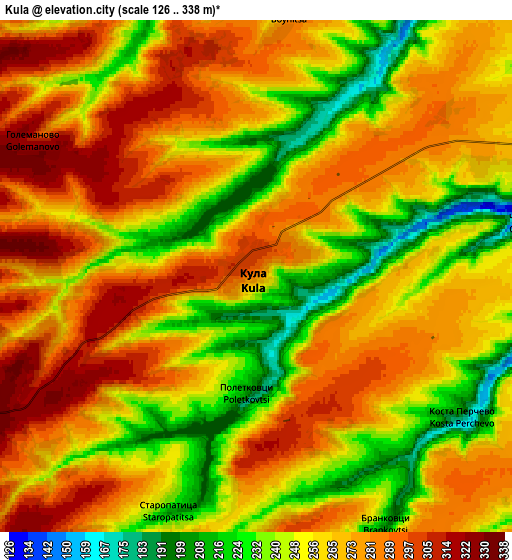
Below is the Elevation map of Kula, which displays elevation range with different colors. Scale of the first map is from 149 to 321 m (489 to 1053 ft) with average elevation of 255.3 meters (=838 ft) [note 1]
These maps also provides idea of topography and contour of this city, they are displayed at different zoom levels. More info about maps, scale and edge coordinates you can find below images.
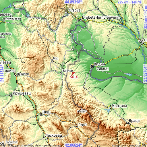
| \ | Map #1 | Map #2 | Topo.Map |
| Scale [m] | 149..321 m | 126..338 m | × |
| Scale [ft] | 489..1053 ft | 413..1109 ft | × |
| Average | 255.3 m = 838 ft | 263.6 m = 865 ft | × |
| Width | 7.04 km = 4.4 mi | 14.09 km = 8.8 mi | 225.4 km = 140.1 mi |
| Height | 7.04 km = 4.4 mi | 14.09 km = 8.8 mi | 225.4 km = 140.1 mi |
| ↑Max Latitude | 43.919993° | 43.951638° | 44.89318° |
| Latitude at center | 43.88833° | 43.88833° | 43.88833° |
| ↓Min Latitude | 43.856651° | 43.824954° | 42.86624° |
| ← Min Longitude | 22.477445° | 22.433499° | 21.11514° |
| Longitude center | 22.52139° | 22.52139° | 22.52139° |
| →Max Longitude | 22.565335° | 22.609281° | 23.92764° |
Nearby cities:
Cities around Kula sort by population:
• Vidin elevation 35 m
31.1 km,  68°
68°
• Belogradchik 498 m
31.8 km,  155°
155°
• Dunavtsi 41 m
24.3 km,  81°
81°
• Bregovo 54 m
30.8 km,  18°
18°
• Gramada 189 m
12 km,  118°
118°
• Novo Selo 40 m
37 km,  34°
34°
• Dimovo 128 m
23.2 km,  134°
134°
• Ruzhintsi 188 m
38.8 km,  139°
139°
• Boynitsa 285 m
7.6 km,  6°
6°
• Chuprene 423 m
42.8 km, 164°
• Makresh 176 m
17.6 km, 139°
• Drenovets 123 m
42.4 km, 121°
Multilingual:
 En español:
Kula elevación 281 m.
 En France:
Kula élévation 281 m.


Sources and notes:
- [note 1] Map square and city borders are not equal. Map elevation data is calculated only from area inside that square.
- [src 1] Elevation data from geonames database provided with same terms of usage.
- [src 2] The elevation map of Kula is generated using elevation data from NASA's 3 arcsec (90m) resolution SRTM data.
- [src 3] Base (background) map © OpenStreetMap contributors tiles are generated by Geofabrik and OpenTopoMap.
Copyright & License:
This Kula Elevation Map is licensed under CC BY-SA. You may reuse any part from this page, if you give a proper credit by linking to this URL:
 More info on terms of use page.