Tsarevo elevation
Tsarevo (Burgas, Obshtina Tsarevo), Bulgaria elevation is 36 meters and Tsarevo elevation in feet is 118 ft above sea level [src 1]. Tsarevo is a populated place (feature code) with elevation that is 283 meters (928 ft) smaller than average city elevation in Bulgaria.
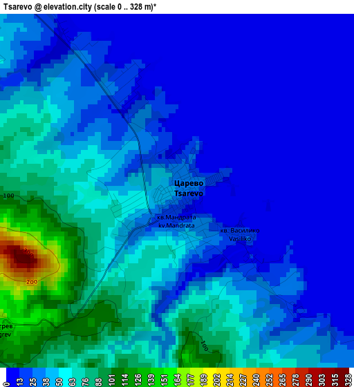
Below is the Elevation map of Tsarevo, which displays elevation range with different colors. Scale of the first map is from 0 to 328 m (0 to 1076 ft) with average elevation of 39.4 meters (=129 ft) [note 1]
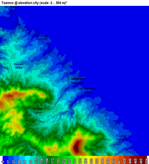
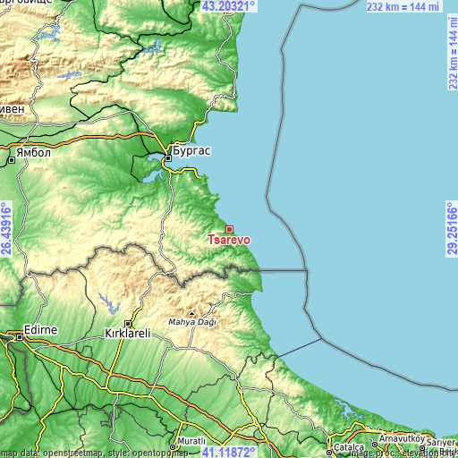
These maps also provides idea of topography and contour of this city, they are displayed at different zoom levels. More info about maps, scale and edge coordinates you can find below images.
| \ | Map #1 | Map #2 | Topo.Map |
| Scale [m] | 0..328 m | -2..504 m | × |
| Scale [ft] | 0..1076 ft | -7..1654 ft | × |
| Average | 39.4 m = 129 ft | 68.3 m = 224 ft | × |
| Width | 7.24 km = 4.5 mi | 14.49 km = 9 mi | 231.8 km = 144 mi |
| Height | 7.24 km = 4.5 mi | 14.49 km = 9 mi | 231.8 km = 144 mi |
| ↑Max Latitude | 42.202112° | 42.234658° | 43.20321° |
| Latitude at center | 42.16955° | 42.16955° | 42.16955° |
| ↓Min Latitude | 42.136971° | 42.104375° | 41.11872° |
| ← Min Longitude | 27.801465° | 27.757519° | 26.43916° |
| Longitude center | 27.84541° | 27.84541° | 27.84541° |
| →Max Longitude | 27.889355° | 27.933301° | 29.25166° |
Nearby cities:
Cities around Tsarevo sort by population:
• Burgas elevation 36 m
48.6 km,  320°
320°
• Pomorie 6 m
47.2 km,  337°
337°
• Nesebar 17 m
55.2 km,  350°
350°
• Sozopol 20 m
30.2 km, 335°
• Malko Tarnovo 346 m
33.9 km,  231°
231°
• Sarafovo 30 m
51 km,  328°
328°
• Primorsko 21 m
13.2 km, 326°
• Ravda 13 m
54.3 km, 345°
• Chernomorets 29 m
34.9 km, 330°
• Aheloy 25 m
55.8 km, 343°
• Kiten 26 m
9.2 km, 321°
• Ahtopol 24 m
11.1 km,  135°
135°
Multilingual:
 En español:
Tsarevo elevación 36 m.
 En France:
Tsarévo élévation 36 m.


Sources and notes:
- [note 1] Map square and city borders are not equal. Map elevation data is calculated only from area inside that square.
- [src 1] Elevation data from geonames database provided with same terms of usage.
- [src 2] The elevation map of Tsarevo is generated using elevation data from NASA's 3 arcsec (90m) resolution SRTM data.
- [src 3] Base (background) map © OpenStreetMap contributors tiles are generated by Geofabrik and OpenTopoMap.
Copyright & License:
This Tsarevo Elevation Map is licensed under CC BY-SA. You may reuse any part from this page, if you give a proper credit by linking to this URL:
 More info on terms of use page.