Smolyan elevation
Smolyan, Bulgaria elevation is 907 meters and Smolyan elevation in feet is 2976 ft above sea level [src 1]. Smolyan is a seat of a first-order administrative division (feature code) with elevation that is 588 meters (1929 ft) bigger than average city elevation in Bulgaria.
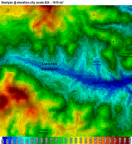
Below is the Elevation map of Smolyan, which displays elevation range with different colors. Scale of the first map is from 824 to 1619 m (2703 to 5312 ft) with average elevation of 1140.4 meters (=3741 ft) [note 1]
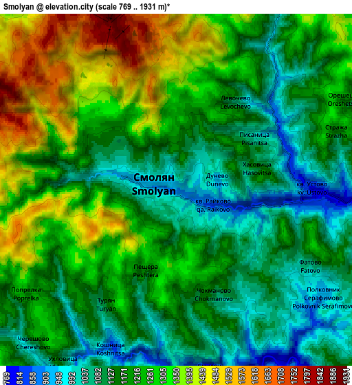
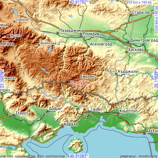
These maps also provides idea of topography and contour of this city, they are displayed at different zoom levels. More info about maps, scale and edge coordinates you can find below images.
| \ | Map #1 | Map #2 | Topo.Map |
| Scale [m] | 824..1619 m | 769..1931 m | × |
| Scale [ft] | 2703..5312 ft | 2523..6335 ft | × |
| Average | 1140.4 m = 3741 ft | 1212.8 m = 3979 ft | × |
| Width | 7.31 km = 4.5 mi | 14.62 km = 9.1 mi | 233.9 km = 145.3 mi |
| Height | 7.31 km = 4.5 mi | 14.62 km = 9.1 mi | 233.9 km = 145.3 mi |
| ↑Max Latitude | 41.607257° | 41.640107° | 42.61782° |
| Latitude at center | 41.57439° | 41.57439° | 41.57439° |
| ↓Min Latitude | 41.541506° | 41.508606° | 40.51383° |
| ← Min Longitude | 24.668095° | 24.624149° | 23.30579° |
| Longitude center | 24.71204° | 24.71204° | 24.71204° |
| →Max Longitude | 24.755985° | 24.799931° | 26.11829° |
Nearby cities:
Cities around Smolyan sort by population:
• Devin elevation 723 m
32 km,  305°
305°
• Zlatograd 435 m
38.6 km,  124°
124°
• Madan 682 m
20.7 km,  113°
113°
• Chepelare 1162 m
17.8 km,  352°
352°
• Nedelino 497 m
33.3 km, 113°
• Rudozem 693 m
15 km,  130°
130°
• Ardino 602 m
35.1 km,  88°
88°
• Laki 944 m
31.9 km,  15°
15°
• Borino 1149 m
36.9 km,  289°
289°
• Topolovo 471 m
43.4 km,  33°
33°
• Banite 728 m
25.8 km,  79°
79°
• Gyovren 1026 m
29.7 km, 289°
Multilingual:
 En español:
Smolyan elevación 907 m.
 En France:
Smolyan élévation 907 m.


Sources and notes:
- [note 1] Map square and city borders are not equal. Map elevation data is calculated only from area inside that square.
- [src 1] Elevation data from geonames database provided with same terms of usage.
- [src 2] The elevation map of Smolyan is generated using elevation data from NASA's 3 arcsec (90m) resolution SRTM data.
- [src 3] Base (background) map © OpenStreetMap contributors tiles are generated by Geofabrik and OpenTopoMap.
Copyright & License:
This Smolyan Elevation Map is licensed under CC BY-SA. You may reuse any part from this page, if you give a proper credit by linking to this URL:
 More info on terms of use page.