Suvorovo elevation
Suvorovo (Varna, Obshtina Suvorovo), Bulgaria elevation is 182 meters and Suvorovo elevation in feet is 597 ft above sea level [src 1]. Suvorovo is a populated place (feature code) with elevation that is 137 meters (449 ft) smaller than average city elevation in Bulgaria.
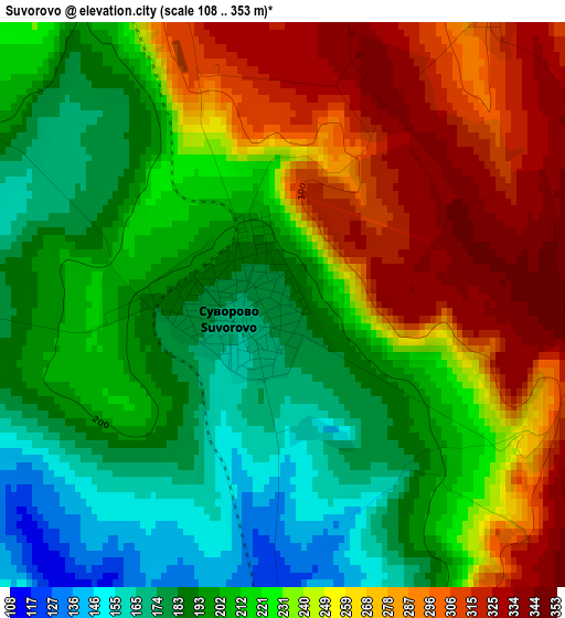
Below is the Elevation map of Suvorovo, which displays elevation range with different colors. Scale of the first map is from 108 to 353 m (354 to 1158 ft) with average elevation of 230.2 meters (=755 ft) [note 1]
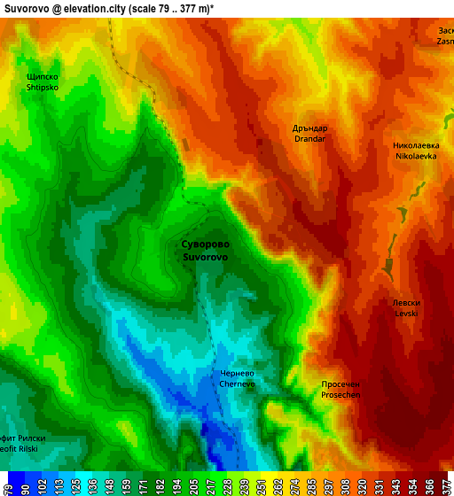
These maps also provides idea of topography and contour of this city, they are displayed at different zoom levels. More info about maps, scale and edge coordinates you can find below images.
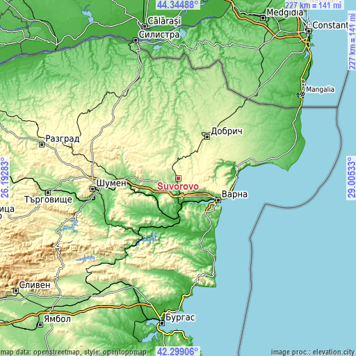
| \ | Map #1 | Map #2 | Topo.Map |
| Scale [m] | 108..353 m | 79..377 m | × |
| Scale [ft] | 354..1158 ft | 259..1237 ft | × |
| Average | 230.2 m = 755 ft | 249.8 m = 820 ft | × |
| Width | 7.11 km = 4.4 mi | 14.22 km = 8.8 mi | 227.5 km = 141.4 mi |
| Height | 7.11 km = 4.4 mi | 14.22 km = 8.8 mi | 227.5 km = 141.4 mi |
| ↑Max Latitude | 43.362538° | 43.394479° | 44.34488° |
| Latitude at center | 43.33058° | 43.33058° | 43.33058° |
| ↓Min Latitude | 43.298605° | 43.266614° | 42.29906° |
| ← Min Longitude | 27.555135° | 27.511189° | 26.19283° |
| Longitude center | 27.59908° | 27.59908° | 27.59908° |
| →Max Longitude | 27.643025° | 27.686971° | 29.00533° |
Nearby cities:
Cities around Suvorovo sort by population:
• Varna elevation 54 m
28.7 km,  116°
116°
• Dobrich 214 m
32.4 km,  35°
35°
• Asparuhovo 38 m
28.7 km,  125°
125°
• Provadia 173 m
21.2 km,  219°
219°
• Novi Pazar 135 m
32.3 km,  273°
273°
• Devnya 70 m
12.3 km,  191°
191°
• Beloslav 16 m
17.8 km,  151°
151°
• Aksakovo 118 m
19.8 km,  114°
114°
• Valchidol 265 m
8.7 km,  332°
332°
• Kaspichan 95 m
35 km, 267°
• Vetrino 211 m
13.5 km,  263°
263°
• Kiten 219 m
35.8 km, 219°
Multilingual:
 En español:
Suvorovo elevación 182 m.
 En France:
Suvorovo élévation 182 m.
 Auf Deutsch:
Suvorovo höhe über dem Meeresspiegel ist 182 m.

Sources and notes:
- [note 1] Map square and city borders are not equal. Map elevation data is calculated only from area inside that square.
- [src 1] Elevation data from geonames database provided with same terms of usage.
- [src 2] The elevation map of Suvorovo is generated using elevation data from NASA's 3 arcsec (90m) resolution SRTM data.
- [src 3] Base (background) map © OpenStreetMap contributors tiles are generated by Geofabrik and OpenTopoMap.
Copyright & License:
This Suvorovo Elevation Map is licensed under CC BY-SA. You may reuse any part from this page, if you give a proper credit by linking to this URL:
 More info on terms of use page.