Yakoruda elevation
Yakoruda (Blagoevgrad, Obshtina Yakoruda), Bulgaria elevation is 1028 meters and Yakoruda elevation in feet is 3373 ft above sea level [src 1]. Yakoruda is a populated place (feature code) with elevation that is 709 meters (2326 ft) bigger than average city elevation in Bulgaria.
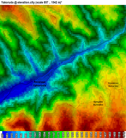
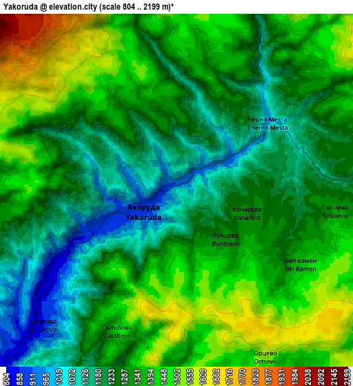
Below is the Elevation map of Yakoruda, which displays elevation range with different colors. Scale of the first map is from 857 to 1542 m (2812 to 5059 ft) with average elevation of 1162.8 meters (=3815 ft) [note 1]
These maps also provides idea of topography and contour of this city, they are displayed at different zoom levels. More info about maps, scale and edge coordinates you can find below images.
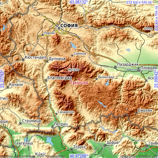
| \ | Map #1 | Map #2 | Topo.Map |
| Scale [m] | 857..1542 m | 804..2199 m | × |
| Scale [ft] | 2812..5059 ft | 2638..7215 ft | × |
| Average | 1162.8 m = 3815 ft | 1312.7 m = 4307 ft | × |
| Width | 7.26 km = 4.5 mi | 14.52 km = 9 mi | 232.3 km = 144.3 mi |
| Height | 7.26 km = 4.5 mi | 14.52 km = 9 mi | 232.3 km = 144.3 mi |
| ↑Max Latitude | 42.057916° | 42.090536° | 43.06132° |
| Latitude at center | 42.02528° | 42.02528° | 42.02528° |
| ↓Min Latitude | 41.992627° | 41.959957° | 40.97208° |
| ← Min Longitude | 23.640225° | 23.596279° | 22.27792° |
| Longitude center | 23.68417° | 23.68417° | 23.68417° |
| →Max Longitude | 23.728115° | 23.772061° | 25.09042° |
Nearby cities:
Cities around Yakoruda sort by population:
• Samokov elevation 945 m
36.3 km,  342°
342°
• Velingrad 750 m
25.4 km,  89°
89°
• Razlog 829 m
23.7 km,  229°
229°
• Bansko 929 m
26.3 km,  217°
217°
• Septemvri 235 m
42.2 km,  60°
60°
• Rakitovo 833 m
33.5 km,  96°
96°
• Dolna Banya 672 m
31.3 km,  12°
12°
• Sapareva Banya 855 m
44.8 km,  309°
309°
• Belovo 294 m
34.7 km,  53°
53°
• Batak 1037 m
45.1 km, 101°
• Belitsa 966 m
12 km, 230°
• Sarnitsa 1215 m
42.6 km,  138°
138°
Multilingual:
 En español:
Yakoruda elevación 1028 m.
 En France:
Yakoruda élévation 1028 m.
 Auf Deutsch:
Yakoruda höhe über dem Meeresspiegel ist 1028 m.

Sources and notes:
- [note 1] Map square and city borders are not equal. Map elevation data is calculated only from area inside that square.
- [src 1] Elevation data from geonames database provided with same terms of usage.
- [src 2] The elevation map of Yakoruda is generated using elevation data from NASA's 3 arcsec (90m) resolution SRTM data.
- [src 3] Base (background) map © OpenStreetMap contributors tiles are generated by Geofabrik and OpenTopoMap.
Copyright & License:
This Yakoruda Elevation Map is licensed under CC BY-SA. You may reuse any part from this page, if you give a proper credit by linking to this URL:
 More info on terms of use page.