Fada N'gourma elevation
Fada N'gourma (Est, Province du Gourma), Burkina Faso elevation is 298 meters and Fada N'gourma elevation in feet is 978 ft above sea level [src 1]. Fada N'gourma is a seat of a first-order administrative division (feature code) with elevation that is 6 meters (20 ft) smaller than average city elevation in Burkina Faso.
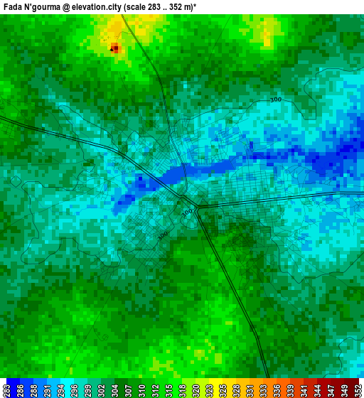
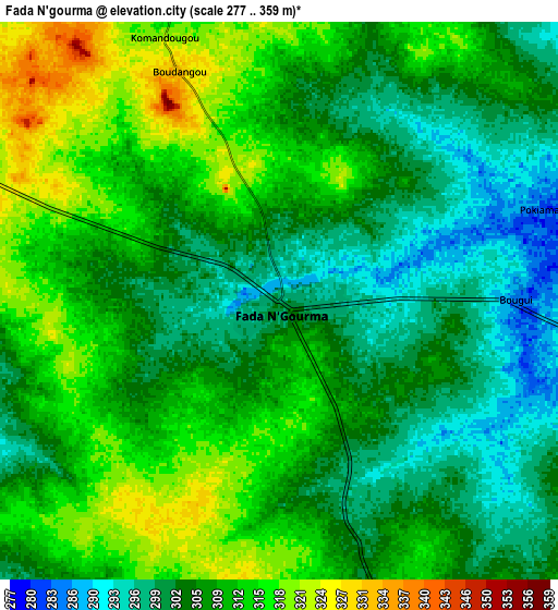
Below is the Elevation map of Fada N'gourma, which displays elevation range with different colors. Scale of the first map is from 283 to 352 m (928 to 1155 ft) with average elevation of 303.8 meters (=997 ft) [note 1]
These maps also provides idea of topography and contour of this city, they are displayed at different zoom levels. More info about maps, scale and edge coordinates you can find below images.
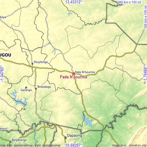
| \ | Map #1 | Map #2 | Topo.Map |
| Scale [m] | 283..352 m | 277..359 m | × |
| Scale [ft] | 928..1155 ft | 909..1178 ft | × |
| Average | 303.8 m = 997 ft | 307.4 m = 1009 ft | × |
| Width | 9.56 km = 5.9 mi | 19.11 km = 11.9 mi | 305.8 km = 190 mi |
| Height | 9.56 km = 5.9 mi | 19.11 km = 11.9 mi | 305.8 km = 190 mi |
| ↑Max Latitude | 12.104542° | 12.147507° | 13.43312° |
| Latitude at center | 12.06157° | 12.06157° | 12.06157° |
| ↓Min Latitude | 12.018591° | 11.975606° | 10.68297° |
| ← Min Longitude | 0.314485° | 0.270539° | -1.04782° |
| Longitude center | 0.35843° | 0.35843° | 0.35843° |
| →Max Longitude | 0.402375° | 0.446321° | 1.76468° |
Nearby cities:
Cities around Fada N'gourma sort by population:
• Tenkodogo elevation 304 m
85.2 km,  248°
248°
• Koupéla 306 m
78.2 km,  279°
279°
• Garango 304 m
103.1 km, 253°
• Zorgo 312 m
107.9 km, 281°
• Boulsa 313 m
121.6 km,  303°
303°
• Ouargaye 292 m
70.2 km,  207°
207°
• Bogandé 287 m
115.1 km,  331°
331°
• Pama 222 m
97.9 km,  157°
157°
• Gayéri 281 m
66.9 km,  12°
12°
• Sebba 252 m
154 km, 6°
• Mani 264 m
146.8 km,  335°
335°
• Bilanga 280 m
68.1 km,  322°
322°
Multilingual:
 En español:
Fada N'gourma elevación 298 m.
 En France:
Fada N'gourma élévation 298 m.
 Auf Deutsch:
Fada N'gourma höhe über dem Meeresspiegel ist 298 m.

Sources and notes:
- [note 1] Map square and city borders are not equal. Map elevation data is calculated only from area inside that square.
- [src 1] Elevation data from geonames database provided with same terms of usage.
- [src 2] The elevation map of Fada N'gourma is generated using elevation data from NASA's 3 arcsec (90m) resolution SRTM data.
- [src 3] Base (background) map © OpenStreetMap contributors tiles are generated by Geofabrik and OpenTopoMap.
Copyright & License:
This Fada N'gourma Elevation Map is licensed under CC BY-SA. You may reuse any part from this page, if you give a proper credit by linking to this URL:
 More info on terms of use page.