Haacht elevation
Haacht (Flanders, Provincie Vlaams-Brabant), Belgium elevation is 10 meters and Haacht elevation in feet is 33 ft above sea level [src 1]. Haacht is a populated place (feature code) with elevation that is 89 meters (292 ft) smaller than average city elevation in Belgium.
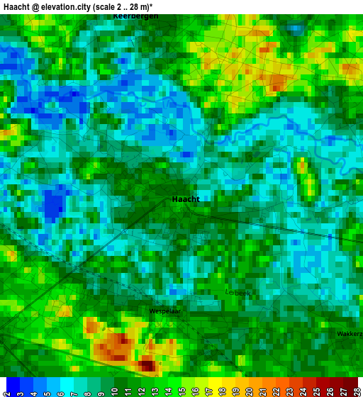
Below is the Elevation map of Haacht, which displays elevation range with different colors. Scale of the first map is from 2 to 28 m (7 to 92 ft) with average elevation of 9.9 meters (=32 ft) [note 1]
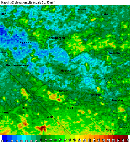
These maps also provides idea of topography and contour of this city, they are displayed at different zoom levels. More info about maps, scale and edge coordinates you can find below images.
| \ | Map #1 | Map #2 | Topo.Map |
| Scale [m] | 2..28 m | 0..33 m | × |
| Scale [ft] | 7..92 ft | 0..108 ft | × |
| Average | 9.9 m = 32 ft | 11 m = 36 ft | × |
| Width | 6.15 km = 3.8 mi | 12.31 km = 7.6 mi | 196.9 km = 122.3 mi |
| Height | 6.15 km = 3.8 mi | 12.31 km = 7.6 mi | 196.9 km = 122.3 mi |
| ↑Max Latitude | 51.005031° | 51.032675° | 51.85436° |
| Latitude at center | 50.97737° | 50.97737° | 50.97737° |
| ↓Min Latitude | 50.949693° | 50.921999° | 50.0835° |
| ← Min Longitude | 4.593825° | 4.549879° | 3.23152° |
| Longitude center | 4.63777° | 4.63777° | 4.63777° |
| →Max Longitude | 4.681715° | 4.725661° | 6.04402° |
Nearby cities:
Cities around Haacht sort by population:
• Leuven elevation 28 m
11.7 km,  157°
157°
• Herent 27 m
8 km, 163°
• Putte 22 m
8.5 km,  357°
357°
• Rotselaar 12 m
6.2 km,  116°
116°
• Bonheiden 7 m
8.1 km,  308°
308°
• Tremelo 10 m
5.2 km,  71°
71°
• Keerbergen 10 m
2.9 km, 355°
• Boortmeerbeek 10 m
4.4 km,  272°
272°
• Kampenhout 14 m
7.2 km,  237°
237°
• Steenokkerzeel 23 m
11.1 km,  233°
233°
• Begijnendijk 13 m
11.2 km, 65°
• Holsbeek 21 m
10.5 km,  126°
126°
Multilingual:
 En español:
Haacht elevación 10 m.
 En France:
Haacht élévation 10 m.


Sources and notes:
- [note 1] Map square and city borders are not equal. Map elevation data is calculated only from area inside that square.
- [src 1] Elevation data from geonames database provided with same terms of usage.
- [src 2] The elevation map of Haacht is generated using elevation data from NASA's 3 arcsec (90m) resolution SRTM data.
- [src 3] Base (background) map © OpenStreetMap contributors tiles are generated by Geofabrik and OpenTopoMap.
Copyright & License:
This Haacht Elevation Map is licensed under CC BY-SA. You may reuse any part from this page, if you give a proper credit by linking to this URL:
 More info on terms of use page.