Léglise elevation
Léglise (Wallonia, Province du Luxembourg), Belgium elevation is 395 meters and Léglise elevation in feet is 1296 ft above sea level [src 1]. Léglise is a populated place (feature code) with elevation that is 296 meters (971 ft) bigger than average city elevation in Belgium.
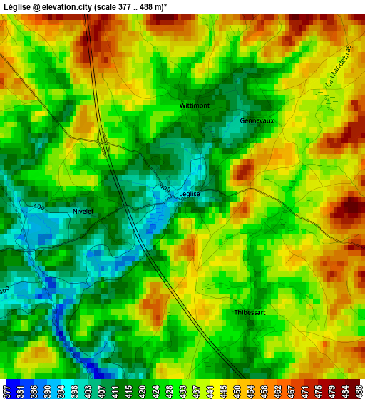
Below is the Elevation map of Léglise, which displays elevation range with different colors. Scale of the first map is from 377 to 488 m (1237 to 1601 ft) with average elevation of 431.5 meters (=1416 ft) [note 1]
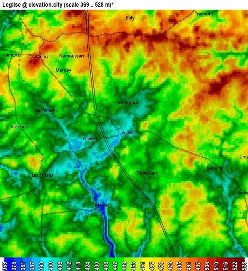
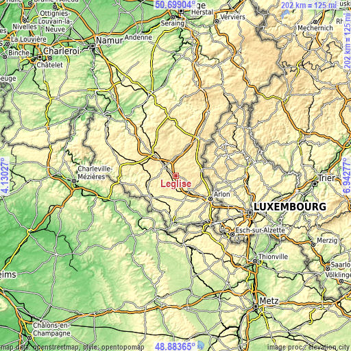
These maps also provides idea of topography and contour of this city, they are displayed at different zoom levels. More info about maps, scale and edge coordinates you can find below images.
| \ | Map #1 | Map #2 | Topo.Map |
| Scale [m] | 377..488 m | 369..528 m | × |
| Scale [ft] | 1237..1601 ft | 1211..1732 ft | × |
| Average | 431.5 m = 1416 ft | 447.1 m = 1467 ft | × |
| Width | 6.31 km = 3.9 mi | 12.62 km = 7.8 mi | 201.9 km = 125.5 mi |
| Height | 6.31 km = 3.9 mi | 12.62 km = 7.8 mi | 201.8 km = 125.4 mi |
| ↑Max Latitude | 49.828207° | 49.856547° | 50.69904° |
| Latitude at center | 49.79985° | 49.79985° | 49.79985° |
| ↓Min Latitude | 49.771477° | 49.743087° | 48.88365° |
| ← Min Longitude | 5.492575° | 5.448629° | 4.13027° |
| Longitude center | 5.53652° | 5.53652° | 5.53652° |
| →Max Longitude | 5.580465° | 5.624411° | 6.94277° |
Nearby cities:
Cities around Léglise sort by population:
• Bertrix elevation 438 m
21.1 km,  287°
287°
• Habay-la-Vieille 370 m
10.4 km,  144°
144°
• Neufchâteau 424 m
8.6 km,  302°
302°
• Florenville 342 m
19.9 km,  235°
235°
• Étalle 334 m
14.7 km,  161°
161°
• Chiny 375 m
15.6 km, 244°
• Vaux-sur-Sûre 433 m
12.7 km,  13°
13°
• Attert 298 m
18.8 km,  107°
107°
• Tintigny 336 m
13.1 km,  187°
187°
• Fauvillers 463 m
10.8 km,  58°
58°
• Herbeumont 310 m
21.7 km,  264°
264°
• Martelange 364 m
14.8 km,  76°
76°
Multilingual:
 En español:
Léglise elevación 395 m.
 En France:
Léglise élévation 395 m.


Sources and notes:
- [note 1] Map square and city borders are not equal. Map elevation data is calculated only from area inside that square.
- [src 1] Elevation data from geonames database provided with same terms of usage.
- [src 2] The elevation map of Léglise is generated using elevation data from NASA's 3 arcsec (90m) resolution SRTM data.
- [src 3] Base (background) map © OpenStreetMap contributors tiles are generated by Geofabrik and OpenTopoMap.
Copyright & License:
This Léglise Elevation Map is licensed under CC BY-SA. You may reuse any part from this page, if you give a proper credit by linking to this URL:
 More info on terms of use page.