Nassogne elevation
Nassogne (Wallonia, Province du Luxembourg), Belgium elevation is 385 meters and Nassogne elevation in feet is 1263 ft above sea level [src 1]. Nassogne is a populated place (feature code) with elevation that is 286 meters (938 ft) bigger than average city elevation in Belgium.
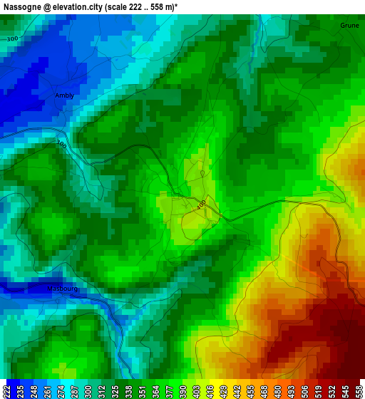
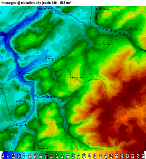
Below is the Elevation map of Nassogne, which displays elevation range with different colors. Scale of the first map is from 222 to 558 m (728 to 1831 ft) with average elevation of 352.3 meters (=1156 ft) [note 1]
These maps also provides idea of topography and contour of this city, they are displayed at different zoom levels. More info about maps, scale and edge coordinates you can find below images.
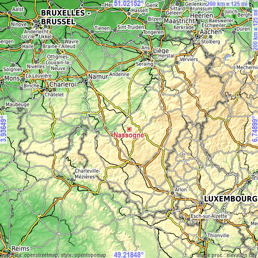
| \ | Map #1 | Map #2 | Topo.Map |
| Scale [m] | 222..558 m | 180..566 m | × |
| Scale [ft] | 728..1831 ft | 591..1857 ft | × |
| Average | 352.3 m = 1156 ft | 353.8 m = 1161 ft | × |
| Width | 6.26 km = 3.9 mi | 12.53 km = 7.8 mi | 200.5 km = 124.6 mi |
| Height | 6.26 km = 3.9 mi | 12.53 km = 7.8 mi | 200.5 km = 124.6 mi |
| ↑Max Latitude | 50.156654° | 50.184801° | 51.02152° |
| Latitude at center | 50.12849° | 50.12849° | 50.12849° |
| ↓Min Latitude | 50.10031° | 50.072113° | 49.21848° |
| ← Min Longitude | 5.298795° | 5.254849° | 3.93649° |
| Longitude center | 5.34274° | 5.34274° | 5.34274° |
| →Max Longitude | 5.386685° | 5.430631° | 6.74899° |
Nearby cities:
Cities around Nassogne sort by population:
• Marche-en-Famenne elevation 214 m
10.9 km,  0°
0°
• Rochefort 170 m
9.5 km,  294°
294°
• Saint-Hubert 432 m
11.5 km,  168°
168°
• Hotton 177 m
17.1 km,  25°
25°
• Libin 401 m
17.5 km,  200°
200°
• La Roche-en-Ardenne 225 m
17.7 km,  69°
69°
• Wellin 250 m
17.1 km,  252°
252°
• Tenneville 380 m
13.8 km,  105°
105°
• Tellin 263 m
10.5 km,  239°
239°
• Rendeux 194 m
16.4 km,  44°
44°
• Sainte-Ode 428 m
17.7 km,  134°
134°
• Daverdisse 299 m
20 km,  233°
233°
Multilingual:
 En español:
Nassogne elevación 385 m.
 En France:
Nassogne élévation 385 m.
 Auf Deutsch:
Nassogne höhe über dem Meeresspiegel ist 385 m.

Sources and notes:
- [note 1] Map square and city borders are not equal. Map elevation data is calculated only from area inside that square.
- [src 1] Elevation data from geonames database provided with same terms of usage.
- [src 2] The elevation map of Nassogne is generated using elevation data from NASA's 3 arcsec (90m) resolution SRTM data.
- [src 3] Base (background) map © OpenStreetMap contributors tiles are generated by Geofabrik and OpenTopoMap.
Copyright & License:
This Nassogne Elevation Map is licensed under CC BY-SA. You may reuse any part from this page, if you give a proper credit by linking to this URL:
 More info on terms of use page.