Sarishābāri elevation
Sarishābāri (Mymensingh Division, Jamalpur), Bangladesh elevation is 22 meters and Sarishābāri elevation in feet is 72 ft above sea level [src 1]. Sarishābāri is a populated place (feature code) with elevation that is 4 meters (13 ft) bigger than average city elevation in Bangladesh.
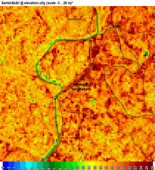
Below is the Elevation map of Sarishābāri, which displays elevation range with different colors. Scale of the first map is from -3 to 26 m (-10 to 85 ft) with average elevation of 18.4 meters (=60 ft) [note 1]
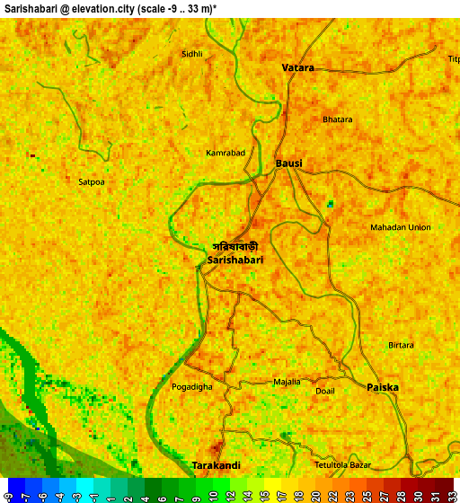
These maps also provides idea of topography and contour of this city, they are displayed at different zoom levels. More info about maps, scale and edge coordinates you can find below images.
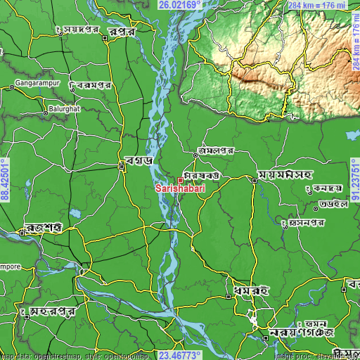
| \ | Map #1 | Map #2 | Topo.Map |
| Scale [m] | -3..26 m | -9..33 m | × |
| Scale [ft] | -10..85 ft | -30..108 ft | × |
| Average | 18.4 m = 60 ft | 17.9 m = 59 ft | × |
| Width | 8.87 km = 5.5 mi | 17.75 km = 11 mi | 284 km = 176.5 mi |
| Height | 8.87 km = 5.5 mi | 17.75 km = 11 mi | 284 km = 176.5 mi |
| ↑Max Latitude | 24.791172° | 24.831061° | 26.02169° |
| Latitude at center | 24.75127° | 24.75127° | 24.75127° |
| ↓Min Latitude | 24.711355° | 24.671428° | 23.46773° |
| ← Min Longitude | 89.787315° | 89.743369° | 88.42501° |
| Longitude center | 89.83126° | 89.83126° | 89.83126° |
| →Max Longitude | 89.875205° | 89.919151° | 91.23751° |
Nearby cities:
Cities around Sarishābāri sort by population:
• Shibganj elevation 26 m
58.4 km,  298°
298°
• Mymensingh 19 m
58.1 km,  89°
89°
• Bogra 26 m
47.8 km,  283°
283°
• Tāngāil 17 m
56.4 km,  171°
171°
• Jamālpur 23 m
22.1 km,  32°
32°
• Sirajganj 19 m
34.9 km,  200°
200°
• Sherpur 25 m
35.2 km, 32°
• Shāhzādpur 16 m
68.1 km, 200°
• Sakhipur 25 m
58.9 km,  144°
144°
• Muktāgācha 22 m
43 km, 87°
• Mahasthangarh 24 m
54.5 km, 295°
• Gaibandha 28 m
70.5 km,  335°
335°
Multilingual:
 En español:
Sarishābāri elevación 22 m.
 En France:
Sarishābāri élévation 22 m.
 Auf Deutsch:
Sarishābāri höhe über dem Meeresspiegel ist 22 m.

Sources and notes:
- [note 1] Map square and city borders are not equal. Map elevation data is calculated only from area inside that square.
- [src 1] Elevation data from geonames database provided with same terms of usage.
- [src 2] The elevation map of Sarishābāri is generated using elevation data from NASA's 3 arcsec (90m) resolution SRTM data.
- [src 3] Base (background) map © OpenStreetMap contributors tiles are generated by Geofabrik and OpenTopoMap.
Copyright & License:
This Sarishābāri Elevation Map is licensed under CC BY-SA. You may reuse any part from this page, if you give a proper credit by linking to this URL:
 More info on terms of use page.