Bridgetown elevation
Bridgetown (Saint Michael), Barbados elevation is 10 meters and Bridgetown elevation in feet is 33 ft above sea level [src 1]. Bridgetown is a capital of a political entity (feature code) with elevation that is 64 meters (210 ft) smaller than average city elevation in Barbados.
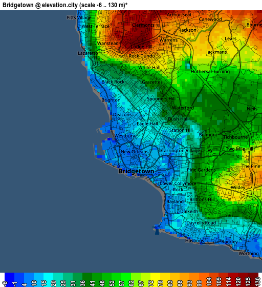
Below is the Elevation map of Bridgetown, which displays elevation range with different colors. Scale of the first map is from -6 to 130 m (-20 to 427 ft) with average elevation of 49.2 meters (=161 ft) [note 1]
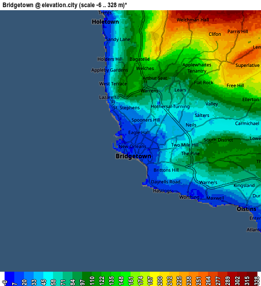
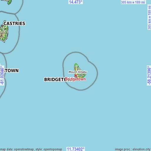
These maps also provides idea of topography and contour of this city, they are displayed at different zoom levels. More info about maps, scale and edge coordinates you can find below images.
| \ | Map #1 | Map #2 | Topo.Map |
| Scale [m] | -6..130 m | -6..328 m | × |
| Scale [ft] | -20..427 ft | -20..1076 ft | × |
| Average | 49.2 m = 161 ft | 108.9 m = 357 ft | × |
| Width | 9.52 km = 5.9 mi | 19.04 km = 11.8 mi | 304.5 km = 189.2 mi |
| Height | 9.52 km = 5.9 mi | 19.04 km = 11.8 mi | 304.6 km = 189.3 mi |
| ↑Max Latitude | 13.150117° | 13.192906° | 14.473° |
| Latitude at center | 13.10732° | 13.10732° | 13.10732° |
| ↓Min Latitude | 13.064516° | 13.021704° | 11.73402° |
| ← Min Longitude | -59.664155° | -59.708101° | -61.02646° |
| Longitude center | -59.62021° | -59.62021° | -59.62021° |
| →Max Longitude | -59.576265° | -59.532319° | -58.21396° |
Nearby cities:
Cities around Bridgetown sort by population:
• Speightstown elevation 9 m
16.2 km,  350°
350°
• Oistins 37 m
9 km,  117°
117°
• Bathsheba 69 m
15.4 km,  41°
41°
• Holetown -1 m
9 km, 347°
• Crane 24 m
18.6 km,  90°
90°
• Greenland 32 m
17.4 km,  15°
15°
• Checker Hall 52 m
19.8 km, 353°
• Four Cross Roads 220 m
12.7 km,  56°
56°
• Welchman Hall 291 m
10 km,  28°
28°
Multilingual:
 En español:
Bridgetown elevación 10 m.
 En France:
Bridgetown élévation 10 m.
 Auf Deutsch:
Bridgetown höhe über dem Meeresspiegel ist 10 m.

Sources and notes:
- [note 1] Map square and city borders are not equal. Map elevation data is calculated only from area inside that square.
- [src 1] Elevation data from geonames database provided with same terms of usage.
- [src 2] The elevation map of Bridgetown is generated using elevation data from NASA's 3 arcsec (90m) resolution SRTM data.
- [src 3] Base (background) map © OpenStreetMap contributors tiles are generated by Geofabrik and OpenTopoMap.
Copyright & License:
This Bridgetown Elevation Map is licensed under CC BY-SA. You may reuse any part from this page, if you give a proper credit by linking to this URL:
 More info on terms of use page.