Barda elevation
Barda (Bǝrdǝ), Azerbaijan elevation is 77 meters and Barda elevation in feet is 253 ft above sea level [src 1]. Barda is a seat of a first-order administrative division (feature code) with elevation that is 283 meters (928 ft) smaller than average city elevation in Azerbaijan.
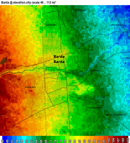
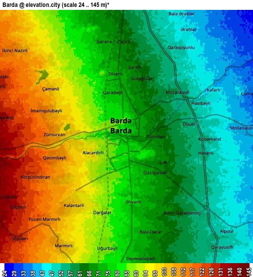
Below is the Elevation map of Barda, which displays elevation range with different colors. Scale of the first map is from 46 to 112 m (151 to 367 ft) with average elevation of 77.4 meters (=254 ft) [note 1]
These maps also provides idea of topography and contour of this city, they are displayed at different zoom levels. More info about maps, scale and edge coordinates you can find below images.
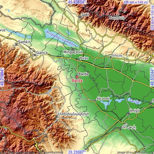
| \ | Map #1 | Map #2 | Topo.Map |
| Scale [m] | 46..112 m | 24..145 m | × |
| Scale [ft] | 151..367 ft | 79..476 ft | × |
| Average | 77.4 m = 254 ft | 77.3 m = 254 ft | × |
| Width | 7.44 km = 4.6 mi | 14.89 km = 9.3 mi | 238.2 km = 148 mi |
| Height | 7.44 km = 4.6 mi | 14.89 km = 9.3 mi | 238.2 km = 148 mi |
| ↑Max Latitude | 40.40924° | 40.442693° | 41.43854° |
| Latitude at center | 40.37577° | 40.37577° | 40.37577° |
| ↓Min Latitude | 40.342284° | 40.308781° | 39.29597° |
| ← Min Longitude | 47.082245° | 47.038299° | 45.71994° |
| Longitude center | 47.12619° | 47.12619° | 47.12619° |
| →Max Longitude | 47.170135° | 47.214081° | 48.53244° |
Nearby cities:
Cities around Barda sort by population:
• Yevlakh elevation 17 m
27 km,  4°
4°
• Mingelchaur 26 m
43.5 km,  352°
352°
• Agdzhabedy 15 m
45.9 km,  141°
141°
• Ağdaş 50 m
42.1 km,  44°
44°
• Terter 254 m
16.9 km,  257°
257°
• Martakert 438 m
31.7 km,  234°
234°
• Goranboy 156 m
38.6 km,  312°
312°
• Naftalan 251 m
29.8 km,  299°
299°
• Aran 53 m
30.5 km,  335°
335°
• Qızılhacılı 122 m
31.9 km, 314°
• Qaramanlı 103 m
16.3 km,  316°
316°
• Samuxlu 34 m
15.1 km,  14°
14°
Multilingual:
 En español:
Bərdə elevación 77 m.
 En France:
Barda élévation 77 m.


Sources and notes:
- [note 1] Map square and city borders are not equal. Map elevation data is calculated only from area inside that square.
- [src 1] Elevation data from geonames database provided with same terms of usage.
- [src 2] The elevation map of Barda is generated using elevation data from NASA's 3 arcsec (90m) resolution SRTM data.
- [src 3] Base (background) map © OpenStreetMap contributors tiles are generated by Geofabrik and OpenTopoMap.
Copyright & License:
This Barda Elevation Map is licensed under CC BY-SA. You may reuse any part from this page, if you give a proper credit by linking to this URL:
 More info on terms of use page.