Çinarlı elevation
Çinarlı (Qǝx), Azerbaijan elevation is 795 meters and Çinarlı elevation in feet is 2608 ft above sea level [src 1]. Çinarlı is a populated place (feature code) with elevation that is 435 meters (1427 ft) bigger than average city elevation in Azerbaijan.
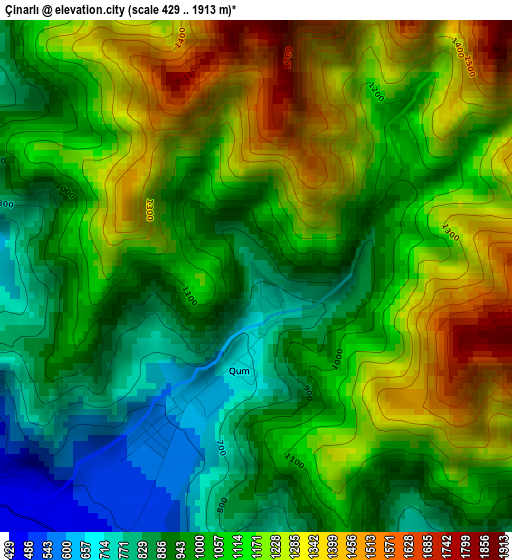
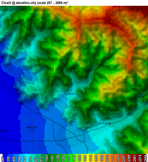
Below is the Elevation map of Çinarlı, which displays elevation range with different colors. Scale of the first map is from 429 to 1913 m (1407 to 6276 ft) with average elevation of 1082.7 meters (=3552 ft) [note 1]
These maps also provides idea of topography and contour of this city, they are displayed at different zoom levels. More info about maps, scale and edge coordinates you can find below images.
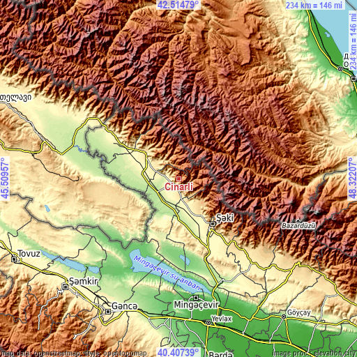
| \ | Map #1 | Map #2 | Topo.Map |
| Scale [m] | 429..1913 m | 267..2666 m | × |
| Scale [ft] | 1407..6276 ft | 876..8747 ft | × |
| Average | 1082.7 m = 3552 ft | 1084.7 m = 3559 ft | × |
| Width | 7.32 km = 4.5 mi | 14.65 km = 9.1 mi | 234.3 km = 145.6 mi |
| Height | 7.32 km = 4.5 mi | 14.65 km = 9.1 mi | 234.3 km = 145.6 mi |
| ↑Max Latitude | 41.50257° | 41.535474° | 42.51479° |
| Latitude at center | 41.46965° | 41.46965° | 41.46965° |
| ↓Min Latitude | 41.436713° | 41.40376° | 40.40739° |
| ← Min Longitude | 46.871875° | 46.827929° | 45.50957° |
| Longitude center | 46.91582° | 46.91582° | 46.91582° |
| →Max Longitude | 46.959765° | 47.003711° | 48.32207° |
Nearby cities:
Cities around Çinarlı sort by population:
• Sheki elevation 549 m
37.5 km,  145°
145°
• Zaqatala 503 m
28.9 km,  308°
308°
• Qax 590 m
5.7 km,  176°
176°
• Belokany 372 m
51.2 km,  303°
303°
• Aliabad 262 m
23.5 km,  273°
273°
• Qaxbaş 758 m
5.8 km,  135°
135°
• Qax İngiloy 656 m
5.4 km,  159°
159°
• Mamrux 519 m
14.8 km, 303°
• Faldarlı 209 m
33.3 km, 269°
• Baş Göynük 858 m
23 km,  134°
134°
• Qandax 219 m
31.2 km, 271°
• Qabaqçöl 267 m
62.2 km, 300°
Multilingual:
 En español:
Çinarlı elevación 795 m.
 En France:
Çinarlı élévation 795 m.


Sources and notes:
- [note 1] Map square and city borders are not equal. Map elevation data is calculated only from area inside that square.
- [src 1] Elevation data from geonames database provided with same terms of usage.
- [src 2] The elevation map of Çinarlı is generated using elevation data from NASA's 3 arcsec (90m) resolution SRTM data.
- [src 3] Base (background) map © OpenStreetMap contributors tiles are generated by Geofabrik and OpenTopoMap.
Copyright & License:
This Çinarlı Elevation Map is licensed under CC BY-SA. You may reuse any part from this page, if you give a proper credit by linking to this URL:
 More info on terms of use page.