Qusar elevation
Qusar, Azerbaijan elevation is 681 meters and Qusar elevation in feet is 2234 ft above sea level [src 1]. Qusar is a seat of a first-order administrative division (feature code) with elevation that is 321 meters (1053 ft) bigger than average city elevation in Azerbaijan.
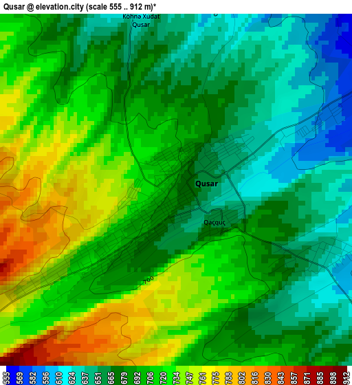
Below is the Elevation map of Qusar, which displays elevation range with different colors. Scale of the first map is from 555 to 912 m (1821 to 2992 ft) with average elevation of 693.9 meters (=2277 ft) [note 1]
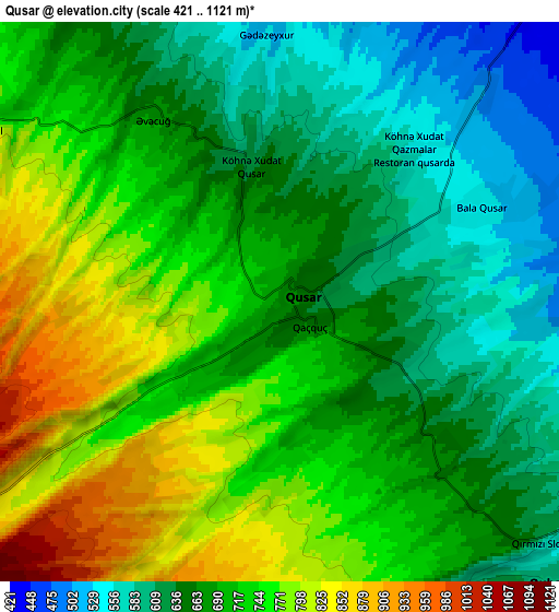
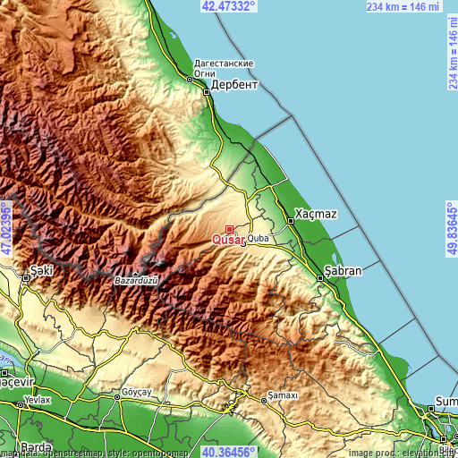
These maps also provides idea of topography and contour of this city, they are displayed at different zoom levels. More info about maps, scale and edge coordinates you can find below images.
| \ | Map #1 | Map #2 | Topo.Map |
| Scale [m] | 555..912 m | 421..1121 m | × |
| Scale [ft] | 1821..2992 ft | 1381..3678 ft | × |
| Average | 693.9 m = 2277 ft | 698.2 m = 2291 ft | × |
| Width | 7.33 km = 4.6 mi | 14.65 km = 9.1 mi | 234.5 km = 145.7 mi |
| Height | 7.33 km = 4.6 mi | 14.65 km = 9.1 mi | 234.5 km = 145.7 mi |
| ↑Max Latitude | 41.460442° | 41.493366° | 42.47332° |
| Latitude at center | 41.4275° | 41.4275° | 41.4275° |
| ↓Min Latitude | 41.394542° | 41.361567° | 40.36456° |
| ← Min Longitude | 48.386255° | 48.342309° | 47.02395° |
| Longitude center | 48.4302° | 48.4302° | 48.4302° |
| →Max Longitude | 48.474145° | 48.518091° | 49.83645° |
Nearby cities:
Cities around Qusar sort by population:
• Xaçmaz elevation 47 m
31.6 km,  82°
82°
• Divichibazar 44 m
52.9 km,  118°
118°
• Quba 600 m
10.1 km,  136°
136°
• Xudat 45 m
30.8 km,  42°
42°
• İsmayıllı 579 m
75.2 km,  198°
198°
• Qutqashen 795 m
69.4 km,  224°
224°
• Samur 307 m
23.3 km,  0°
0°
• Hacıhüseynli 258 m
18.5 km, 80°
• Basqal 1081 m
74.8 km,  182°
182°
• Gilgilçay 29 m
63.8 km, 120°
• Altıağac 1155 m
76.2 km,  146°
146°
• Kyzyl-Burun 13 m
69.2 km, 124°
Multilingual:
 En español:
Qusar elevación 681 m.
 En France:
Qusar élévation 681 m.


Sources and notes:
- [note 1] Map square and city borders are not equal. Map elevation data is calculated only from area inside that square.
- [src 1] Elevation data from geonames database provided with same terms of usage.
- [src 2] The elevation map of Qusar is generated using elevation data from NASA's 3 arcsec (90m) resolution SRTM data.
- [src 3] Base (background) map © OpenStreetMap contributors tiles are generated by Geofabrik and OpenTopoMap.
Copyright & License:
This Qusar Elevation Map is licensed under CC BY-SA. You may reuse any part from this page, if you give a proper credit by linking to this URL:
 More info on terms of use page.