Yelenendorf elevation
Yelenendorf (Goygol Rayon), Azerbaijan elevation is 686 meters and Yelenendorf elevation in feet is 2251 ft above sea level [src 1]. Yelenendorf is a seat of a first-order administrative division (feature code) with elevation that is 326 meters (1070 ft) bigger than average city elevation in Azerbaijan.
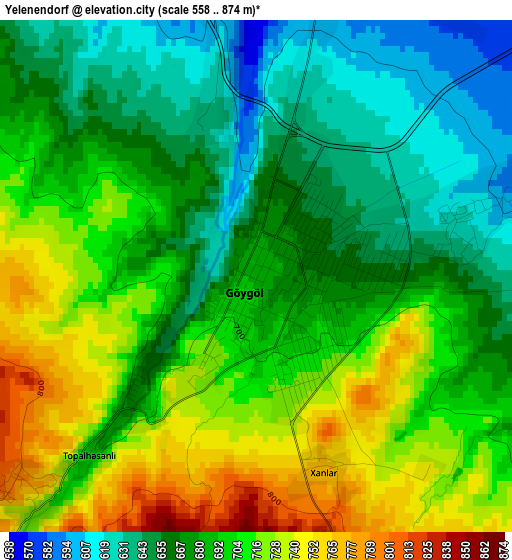
Below is the Elevation map of Yelenendorf, which displays elevation range with different colors. Scale of the first map is from 558 to 874 m (1831 to 2867 ft) with average elevation of 688.9 meters (=2260 ft) [note 1]
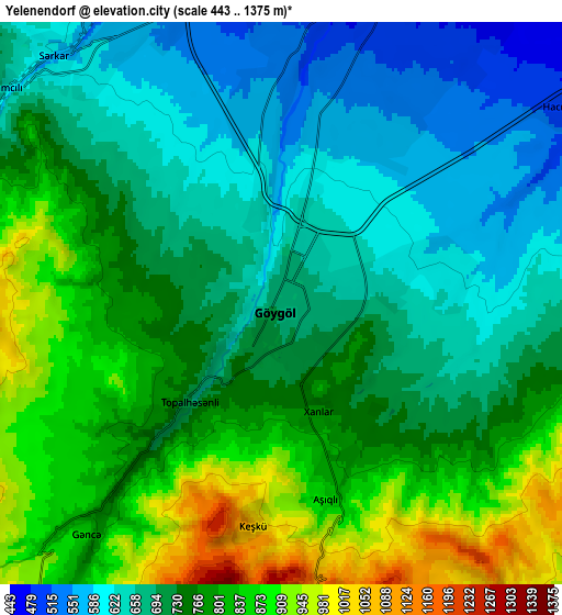
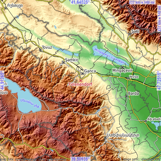
These maps also provides idea of topography and contour of this city, they are displayed at different zoom levels. More info about maps, scale and edge coordinates you can find below images.
| \ | Map #1 | Map #2 | Topo.Map |
| Scale [m] | 558..874 m | 443..1375 m | × |
| Scale [ft] | 1831..2867 ft | 1453..4511 ft | × |
| Average | 688.9 m = 2260 ft | 741.2 m = 2432 ft | × |
| Width | 7.42 km = 4.6 mi | 14.84 km = 9.2 mi | 237.5 km = 147.6 mi |
| Height | 7.42 km = 4.6 mi | 14.84 km = 9.2 mi | 237.5 km = 147.6 mi |
| ↑Max Latitude | 40.619205° | 40.652554° | 41.64525° |
| Latitude at center | 40.58584° | 40.58584° | 40.58584° |
| ↓Min Latitude | 40.552458° | 40.51906° | 39.50938° |
| ← Min Longitude | 46.274955° | 46.231009° | 44.91265° |
| Longitude center | 46.3189° | 46.3189° | 46.3189° |
| →Max Longitude | 46.362845° | 46.406791° | 47.72515° |
Nearby cities:
Cities around Yelenendorf sort by population:
• Ganja elevation 417 m
11.3 km,  18°
18°
• Shamkhor 462 m
37.1 km,  316°
316°
• Yukhary-Dashkesan 1601 m
21.2 km,  251°
251°
• Kyadabek 1460 m
42.8 km,  267°
267°
• Goranboy 156 m
39.8 km,  86°
86°
• Naftalan 251 m
43.2 km,  101°
101°
• Samux 251 m
21.3 km, 20°
• Qarayeri 255 m
22.3 km,  358°
358°
• Dolyar 341 m
39 km, 322°
• Qırmızı Samux 99 m
39.7 km,  7°
7°
• Qasım İsmayılov 228 m
25.7 km,  348°
348°
• Verkhniy Dashkesan 1592 m
23.3 km,  243°
243°
Multilingual:
 En español:
Yelenendorf elevación 686 m.
 En France:
Yelenendorf élévation 686 m.
 Auf Deutsch:
Xanlar, Helenendorf höhe über dem Meeresspiegel ist 686 m.

Sources and notes:
- [note 1] Map square and city borders are not equal. Map elevation data is calculated only from area inside that square.
- [src 1] Elevation data from geonames database provided with same terms of usage.
- [src 2] The elevation map of Yelenendorf is generated using elevation data from NASA's 3 arcsec (90m) resolution SRTM data.
- [src 3] Base (background) map © OpenStreetMap contributors tiles are generated by Geofabrik and OpenTopoMap.
Copyright & License:
This Yelenendorf Elevation Map is licensed under CC BY-SA. You may reuse any part from this page, if you give a proper credit by linking to this URL:
 More info on terms of use page.