Ordubad elevation
Ordubad (Nakhichevan, Ordubad Rayon), Azerbaijan elevation is 892 meters and Ordubad elevation in feet is 2927 ft above sea level [src 1]. Ordubad is a seat of a second-order administrative division (feature code) with elevation that is 532 meters (1745 ft) bigger than average city elevation in Azerbaijan.
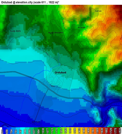
Below is the Elevation map of Ordubad, which displays elevation range with different colors. Scale of the first map is from 611 to 1822 m (2005 to 5978 ft) with average elevation of 940.3 meters (=3085 ft) [note 1]
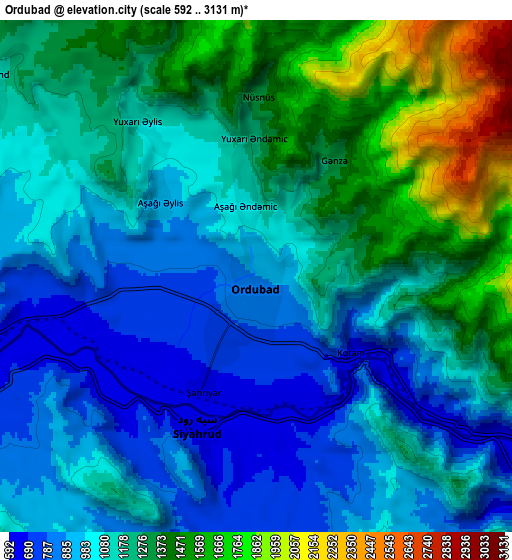
These maps also provides idea of topography and contour of this city, they are displayed at different zoom levels. More info about maps, scale and edge coordinates you can find below images.
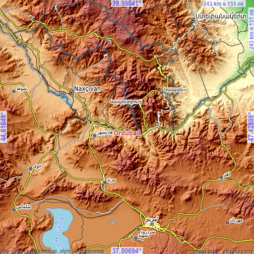
| \ | Map #1 | Map #2 | Topo.Map |
| Scale [m] | 611..1822 m | 592..3131 m | × |
| Scale [ft] | 2005..5978 ft | 1942..10272 ft | × |
| Average | 940.3 m = 3085 ft | 1154.9 m = 3789 ft | × |
| Width | 7.6 km = 4.7 mi | 15.21 km = 9.5 mi | 243.3 km = 151.2 mi |
| Height | 7.6 km = 4.7 mi | 15.21 km = 9.5 mi | 243.3 km = 151.2 mi |
| ↑Max Latitude | 38.943797° | 38.977968° | 39.99541° |
| Latitude at center | 38.90961° | 38.90961° | 38.90961° |
| ↓Min Latitude | 38.875406° | 38.841186° | 37.80694° |
| ← Min Longitude | 45.978795° | 45.934849° | 44.61649° |
| Longitude center | 46.02274° | 46.02274° | 46.02274° |
| →Max Longitude | 46.066685° | 46.110631° | 47.42899° |
Nearby cities:
Cities around Ordubad sort by population:
• Nakhchivan elevation 887 m
62.3 km,  302°
302°
• Culfa 714 m
34.4 km,  278°
278°
• Yaycı 706 m
25.3 km, 277°
• Cahri 1074 m
71.6 km,  312°
312°
• Zangilan 420 m
58.4 km,  70°
70°
• Qubadlı 482 m
68.3 km,  44°
44°
• Mincivan 335 m
62 km,  77°
77°
• Deste 696 m
10.2 km,  253°
253°
• Şahbuz 1196 m
67.5 km,  325°
325°
• Çalxanqala 1372 m
87 km, 312°
• Sumbatan-diza 791 m
17.6 km, 284°
• Tazakend 826 m
57 km, 298°
Multilingual:
 En español:
Ordubad elevación 892 m.
 En France:
Ordoubad élévation 892 m.


Sources and notes:
- [note 1] Map square and city borders are not equal. Map elevation data is calculated only from area inside that square.
- [src 1] Elevation data from geonames database provided with same terms of usage.
- [src 2] The elevation map of Ordubad is generated using elevation data from NASA's 3 arcsec (90m) resolution SRTM data.
- [src 3] Base (background) map © OpenStreetMap contributors tiles are generated by Geofabrik and OpenTopoMap.
Copyright & License:
This Ordubad Elevation Map is licensed under CC BY-SA. You may reuse any part from this page, if you give a proper credit by linking to this URL:
 More info on terms of use page.